
Bet Bet Land Use
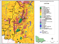 Bet Bet Landuse | This map provides an overview of land use across the Bet Bet Creek Catchment (and adjacent areas) and has been generalised from more detailed mapping completed as part of the North Central Region Land Use Mapping project. The procedure used to develop the North Central Land Use Map balanced the need for reliable data, practicality and cost effectiveness. The work was carried out by Department of Primary Industries staff at Tatura and supported by the Bureau of Rural Sciences (BRS) (external link). |
Land Use History
Information provided here is preliminary - having been gained from existing sources identified. It will be further developed as additional information becomes available.
Lexton Area (this information has been adapted from the Lexton Landcare Group Landcare Note 93/002)
The Surveyor General, Major T. Mitchell first saw the area in 1836 and described it as "a valley of the finest description". By 1840 Burnbank (as Lexton was then known) had become a centre for settlement and administration - being at the crossroads of Major Mitchell's track from Geelong to the Wimmera. The area was rapidly divided into pastoral runs in the 1840's for sheep stocking.
The discovery of gold at Clunes and then Waterloo increased populations in the region and the demand for food. By 1859, approximately 10% of the land was cleared for agriculture, mostly cropping. Steady clearing continued in the area, with most being completed by the turn of the century.
Closer settlement and settlement of soldiers following both World Wars, broke down the large holdings into smaller, intensively farmed units. The introduction of superphosphate and subterranean clover revolutionised farming in the 1930's - and significantly changing the landscape with associated drainage of wetlands and poorer drained areas. There has been a gradual increase in farm sizes across the area since the 1950's due to economic pressures - with average farm sizes in the area now at about 400 hectares.
Timor West Area
The Timor West area came to prominence after 1850 as the site of some large 'deep lead' gold mines. Deep Lead mining began at Timor in the 1860s and ceased in the 1920's. The Grand Duke Company at Timor, for example, employed some one hundred and fifty men and mined to a depth of about 120 meters (Mines Department 1937, Deep Leads of Victoria). A reef gold mine at Rathscar closed in 1928 and employed 25 people in its heyday (producing 915 ounces of gold) (Howitt 1937).
© State of Victoria (Agriculture Victoria) 1996 - 2025.

This work, Victorian Resources Online, is licensed under a Creative Commons Attribution 4.0 licence. You are free to re-use the work under that licence, on the condition that you credit the State of Victoria (Agriculture Victoria) as author, indicate if changes were made and comply with the other licence terms.
The licence does not apply to ‘branding’ or some ‘images or photographs’ that may be owned by third parties. We ask you to seek prior approval to use images using the VRO feedback form. Access to higher quality images can also be provided on request.
This page was last updated on 23/03/2020.