
Site GL157
Location: Gritjurk.
Land Mapping Unit: Dundas Tillite
Australian Soil Classification: Vertic, Mottled-Mesonatric, Grey SODOSOL (confidence level 1).
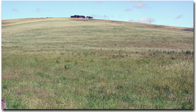 Site GL157 Landscape. | 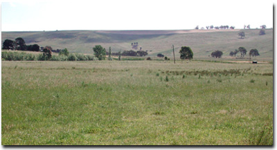 View towards Bryan Creek from Site GL157. |
General Land Unit Description:
This land unit consists of the Permian glacial, fluvial and lacustrine sediment outcrop, in the valleys of the Dundas Tablelands. The landform is mainly dissected low hills and rises. The main soil types occurring in this unit are Black Sodosols or Black Vertosols. Grey Sodosols commonly occur on the lower slopes. This land unit is highly susceptible to water erosion, due mainly to the deep sodic soils. As the Tillite is a mixture of materials (not totally consolidated) the soils (particularly the grey soils) tend to be less stable when exposed. Land slips are common in this land unit.
Site Description:
This site occurs on the Dundas Tablelands. It is situated on a colluvial fan below a rise, leading to a broad alluvial plain. Black clay veins moving through the profile are an indication of the cracking nature of the soil. The internal drainage of the soil is imperfectly to poorly drained. The subsoil becomes considerably more sodic at depth, which may be a cause of the impeded internal drainage. There would be significant run-off accumulating on the site from the dissected tablelands above. The topsoil at this site may be the result of more recent accumulation. On some of the steeper slopes of the Merino Tablelands, relic soil slumping is evident, and the slopes are still susceptible to landslips.
Slope: 4%
Geology: Permian tillite.
Landform Pattern: Undulating rises.
Position in Landscape: Lower slope.
Internal Drainage: Imperfectly to poorly drained.
Soil Profile Morphology:
Surface Soil
| A1 | 0-20 cm | Dark brown (7.5YR3/2); heavy clay loam; fine red (2.5YR4/6) oxidised root channel mottling common; strong very fine sub-angular blocky structure; weak consistence (moist); pH 5.8; clear change to: | 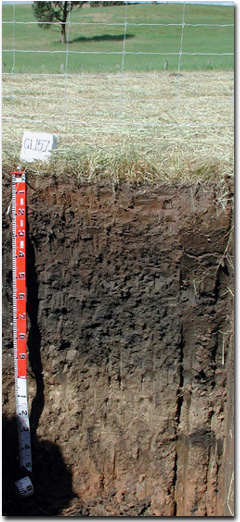 Site GL157 Profile. |
| Subsoil | |||
| B21 | 20-35 cm | Very dark grey (7.5YR3/1); medium heavy clay; many faint fine brown mottles (7.5YR4/4); moderate fine blocky structure; very firm consistence (dry); very plastic when wet; pH 6.2; gradual change to: | |
| B22 | 35-55 cm | Very dark greyish brown (10YR3/2); medium heavy clay to heavy clay; many fine distinct brown mottles (7.5YR4/4); moderate fine blocky structure; very firm consistence (dry); very plastic when wet; black veins evident due to cracking; pH 6.8; gradual change to: | |
| B23 | 55-75 cm | Very dark grey (2.5Y3/1); medium heavy clay; fine distinct light olive brown mottles common (2.5Y5/4); moderate to strong structure; very plastic when wet; black veins evident due to cracking; pH 7.8; gradual change to: | |
| B24 | 75-90 cm | Dark grey (2.5Y4/1); heavy clay; a few faint fine yellow mottles; moderate to strong structure; black veins evident due to cracking; pH 8.5; gradual change to: | |
| B25 | 90-145 cm | Light olive brown (2.5Y5/3); heavy clay to medium heavy clay; moderate coarse prismatic structure; consistence strong when dry to very firm when wet; very few fine calcareous flecks; black veins evident due to cracking; gradual transition to: | |
| C | 145-155 cm | Brown (7.5YR4/4); heavy clay; black veins evident due to cracking. | |
Key Profile Features:
- Cracking clay subsoil.
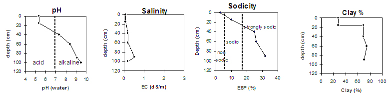
Soil Profile Characteristics:
pH | Salinity Rating | |||
Surface (A1 horizon) | Moderately Acid | Low | Non-Sodic | None1 |
Subsoil (40-55 cm) | Slightly Acid | Low | Sodic | Strong to Complete |
Deeper Subsoil (55-80 cm) | Moderately Alkaline | Medium | Strongly Sodic | Strong to Complete |
 |
Horizon | Horizon Depth (cm) | pH (water) | pH (CaCl2) | EC 1:5 | Exchangeable Aluminium mg/kg | Exchangeable Acidity meq/100g | Exchangeable Cations | |||
Ca | Mg | K | Na | |||||||
meq/100g | ||||||||||
A1 | 0-20 | 5.8 | 4.6 | 0.10 | 62 | 17 | 3.7 | 5.4 | 0.36 | 1.5 |
B21 | 20-35 | 6.2 | 5.0 | 0.12 | 15 | 15 | 6.2 | 11 | 0.69 | 2.8 |
B22 | 35-55 | 6.8 | 5.6 | 0.17 | 11 | 7.1 | 13 | 0.81 | 3.7 | |
B23 | 55-75 | 7.8 | 6.9 | 0.38 | 7.3 | 15 | 1.1 | 5.7 | ||
B24 | 75-90 | 8.5 | 7.8 | 0.83 | 7.9 | 18 | 1.0 | 8.0 | ||
B25 | 90-145 | 8.6 | 5.5 | 0.79 | 6.3 | 14 | 0.6 | 7.1 | ||
Horizon | Horizon Depth (cm) | Field Capacity pF2.5 | Wilting Point pF4.2 | Coarse Sand (0.2- 2.0 mm) | Fine Sand (0.02- 0.2 mm) | Silt (0.002- 0.02 mm) | Clay (<0.002 mm) |
A1 | 0-20 | 39 | 19 | 10 | 16 | 27 | 41 |
B21 | 20-35 | 43 | 24 | 5 | 5 | 5 | 61 |
B22 | 35-55 | 47 | 24 | 10 | 9 | 9 | 62 |
B23 | 55-75 | 47 | 25 | 20 | 19 | 20 | 64 |
B24 | 75-90 | 48 | 24 | 61 | 62 | 64 | |
B25 | 90-145 |
Profile Described By: Natalie Baxter, Nathan Robinson, Grant Boyle and Mark Imhof (October 2001).
© State of Victoria (Agriculture Victoria) 1996 - .

This work, Victorian Resources Online, is licensed under a Creative Commons Attribution 4.0 licence. You are free to re-use the work under that licence, on the condition that you credit the State of Victoria (Agriculture Victoria) as author, indicate if changes were made and comply with the other licence terms.
The licence does not apply to ‘branding’ or some ‘images or photographs’ that may be owned by third parties. We ask you to seek prior approval to use images using the VRO feedback form. Access to higher quality images can also be provided on request.
This page was last updated on .