Site SW18a
Location: Glenormiston College (North Farm).
Australian Soil Classification: Vertic, Subnatric, Brown SODOSOL
Northcote Factual Key: Dy1.23
Great Soil Group: solodic
Geology: Quaternary basalt (Qvn).
General Landscape Description: Level Plain.
Site Description: Reserve at the edge of a grazing paddock.
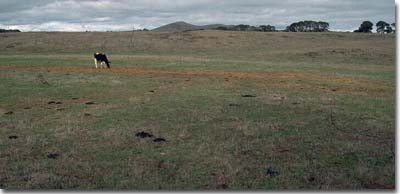 Site SW18a Landscape |
Soil Profile Morphology:
Surface Soil
| A1 | 0-20 cm | Very dark brown (10YR2/2); fine sandy clay loam; weak consistence dry; pH 5.1; gradual change to: | |
| A2 | 20-30 cm | Dark brown (10YR3/3); clay loam (fine sandy); firm consistence slightly moist; pH 5.7; gradual change to: | |
| Subsoil | |||
| B21 | 30-50 cm | Brown (10YR4/3); medium heavy clay; moderate blocky, parting to fine blocky structure; firm consistence moist; pH 6.3; clear change to: | |
| B22 | 50-70 cm | Very dark grey (10YR3/1); heavy clay; moderate coarse blocky structure; firm to very firm consistence moist; pH 7.1: | |
| B23 | 70-100 cm | Brown (10YR4/3) with a slight yellowish brown (10YR5/4) mottle; heavy clay; firm to very firm consistence moist; contains a few (2-5%) manganese flecks and basalt rocks (30 cm in size); slickensides present; pH 8.2 | |
- Strong texture contrast between surface (A) horizon (29% clay) and the sodic subsoil (B21) horizon (46% clay).
- Vertic properties i.e. significant shrink-swell characteristics in the subsoil.
pH | Salinity Rating | |||
Surface (A1 horizon) | strongly acid | low | non-sodic | none |
Subsoil (B21 horizon) | slightly acid | very low | sodic | strong 1 |
Deeper subsoil (at 80 cm) | moderately alkaline | low-mod | strongly sodic | strong 1 |
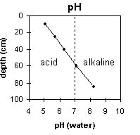 | 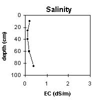 | 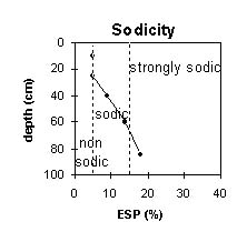 | 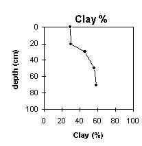 |
The surface soil is strongly acid. The subsoil is slightly acid becoming moderately alkaline at 80 cm. | The salinity rating is low becoming low to moderate at 80 cm. | The surface is non-sodic. The subsoil is sodic becoming strongly sodic at 70 cm. | The clay content gradually increases with depth. |
Horizon | Horizon Depth (cm) | pH (water) | pH (CaCl2) | EC 1:5 | Exchangeable Cations | |||
Ca | Mg | K | Na | |||||
meq/100g | ||||||||
A1 | 0-20 | 5.1 | 4.7 | 0.2 | 6.2 | 5.6 | 1.4 | 0.58 |
A2 | 20-30 | 5.7 | 5.1 | 0.12 | 5.4 | 6.1 | 1.3 | 0.66 |
B21 | 30-50 | 6.3 | 5.3 | 0.11 | 6.1 | 9.9 | 1.6 | 1.7 |
B22 | 50-70 | 7.1 | 6 | 0.18 | 8.5 | 15 | 1.6 | 4.1 |
B23 | 70-100 | 8.2 | 7.2 | 0.4 | 9.9 | 20 | 1 | 6.5 |
Horizon | Horizon Depth (cm) | NaCl % | Wilting Point pF4.2 | Coarse Sand (0.2- 2.0 mm) | Fine Sand (0.02- 0.2 mm) | Silt (0.002- 0.02 mm) | Clay (<0.002 mm) |
A1 | 0-20 | 25 | 7 | 28 | 22 | 29 | |
A2 | 20-30 | 18 | 8 | 32 | 21 | 30 | |
B21 | 30-50 | 24 | 8 | 26 | 15 | 46 | |
B22 | 50-70 | 28 | 4 | 21 | 14 | 56 | |
B23 | 70-100 | 0.06 | 29 | 4 | 20 | 13 | 48 |
Management Considerations:
Whole Profile
- Plant available water capacity (PAWC) is considered to be low-medium (estimated at 96 mm). This is based on available laboratory data and assumes an effective rooting depth of 70 cm. Rooting depth will be restricted by the dense and strongly sodic subsoil. The availability of moisture to the plant depends to a large degree on soil structure and consistence. In dense and coarsely structured subsoils such as these, it is likely that there will be a large amount of unused ‘available’ moisture in the subsoil.


