
LP61a & b
Location: Lexton
Australian Soil Classification: Vertic (and Manganic), Mottled-Subnatric, Brown SODOSOL
General Landscape Description: Located on a minimal midslope position on an undulating volcanic plain (slope 1.5%). This site is in a more poorly drained situation than site LP60.
Geology: Quaternary basalt.
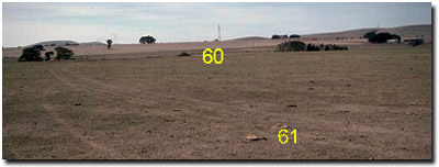 LP60 & LP61 Landscape |
Site LP61b
Soil Profile Morphology:
| Surface Soil | 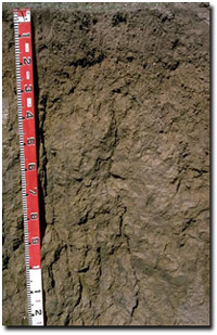 LP61b Profile | ||
| A11 | 0-10 cm | Dark greyish brown (10YR4/2); very fine sandy clay loam; hardsetting surface condition; moderate very fine to fine polyhedral structure; weak consistence moist; pH 5.2; abrupt change to: | |
| A12 | 10-15cm | Dark brown (10YR4/3); very fine sandy clay loam; weak consistence moist; contains very many (50%) manganese nodules (3 mm); pH 5.7; abrupt change to: | |
| Subsoil | |||
| B21 | 15-20 cm | Yellowish brown (10YR5/4); medium clay; moderate fine polyhedral structure; firm consistence moist; contains many (20%) manganiferous and ferro-manganiferous nodules (3-10 mm size); pH 5.9; abrupt change to: | |
| B22 | 20-40 cm | Brown (10YR5/3) with brownish yellow (10YR6/6) mottles; medium to heavy clay; moderate medium prismatic structure; strong consistence dry; pH 6.7; gradual change to: | |
| B23 | 40-70 cm | Brown (10YR4/3) with a yellowish brown (10YR5/8) mottles; heavy clay; moderate very coarse prismatic structure (with dark stains on ped faces); strong consistence moist; pH 7.3; gradual change to: | |
| B24 | 70+ cm | Brown (10YR5/3) with yellowish brown (10YR5/6) mottles; heavy clay; moderate very coarse prismatic, parting to moderate very coarse blocky structure; dark manganiferous stains; slickensides present; strong consistence moist; pH 8.0. | |
Key Profile Features:
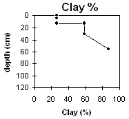
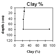
- Strong texture contrast between the surface (A) horizons (26% clay) and the subsoil (B21) horizon (>59% clay).
- Variable presence and depth of subsurface (A2) horizon due to gilgai microrelief.
- Vertic properties (i.e. slickensides) in deeper subsoil.
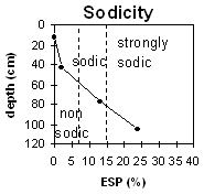
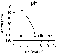
pH | Salinity Rating | |||
Surface (A1 horizon) | Strongly Aacid | Very Low | Non-Sodic | None |
Subsoil (B21 horizon) | Moderately Acid | Very Low | Sodic | None1 |
Deeper subsoil (at 80 cm) | Moderately Alkaline | Very Low | Sodic | Slight-Moderate |
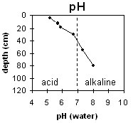 | 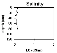 |  |  |
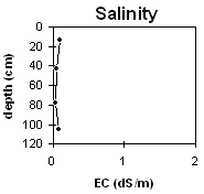
Horizon | Horizon Depth cm | pH (water) | pH CaCl2 | EC dS/m | Exchangeable Cations | Exchangeable Aluminium mg/kg | Field Capacity pF2.5 | Wilting Point pF4.2 | Coarse Sand (0.2-2.0mm) | Fine Sand (0.02-0.2mm) | Silt (0.002-0.02mm) | Clay (<0.002mm) | |||
Ca | Mg | K | Na | ||||||||||||
meq/100g | |||||||||||||||
A11 | 0-10 | 5.2 | 4.5 | 0.14 | 4.3 | 2 | 0.3 | 0.2 | 37 | 37.2 | 17.1 | 2 | 39 | 24 | 26 |
A12 | 10-15 | 5.7 | 4.7 | 0.07 | 4.2 | 3.2 | 0.2 | 0.3 | |||||||
B21 | 15-20 | 5.9 | 5 | 0.12 | 4.2 | 5.2 | 0.2 | 0.7 | 38 | 26.6 | 4 | 27 | 15 | 59 | |
B22 | 20-40 | 6.7 | 5.4 | 0.05 | 5.6 | 11 | 0.2 | 1.5 | 48.5 | 35.5 | 1 | 7 | 1 | 87 | |
B23 | 40-70 | 7.3 | 6 | 0.06 | 4.9 | 13 | 0.4 | 2.8 | |||||||
B24 | 70+ | 8 | 6.5 | 0.13 | 4.4 | 14 | 0.4 | 4 | |||||||
Management Considerations:
Whole Profile
- Plant available water capacity (PAWC) is relatively moderate (estimated at approximately 120 mm). This is based on available laboratory data and assumes an effective rooting depth of 60 cm.
- The strongly acid surface horizon indicates that aluminium and manganese toxicity may occur. The exchangeable aluminium measured in the laboratory is not high but is only taken from one point in the paddock. A pH/aluminium test (sampled at the paddock level) may be appropriate to determine if lime is needed. Raising surface soil pH will help reduce any toxic effects.
- The surface A1 horizon is similar to the surface of Site 60 (in terms of structure, particle size, nitrogen and organic matter). However, it is shallower and underlain by a less favourable subsoil.
- The organic carbon and nitrogen levels are reasonable. Maintaining organic matter levels is important for soils with quite high silt and fine sand contents as it assists aggregate stabilisation.
- The bleached subsurface (A2) horizon is irregular in occurrence but can be quite deep (ie. up to 60 cm). These bleached layers have a very low plant available water capacity (PAWC) and are poor in nutrients. This layer will become "spewy" when wet as water builds up on top of the slowly permeable subsoil (B) horizons. The irregular occurrence of the bleached horizons is likely to result in variations in crop response across the paddock.
- The upper subsoil is coarsely structured and becomes more sodic with increasing depth. Also, from 20 cm, the calcium:magnesium ratio (<0.5) is low. These conditions are likely to result in restricted root and water movement through the profile.
- The lower subsoil exhibits vertic properties and is likely to shrink and swell considerably on wetting and drying. This may have some implications for engineering purposes (e.g. building foundations).
- Was originally "crabholey" country, but has since been levelled out by cultivation.
Site LP61a
Soil Profile Morphology:
 LP61a Profile | In areas, a deep irregular bleached subsurface (A2) horizon can occur. It varies in depth from approximately 20 cm to 60 cm and is probably associated with the original gilgai microrelief. The bleached horizon has a silty clay loam texture and contains a large amount of ferro-manganiferous nodules (mostly greater than 1 cm diameter) towards its base. The bleached horizon is underlain by a yellowish brown (10YR5/4) mottled medium heavy clay. |
pH | Salinity Rating | |||
Surface (A1 horizon) | Strongly Acid | Very Low | Non-Sodic | None |
Subsoil (B21 horizon) | Slightly Acid | Very Low | Sodic | None1 |
Deeper subsoil (at 1 m) | Slightly Alkaline | very low | Strongly Sodic | _ |
 |  | |  |
Horizon | Horizon Depth cm | pH (water) | pH CaCl2 | EC dS/m | Exchangeable Cations | Exchangeable Aluminium mg/kg | Field Capacity pF2.5 | Wilting Point pF4.2 | Coarse Sand (0.2-2.0mm) | Fine Sand (0.02-0.2mm) | Silt (0.002-0.02mm) | Clay (<0.002mm) | |||
Ca | Mg | K | Na | ||||||||||||
meq/100g | |||||||||||||||
A1 | 0-25 | 5.2 | 4.5 | 0.09 | 4.2 | 1.7 | 0.2 | 0.1 | 29 | 35 | 15.3 | 1 | 39 | 30 | 25 |
A2 | 25-60 | 6.1 | 4.9 | 0.05 | 2.3 | 2 | 0.2 | 0.2 | 23.8 | 9.6 | 2 | 47 | 29 | 22 | |
B21 | 60-95 | 6.9 | 5.5 | <0.05 | 3.4 | 11 | 0.2 | 2.2 | 44.3 | 35.8 | 0.9 | 7 | 0 | 92 | |
B22 | 95+ | 7.1 | 6 | 0.08 | 2.9 | 6.7 | 0.3 | 3.1 | |||||||
Profile Described By: Mark Imhof, Paul Rampant, Karen de Plater (April 1995).
© State of Victoria (Agriculture Victoria) 1996 - 2025.

This work, Victorian Resources Online, is licensed under a Creative Commons Attribution 4.0 licence. You are free to re-use the work under that licence, on the condition that you credit the State of Victoria (Agriculture Victoria) as author, indicate if changes were made and comply with the other licence terms.
The licence does not apply to ‘branding’ or some ‘images or photographs’ that may be owned by third parties. We ask you to seek prior approval to use images using the VRO feedback form. Access to higher quality images can also be provided on request.
This page was last updated on 23/03/2020.