
Land Degradation
See also Statewide Land Degradation
Tunnel Erosion in East Gippsland | East Gippsland Soil Erosion Management Plan
The tunnel and gully erosion maps for the East Gippsland Catchment Management Region are subsets from the original data presented in the articles on tunnel erosion and gully erosion on the Statewide VRO website, so that the accuracy of information has not been improved. Tunnelling was generally observed in small clusters throughout much of the region, particularly surrounding parts of the Mitchell and Nicholson Rivers near Bairnsdale and along the Snowy River near Orbost. However, some examples may have been destroyed (such as those discussed by Aldrick et al. 1992) whilst new tunnels may have formed elsewhere and are not marked.
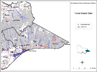 Tunnel Erosion Sites | Similarly, the spatial distribution of gully erosion in the region may have altered since the time that the map was constructed, as may have some of the sites found more recently by Aldrick et al. (1988, 1992). The highest density of gullying was 0.2 - 0.5 km/km2 along the Tambo River south of Omeo and an area with a density of < 0.2 km/km2 was mapped south-west of Bairnsdale. Most of the tunnel erosion sites were located in areas where the gully density was 'low'. Almost all of the region is public land for which there are no data on land degradation. | 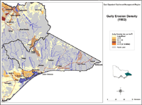 Gully Erosion Sites |
References
Aldrick, J.M., Hook, R.A., van de Graaff, R.H.M., Nicholson, B.M., O’Beirne, D.A. and Schoknecht, N.R. (1988). 'A study of the land in the catchment of the Gippsland Lakes. Volume 1'. Department of Conservation, Forests and Lands Technical Communication No. 17. (Department of Conservation, Forests and Lands, Land Protection Division, East Melbourne)
Aldrick, J.M., Hook, R.A., van de Graaff, R.H.M., Nicholson, B.M., O’Beirne, D.A. and Schoknecht, N.R. (1992). ). 'A study of the land in the catchment of the Gippsland Lakes. Volume 2'. Department of Conservation, Forests and Lands Technical Communication No. 17. (Department of Conservation and Natural Resources, Land and Catchment Protection Branch, East Melbourne)
© State of Victoria (Agriculture Victoria) 1996 - 2025.

This work, Victorian Resources Online, is licensed under a Creative Commons Attribution 4.0 licence. You are free to re-use the work under that licence, on the condition that you credit the State of Victoria (Agriculture Victoria) as author, indicate if changes were made and comply with the other licence terms.
The licence does not apply to ‘branding’ or some ‘images or photographs’ that may be owned by third parties. We ask you to seek prior approval to use images using the VRO feedback form. Access to higher quality images can also be provided on request.
This page was last updated on 23/03/2020.