
Invasive Plants
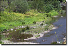 Large tracts of the upper Tambo River's riparian zone is infested with Blue Periwinkle weeds. | For maps showing the current and potential distribution of some major invasive plants in Victoria - refer to Invasive Plants on the Statewide VRO website. Weeds have a serious impact on agricultural enterprises and various species are causing serious degradation of native vegetation and threatening the region's biodiversity values. Despite large commitments of time and money by private landholders and public land managers, weeds remain a major land management problem throughout the region. The Department of Sustainability and Environment (DSE) monitors infestations of priority weeds and records details, including the area and severity of infestation, in its Integrated Pest Management System (IPMS) database. Mapping and monitoring is undertaken on a continuous basis but is not complete for the region. |
Related Links
Invasive Plants and Animals information on the DSE website (external link).
© State of Victoria (Agriculture Victoria) 1996 - 2025.

This work, Victorian Resources Online, is licensed under a Creative Commons Attribution 4.0 licence. You are free to re-use the work under that licence, on the condition that you credit the State of Victoria (Agriculture Victoria) as author, indicate if changes were made and comply with the other licence terms.
The licence does not apply to ‘branding’ or some ‘images or photographs’ that may be owned by third parties. We ask you to seek prior approval to use images using the VRO feedback form. Access to higher quality images can also be provided on request.
This page was last updated on 23/03/2020.