
Declared Special Areas
In the East Gippsland region, there are ten Special Areas classified as Declared Water Supply Catchments. These areas were formerly called Proclaimed Water Supply Catchments under the now repealed Soil Conservation and Land Utilisation Act 1958. Declared Water Supply Catchment Areas are identified because of their significance as a source of water.
Under the Act, Special Area Plans, which can be prepared for declared areas, specify how particular land management issues in these areas will be addressed. Land Use Determinations (LUDs) previously prepared for these water supply catchments are now regarded as Special Area Plans (SAPs) under the Catchment and Land Protection Act 1994. Special Area Plans have been prepared for the Rocky River and Nicholson River catchments.
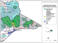 Declared Special Areas | The Declared Water Supply Catchments map shows those catchment areas as proclaimed under the Soil Conservation and Land Utilisation Act, 1958 in conjunction with the Land Conservation Act, 1970. This layer identifies domestic Water Supply Catchments that are subject to a Land Use Determination or a Land Use Notice. Data was derived from the Proclaimed Water Supply Catchment (L100) layer in the Department of Sustainability and Environment Corporate Geospatial Data Library. Mapping was undertaken by the Centre for Land Protection Research. |
Declared Water Supply Catchment Areas in the East Gippsland Region:
Name of Catchment | Area (km2) | Year of Gazettal | For the Protection of: | Special Area Plan / LUD |
| Buchan River (Buchan) | 801 | 1984 | Town | |
| Mitchell River (East Gippsland) | 3 900 | 1981 | Irrigation, Town | |
| Nicholson River | 451 | 1975 | Town | Yes |
| Tambo River | 2 650 | 1984 | Town, Industrial | |
| Betka River | 117 | 1973 | Town | |
| Cann River | 642 | 1976 | Town | |
| Brodribb River (Orbost) | 935 | 1986 | Town water, Stock and Domestic use | |
| Rocky River | 24 | 1967 | Town | Yes |
| Bemm River | 904 | 1986 | Town water, Stock and Domestic use | |
| Boggy Creek (Nowa Nowa) | 271 | 1984 | Town water and Industrial use |
Source: Catchment and Land Protection Act 1994, DWR (1989), NRE (1998 pres); 1 chain = 20.12 m; (a) any clearing operations greater than 14o shall be carried out in accordance with conditions made or approved by the Soil Conservation Authority (b) Morwell W.W.T. off-take weir (c) from banks of streams and watercourses specified on Plan No. 1870; (d) on specified sections of the Macalister, Wellington, Barkley Rivers and Glenmaggie Creek; (e) applying to pasture establishment, pine plantation establishment or any other purpose, but excluding forest operations carried out under management prescriptions approved by the Soil Conservation Authority; (f) off-take weir at Mirboo; (g) streams and watercourses shown on Plan No. S-101 but also includes other streams, watercourses and springs in the catchment; (h) Nicholson Reservoir and water supply off-take as shown on Plan No. S-1411; (i) Nicholson and Barmouth Rivers as shown on Plan No. S-1411; (j) any domestic water supply off-take managed by South Gippsland Water
For more information regarding Declared Water Supply Catchments or Land Use determinations in the East Gippsland Region contact:
Department of Primary Industries Information Centre
136 186
References
Commonwealth of Australia (C of A) and State of Victoria (1999). Gippsland Regional Forest Agreement: Comprehensive Regional Assessment. AGPS, Canberra.
Department of Water Resources (1989). A Water Resource Handbook, Melbourne.
© State of Victoria (Agriculture Victoria) 1996 - 2025.

This work, Victorian Resources Online, is licensed under a Creative Commons Attribution 4.0 licence. You are free to re-use the work under that licence, on the condition that you credit the State of Victoria (Agriculture Victoria) as author, indicate if changes were made and comply with the other licence terms.
The licence does not apply to ‘branding’ or some ‘images or photographs’ that may be owned by third parties. We ask you to seek prior approval to use images using the VRO feedback form. Access to higher quality images can also be provided on request.
This page was last updated on 23/03/2020.