
Soil/Landform Unit 32
Landform Unit Description
Page top
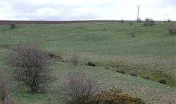
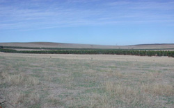 Lower slopes and depression (most likely a former swamp) now supporting blue gums in belts |
0.11% of CMA region This unit falls predominantly within the Dissected Uplands associated with volcanic landforms of the Western Uplands, between Garibaldi and Grenville. There is a minor occurrence on the Western Plains adjoining the Western Uplands, east of Maude. The northern occurrence is surrounded by sedimentary terrain (Unit 2) and connected to a basalt flow (Unit 47). The soils are predominantly neutral and acidic mottled brown texture contrast soils (Chromosols and Sodosols) with more friable red gradational (earth) soils (Ferrosols) on the upper and mid slopes (associated with the eruption point) and black self mulching soils (Vertosols) in the depressions and occasionally on lower slopes. Rainfall is higher to the north, the southern occurrence is drier. The low-lying areas are prone to waterlogging with slow site drainage and some compaction. The sloping areas are more susceptible to sheet and rill erosion though moderately rapid site drainage and some soil friability. Depth and stoniness may vary enough to affect permeability and land use; mainly grazing. |  |
 Soils of the mid and upper slopes offer potential for cropping or other intensive agricultural enterprises | 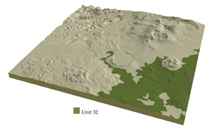 |
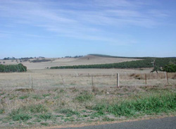
|  Steep gullies near Hardies Hill |
Component | 1 | 2 | 3 | 4 | 5 | 6 |
Proportion of soil-landform unit | 18% | 18% | 23% | 2% | 28% | 11% |
| CLIMATE Rainfall (mm) | Annual: 730 | |||||
| Temperature (oC) | Minimum 7, Maximum 18 | |||||
| Precipitation less than potential evapotranspiration | October-March | |||||
| GEOLOGY Age and lithology | Pleistocene basalt | Recent sands, silts and clays | Pleistocene basalt | |||
| Geomorphology | ||||||
| LANDUSE | Uncleared: Nature conservation Cleared: Grazing; occasional cropping (cereal); softwood and hardwood plantations | |||||
| TOPOGRAPHY Landscape | Low hills | |||||
| Elevation range (m) | 79-443 | |||||
| Local relief (m) | 45 | |||||
| Drainage pattern | Dendritic | |||||
| Drainage density (km/km2) | 1.9 | |||||
| Landform | Scarps with local rock outcrop | Creek bed | Volcanic cone | Swamps and depressions | Gently undulating plains | Depressions and terraces |
| Landform element | Slope | Floodplain | Slopes and crest | Long gentle upper slopes | ||
| Slope and range (%) | 13 (8/25) | 2 (0-3) | 17 (5-40) | 1 (0-1) | 1 (1-3) | 1 (1-2) |
| Slope shape | Convex | Straight | Straight | Flat | Straight | Straight |
| NATIVE VEGETATION Structure | Open forest | Open forest | Open forest | Woodland | Woodland | |
| Dominant species | E. viminalis, E. ovata | E. viminalis, E. ovata | E. viminalis, E. radiata | E. ovata | E. ovata, E. viminalis, E. rubida, E. obliqua | E. viminalis, E. radiata |
| SOIL Parent material | In situ weathered rock | Unconsolidated sedimentary and in situ weathered rock | In situ weathered rock | Unconsolidated sands, silts and clays | In situ weathered rock | Unconsolidated gravel, sand, silt and clay |
| Description (Corangamite Soil Group) | Black clay soil, coarse structure (31) | Stony red gradational soil (40) | Mottled brown, yellow or grey sodic texture contrast soil, coarse structure (35) | Dark brown soil - variable (34) | ||
| Soil type sites | ||||||
| Surface texture | Clay loam | Clay | Clay loam | Light clay/clay | Clay loam | Fine sandy clay loam |
| Permeability | High | Low | High | Low | Moderate to low | Moderate to low |
| Depth (m) | 1 | 1.5 | 1 | 2 | 1.5 | 2 |
| LAND CHARACTERISTICS, POTENTIAL AND LIMITATIONS | Scarp slopes combined with hardsetting surfaces results in overland flow. Soils are vulnerable to sheet and rill erosion. | Poorly drained soils with a low permeability. Overland flow and waterlogging may cause compaction and streambank erosion where exposed. | Steep slopes result in overland flow. Leaching of nutrients and rill and sheet erosion occur where soils lack ground cover. | Slowly permeable soils experience waterlogging and compaction. | Hardsetting surfaces with slowly permeable subsoils cause overland flow and waterlogguing may cause compaction as well as sheet erosion. | Low-lying areas receiving drainage experience severe waterlogging. Gully erosion may occur where subsoils are sodic. |
© State of Victoria (Agriculture Victoria) 1996 - 2025.

This work, Victorian Resources Online, is licensed under a Creative Commons Attribution 4.0 licence. You are free to re-use the work under that licence, on the condition that you credit the State of Victoria (Agriculture Victoria) as author, indicate if changes were made and comply with the other licence terms.
The licence does not apply to ‘branding’ or some ‘images or photographs’ that may be owned by third parties. We ask you to seek prior approval to use images using the VRO feedback form. Access to higher quality images can also be provided on request.
This page was last updated on 23/03/2020.