
SW86
|
| SW86 | 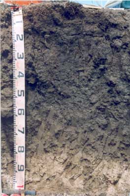 Vertic (& Calcic), Mottled-Mesonatric, Black SODOSOL The large amounts of calcium carbonate present in the deeper soil are a common feature in soils in the eastern portion of the Victorian Volcanic Plain. | |
| 4 km West of Winchelsea, Ondit Road | |||
| Gently undulating plain | |||
| Quaternary volcanics: basalt | |||
| Depression, flat | |||
| 0 | |||
| 0 | |||
Horizon | Depth (cm) | Description | ||
Ap | 0-8 | Very dark brown (10YR2/2 moist), greyish brown (10YR5/2 dry); sandy clay loam; rusty root channel mottling prominent; hard-setting; strong consistence; pH 6.2; clear boundary to: | ||
A2 | 8-17 | Very dark greyish brown (10YR3/2 moist and 10YR5/1 dry); loam; rusty mottling prominent (~5% fine magnetic buckshot); strong consistence; pH 6.9; abrupt boundary to: | ||
B21tg | 17-40 | Very dark greyish brown (10YR3/2 moist), dark greyish brown (10YR4/2 dry) with olive grey (5Y5/2 moist) mottles in ped interiors, and prominent yellowish brown (10YR5/8 moist) mottles associated with root channels; light medium clay to medium clay; many (~25%); roughly coarse prismatic (~100 mm), parting to coarse (mostly rough-face) blocky and angular coarse blocky; very strong consistence, pH 8.1; clear boundary to: | ||
B22ss | 40-60 | Very dark greyish brown (2.5Y3/2 moist); fine lenticular and polyhedral structure; moderately slickensided; pH 8.6; clear boundary to: | ||
B23 | 60-80 | Dark greyish brown (2.5Y4/2 moist); light medium clay; apedal; pH 8.8; clear boundary to: | ||
B24kg | 80-200 | Olive to light olive grey (5Y6/2-5/3 moist); fine brownish yellow (10YR6/8 moist) mottles; soft, yellowish white carbonate; calcareous continues to 2 metres; pH 9.2. | ||
| Management considerations | ||||
| The dense, coarsely-structured sodic subsoil is dispersive, restricting root growth and drainage. The subsoil displays vertic features (i.e. slickensides) which indicates that significant shrinking and swelling occurs during wetting and drying cycles. This may have engineering implications and is likely to explain the variability in surface horizon depth across the trench. The subsoil has a high level of soluble salts, which will restrict the growth of salt-sensitive species. | ||||
Analytical data
Site SW86 | Sample depth | pH | EC | NaCl | Ex Ca | Ex Mg | Ex K | Ex Na | Ex Al | Ex acidity | FC (-10kPa) | PWP (-150kPa) | KS | FS | Z | C | |
Horizon | cm | H2O | CaCl2 | dS/m | % | cmolc/kg | cmolc/kg | cmolc/kg | cmolc/kg | mg/kg | cmolc/kg | % | % | % | % | % | % |
Ap | 0-8 | 6.2 | 5.7 | 0.24 | N/R | 7.3 | 8.9 | 0.72 | 1.4 | <10 | 12 | 35 | 17.9 | 20.2 | 30.5 | 14 | 28 |
A2 | 8-17 | 6.9 | 6.2 | 0.15 | N/R | 4 | 5.2 | 0.2 | 1 | N/R | N/R | 22.2 | 8.9 | 26.1 | 39.6 | 15 | 18 |
B21tg | 17-40 | 8.1 | 7.3 | 0.6 | 0.11 | 4.4 | 12 | 0.7 | 3.8 | N/R | N/R | 38.7 | 18.2 | 15.1 | 31.8 | 12.5 | 37 |
B22ss | 40-60 | 8.6 | 8.1 | 1.6 | 0.4 | 5.1 | 18 | 0.8 | 7.5 | N/R | N/R | 46.6 | 24.9 | 11.6 | 24.4 | 13 | 47.5 |
B23 | 60-80 | 8.8 | 8.5 | 2 | 0.46 | 5 | 19 | 0.7 | 8.1 | N/R | N/R | N/R | N/R | N/R | N/R | N/R | N/R |
B24kg | 80-200 | 9.2 | 8.6 | 1.3 | 0.25 | N/R | N/R | N/R | N/R | N/R | N/R | N/R | N/R | N/R | N/R | N/R | N/R |
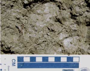
 Rocky soil on low rises to the west of SW86 |  Contrasting shallow black self mulching soils on the rise and grey soils on the lower plain |
© State of Victoria (Agriculture Victoria) 1996 - 2025.

This work, Victorian Resources Online, is licensed under a Creative Commons Attribution 4.0 licence. You are free to re-use the work under that licence, on the condition that you credit the State of Victoria (Agriculture Victoria) as author, indicate if changes were made and comply with the other licence terms.
The licence does not apply to ‘branding’ or some ‘images or photographs’ that may be owned by third parties. We ask you to seek prior approval to use images using the VRO feedback form. Access to higher quality images can also be provided on request.
This page was last updated on 23/03/2020.