
SW96
|
| SW96 | 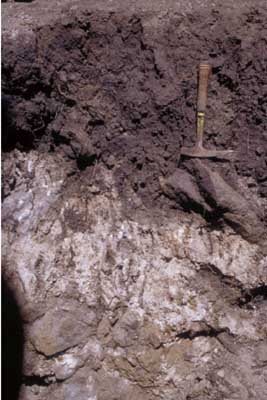 Vertic (& Sodic), Hypercalcic, Black DERMOSOL | |
| Steiglitz road, north west of junction with Geelong-Ballan road | |||
| Undulating rises | |||
| Quaternary Volcanics: basalt | |||
| Upper slope | |||
| 3% | |||
| West | |||
Horizon | Depth (cm) | Description | ||
Ap | 0-15 | Greyish brown (10YR5/2 moist); loam; hardsetting; pH 5.6; gradual boundary to: | ||
B21tg | 15-40/70 | Very dark grey (10YR3/1 moist) to greyish brown (2.5Y5/2 moist); fine to medium yellowish brown (10YR5/8 moist) mottles in centre of peds; mottles increase with depth; light clay; medium angular blocky structure; some slickensides (<100 mm); pH 8.1 clear boundary to: | ||
B22k/R | 40/70+ | Calcareous clay and rock matrix; basalt ranging from massive, fractured to rounded. | ||
| Management considerations | ||||
| This shallow rocky soil is a feature of many parts of the Victorian Volcanic Plain. The hard-setting surface soil can form surface seals when left bare (e.g. when cultivated or over grazed) which reduce infiltration and encourage surface runoff. The sodic clay subsoil is dispersive and has high shrink-swell behaviour which can restrict water movement through the profile. This soil is prone to waterlogging. Acidity is an issue in the topsoil. | ||||
Analytical data
Site SW96 | Sample depth | pH | EC | NaCl | Ex Ca | Ex Mg | Ex K | Ex Na | Ex Al | Ex acidity | FC (-10kPa) | PWP (-150kPa) | KS | FS | Z | C | |
Horizon | cm | H2O | CaCl2 | dS/m | % | cmolc/kg | cmolc/kg | cmolc/kg | cmolc/kg | mg/kg | cmolc/kg | % | % | % | % | % | % |
A | 0-15 | 5.6 | 4.9 | 0.15 | N/R | 5.8 | 5 | 1.1 | 0.59 | <10 | 12 | 22.8 | 12.4 | 21.2 | 36.7 | 10.5 | 27.5 |
Btg | 25-40 | 8.1 | 7.1 | 0.14 | N/R | 12 | 12 | 0.74 | 1.8 | N/R | N/R | 40 | 21.3 | 16.1 | 26.6 | 9 | 42 |
© State of Victoria (Agriculture Victoria) 1996 - 2025.

This work, Victorian Resources Online, is licensed under a Creative Commons Attribution 4.0 licence. You are free to re-use the work under that licence, on the condition that you credit the State of Victoria (Agriculture Victoria) as author, indicate if changes were made and comply with the other licence terms.
The licence does not apply to ‘branding’ or some ‘images or photographs’ that may be owned by third parties. We ask you to seek prior approval to use images using the VRO feedback form. Access to higher quality images can also be provided on request.
This page was last updated on 23/03/2020.