Soil/Landform Unit 1
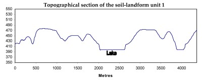
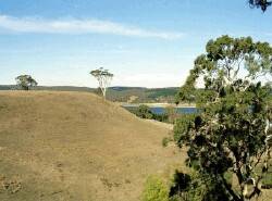 The steep slopes of this unit line the Lal Lal Reservoir. This reservoir is a major water supply of the Central Highlands |
0.20% of CMA region Hills and scarps associated with Ordovician sandstones and shales are the main landforms of this distinct unit near Lal Lal. Surrounding the Lal Lal Reservoir, this unit has a high level of remnant vegetation on these steep slopes that drain towards the reservoir. As part of the Western Uplands, this unit is significant for its vegetation but also its water catchment value for the Central Highlands. Native vegetation classes of these hills include Valley Grassy, Grassy Dry and Herb-rich Foothill Forests as well as Plains Grassy, and Grassy Woodlands. Whilst the major land use of this unit is a water supply catchment area, other land uses such as grazing and cropping also occur. Soils include red mottled yellow gradational or texture contrast soils on the slopes, shallow stony red gradational soils on crests, black gradational soils on drainage depressions and shallow brown texture contrast/gradational soils on scarps and steep slopes. The main hazards to land use are overland flow causing sheet and rill erosion, gully erosion (where subsoils are exposed) and minor compaction. | 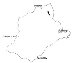 |
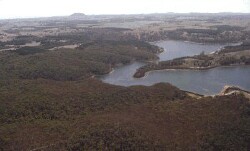 Steep slopes and scarps that line Lal Lal Reservoir. These scarps include Ordovician sediments of this unit | 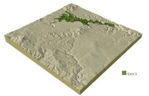 |
 | 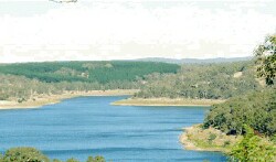 Lal Lal Reservoir |
Component | 1 | 2 | 3 | 4 | 5 | 6 |
Proportion of soil-landform unit | 3% | 34% | 2% | 31% | 20% | 10% |
| CLIMATE Rainfall (mm) | Annual: 720 | |||||
| Temperature (oC) | Minimum 7, Maximum 17 | |||||
| Precipitation less than potential evapotranspiration | November-March | |||||
| GEOLOGY Age and lithology | ||||||
| Geomorphology | ||||||
| LANDUSE | Uncleared: Nature conservation; water supply Cleared: Sheep and beef cattle grazing; softwood plantations; cropping (cereal); water supply | |||||
| TOPOGRAPHY Landscape | Steep hills and scarp beside main creek including channel | |||||
| Elevation range (m) | 303-540 | |||||
| Local relief (m) | 65 | |||||
| Drainage pattern | Dendritic | |||||
| Drainage density (km/km2) | 3.7 | |||||
| Landform | Hill | Scarps with locak rock outcrop | Creek bed | |||
| Landform element | Moist protected slopes | Dry exposed slopes | Drainage lines | Crest | Slope | Floodplain |
| Slope and range (%) | 15 (12-35) | 15 (10-25) | 3 (1-5) | 3 (1-8) | 13 (10-35) | 2 (1-5) |
| Slope shape | Straight | Straight | Concave | Convex | Convex | Straight |
| NATIVE VEGETATION Structure | Tall open forest | Open forest | Open forest | Open forest | Open forest | Open forest |
| Dominant species | E. obliqua, E. ovata, E. radiata, E. viminalis | E. obliqua, E. dives, E. radiata, E. viminalis | E, ovata, E. radiata, E. viminalis | E. obliqua, E. dives, E. radiata, E. viminalis | E. viminalis, E. ovata | E. viminalis, E. ovata |
| SOIL Parent material | In situ weathered sandstone and shale | In situ weathered sandstone and shale | Alluvium, clay, silt, sand, grvel | In situ weathered sandstone and shale | In situ weathered basalt | Unconsolidated sedimentary and in situ weathered Ordovician sediments |
| Description (Corangamite Soil Group) | Black gradational soil - variable (34) | Shallow brown texture contrast or gradational soils (37) | Black clay soil, coarse structure (31) | |||
| Soil type sites | ||||||
| Surface texture | Fine sandy loam | Fine sandy loam | Clay loam | Gravelly loam | Clay loam | Clay |
| Permeability | High | High | Moderate to low | High | High | Low |
| Depth (m) | 1 | 2 | >1 | 0.5 | 1 | 1.5 |
| LAND CHARACTERISTICS, POTENTIAL AND LIMITATIONS | Steep slopes and hardsetting surfaces can cause overland flow, and sheet and rill erosion. | Steep slopes and hardsetting surfaces can cause overland flow, and sheet and rill erosion. Soil compaction also a limitation when soils are waterlogged. | Moderate permeability soils with hardsetting surfaces. Overland flow and subsurface flow compound waterlogging and gully erosion. Soil compaction also a limitation when soils are waterlogged. | Moderate permeability soils with hardsetting surfaces. Overland flow and subsurface flow compound waterlogging and gully erosion. Soil compaction also a limitation when soils are waterlogged. | Slopes and hardsetting surfaces can cause overland flow and sheet and rill erosion. | Poorly drained site with low permeability can cause overland flow. Waterlogging along with streambank erosion and soil compaction are issues. |


