
Soil/Landform Unit - Yarriambiack/Dunmunkle Creek
Landform Unit Description
Page top
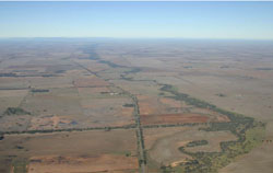 View south towards the Western Uplands along Yarriambiack Creek |
0.87% of CMA region This unit of very low relative relief terrain of floodplains and terrace plains consists of the two major tributaries Dunnmunckle Creek and Yarriambiack Creek. This alluvial complex is part of the Northern Riverine Plains modern floodplains and sits within the clay plains to the east and west, older alluvial plain, and ridge and depression terrain. The floodplain, terrace plain, prior stream channels and terrace flats all occur on these creeks. Drainage consists of concentrating flow from the plains and loses topographical expression as the streams go north. Sodic grey texture contrast soils (Sodosols) with grey cracking clay soil (Vertosols) occur on the floodplains and depressions. Inundation and waterlogging are the main land degradation issues. Land use includes dryland cropping, grazing (sheep and cattle), water supply, recreation, nature conservation, residential development and hardwood forestry. Remnant vegetation communities include Plains Savannah, Lignum Swampy Woodland, Plains Woodland, Riverine Chenopod Woodland, Ridged Plains Mallee and Low Rises Woodland. |  |
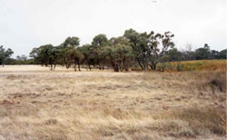
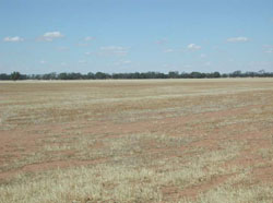 Plains on the western extent of Yarriambiack Creek | 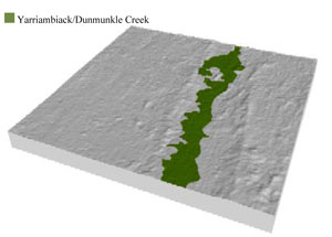 |
 |  Black box near Murtoa |
Component | 1 | 2 | 3 | 4 |
Proportion of soil-landform unit | 55% | 30% | 5% | 10% |
| CLIMATE Rainfall (mm) | Annual: 385 | |||
| Temperature (oC) | Minimum 9, Maximum 22 | |||
| Precipitation less than potential evapotranspiration | September–April | |||
| GEOLOGY Age and lithology | Quaternary fluvial silt sand and minor gravel (Shepparton Formation); Neogene marine sand and silt (Parilla Sand) | |||
| Geomorphology | ||||
| LANDUSE | Uncleared areas: water supply; nature conservation Cleared areas: water supply; dryland cropping; sheep and beef cattle grazing | |||
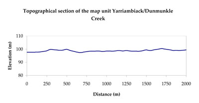
| TOPOGRAPHY Landscape | Alluvial plains | |||
| Elevation range (m) | 91–161 | |||
| Local relief (m) | 3 | |||
| Drainage pattern | Dendritic | |||
| Drainage density (km/km2) | 1.0 | |||
| Landform | Alluvial plains | |||
| Landform element | Floodplain | Terrace plain | Terrace flat | Prior stream |
| Slope and range (%) | 3 (2-6) | 2 (1-5) | 1 (0-3) | 2 (0-5) |
| Slope shape | Concave | Straight | Straight | Straight |
| NATIVE VEGETATION Ecological Vegetation Class | Riverine Chenopod Woodland (42.7%), Plains Woodland (14.9%), Plains Savannah (14.2%), Lignum Swampy Woodland (13.5%), Other (13.0%) | |||
| SOIL Parent material | Fluvial gravel, sand and silt, marine sand and silt | Alluvial gravel, and and silt | Alluvial gravel, and and silt | Alluvial gravel, sand and silt |
| Description (Corangamite Soil Group) | Sodic grey texture contrast soils (21) | Sodic grey texture contrast soils (21) | ||
| Soil type sites | ||||
| Surface texture | Sandy clay loam to medium clay | Sandy clay loam | Sandy clay loam | Sandy clay loam to medium clay |
| Permeability | Very slow | Slow | Slow | Very slow |
| Depth (m) | > 3 | > 3 | > 3 | > 3 |
| LAND CHARACTERISTICS, POTENTIAL AND LIMITATIONS Critical land features, processes, forms | Floodplains are susceptible to inundation and waterlogging. Surface soils can be susceptible to sheet and rill erosion along with compaction at critical moisture contents. Slight susceptibility of surface soil to acidification. | Terrace plains are susceptible to seasonal inundation and waterlogging. Surface soils can be susceptible to sheet and rill erosion along with compaction at critical moisture contents. Slight susceptibility of surface soil to acidification. | Flat areas susceptible to inundation and waterlogging, but can be variable due to micro relief (gilgai). Soil compaction can occur at critical moisture contents. Slight susceptibility of surface soil to acidification. | Prior stream plains are generally hardsetting (weakly structured) and experience periodic waterlogging. Surface soils can be susceptible to rill erosion during storm events. Slight susceptibility of surface soil to acidification and compaction. |
© State of Victoria (Agriculture Victoria) 1996 - .

This work, Victorian Resources Online, is licensed under a Creative Commons Attribution 4.0 licence. You are free to re-use the work under that licence, on the condition that you credit the State of Victoria (Agriculture Victoria) as author, indicate if changes were made and comply with the other licence terms.
The licence does not apply to ‘branding’ or some ‘images or photographs’ that may be owned by third parties. We ask you to seek prior approval to use images using the VRO feedback form. Access to higher quality images can also be provided on request.
This page was last updated on .