
21. Sodic, grey texture contrast soils/Modern floodplains: Meander belt below flood level
|
These soils have developed on alluvium of Recent unconsolidated material in the North West Dunefields and Plains, predominantly on the Wimmera River floodplain. This soil has a slightly acidic to neutral surface, grading to alkaline in the subsoil.
| 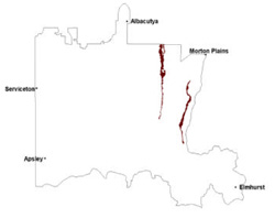 |
Soil Sites
Site code | Soil-landform unit | Component | ASC | FK | 1:100 000 mapsheet |
| WIA20 | Wimmera River | Terrace flat | Calcic, Subnatric, Grey Sodosol | Dy3.33 | T7324 - Horsham |
© State of Victoria (Agriculture Victoria) 1996 - .

This work, Victorian Resources Online, is licensed under a Creative Commons Attribution 4.0 licence. You are free to re-use the work under that licence, on the condition that you credit the State of Victoria (Agriculture Victoria) as author, indicate if changes were made and comply with the other licence terms.
The licence does not apply to ‘branding’ or some ‘images or photographs’ that may be owned by third parties. We ask you to seek prior approval to use images using the VRO feedback form. Access to higher quality images can also be provided on request.
This page was last updated on .