
Soil/Landform Unit - Wimmera River
Landform Unit Description
Page top
 Wimmera River at Dimboola |
0.84% of CMA region Alluvial plains and terrace plains of the Wimmera River extend from Horsham to Lake Hindmarsh and from Lake Hindmarsh to Lake Albacutya. Part of the Northern Riverine Plains modern floodplains (4.1), these plains sit within the older alluvial plain, dissecting the Little Desert and bound within the Lowan salt valley. There are five components, the plain being dominant and terrace plain subdominant. The other components are the terrace flats, drainage depressions and playas. Drainage consists of concentrating flow from the plains and the outwash slopes including seeps, which may be saline. Grey cracking clay soils (Vertosols) and sodic grey texture contrast soils occur on the flats. Seasonal inundation and waterlogging are the main land degradation susceptibilities of this relatively flat terrain. Land use includes grazing (sheep and cattle), dryland cropping, water supply, recreation, nature conservation, residential and hardwood forestry. Vegetation communities include a variety of woodland, mallee and shrubland vegetation such as Plains Woodland, Drainage-line Woodland, Freshwater Lignum Shrubland, Red Swale Mallee and Ridged Plains Mallee. | 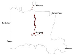 |
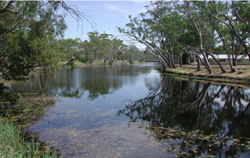
 Looking north towards the junction of the Wimmera River and Datchak Creek | 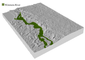 |
 | 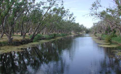 River red gums lining the Wimmera River |
Component | 1 | 2 | 3 | 4 | 5 |
Proportion of soil-landform unit | 40% | 10% | 35% | 10% | 5% |
| CLIMATE Rainfall (mm) | Annual: 410 | ||||
| Temperature (oC) | Minimum 8, Maximum 22 | ||||
| Precipitation less than potential evapotranspiration | September–April | ||||
| GEOLOGY Age and lithology | Quaternary aeolian dune sand (Lowan Sand); Neogene marine sand and silt (Parilla Sand); Quaternary paludal silt and clay | ||||
| Geomorphology | |||||
| LANDUSE | Uncleared areas: hardwood forestry for sawlogs, posts and poles; water supply; nature conservation Cleared areas: heep grazing; water supply; dryland cropping; residential development; recreational activities | ||||
| TOPOGRAPHY Landscape | River plain | ||||
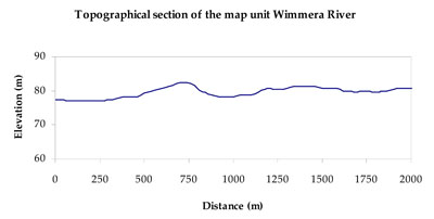
| Elevation range (m) | 74–137 | ||||
| Local relief (m) | 1 | ||||
| Drainage pattern | Dendritic | ||||
| Drainage density (km/km2) | 2.0 | ||||
| Landform | Alluvial plains | ||||
| Landform element | Plain | Terrace flat | Terrace plain | Drainage depression | Playa |
| Slope and range (%) | 2 (1-3) | 1 (0-2) | 1 (0-2) | 2 (0-3) | 1 (0-2) |
| Slope shape | Straight | Straight | Straight | Concave | Concave |
| NATIVE VEGETATION Ecological Vegetation Class | Riverine Chenopod Woodland (28.9%), Intermittent Swampy Woodland/Riverine Grassy Woodland Complex (24.8%), Riparian Woodland (14.3%), Semi-arid Woodland (6.3%), Other (25.7%) | ||||
| SOIL Parent material | Alluvial gravel, sand and silt | Alluvial gravel, sand and silt | Alluvial gravel, sand and silt | Alluvial gravel, sand and silt | Paludal silt and clay |
| Description (Corangamite Soil Group) | Cracking clay soils (22) | Sodic grey texture contrast soils (21) | Cracking clay soils (22) | Cracking clay soils (22) | |
| Soil type sites | |||||
| Surface texture | Medium clay | Sandy clay loam | Sandy clay loam to medium clay | Medium clay | Medium clay |
| Permeability | Very slow | Slow | Very slow | Very slow | Very slow |
| Depth (m) | > 2 | > 3 | > 2 | > 2 | > 2 |
| LAND CHARACTERISTICS, POTENTIAL AND LIMITATIONS Critical land features, processes, forms | Plains are susceptible to inundation, waterlogging and flood events. Surface soils are susceptible to compaction (less structure) where moisture content is critical. | Flat areas susceptible to inundation and waterlogging. Surface soils can be susceptible to sheet and rill erosion along with compaction at critical moisture contents. Slight susceptibility of surface soil to acidification. | Terrace plains are susceptible to inundation and waterlogging. Surface soils can be susceptible to sheet and rill erosion along with compaction at critical moisture contents. Slight susceptibility of surface soil to acidification. | Flat areas are subject to seasonal inundation, waterlogging and flooding. Subsoils are sodic and extremely vulnerable to gully erosion where exposed. Surface compaction occurs at critical moisture contents. | Playa plains are subject to seasonal inundation, waterlogging and flooding. Subsoils are sodic and extremely vulnerable to gully erosion where exposed. Surface compaction occurs at critical moisture contents. |
© State of Victoria (Agriculture Victoria) 1996 - .

This work, Victorian Resources Online, is licensed under a Creative Commons Attribution 4.0 licence. You are free to re-use the work under that licence, on the condition that you credit the State of Victoria (Agriculture Victoria) as author, indicate if changes were made and comply with the other licence terms.
The licence does not apply to ‘branding’ or some ‘images or photographs’ that may be owned by third parties. We ask you to seek prior approval to use images using the VRO feedback form. Access to higher quality images can also be provided on request.
This page was last updated on .