
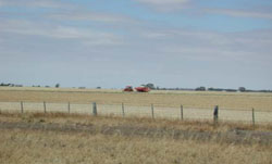
Soil/Landform Unit - Murra Warra East gentle rises
 Red soils east of the Yarriambiack Creek are often on gentle to undulating rises |
2.66% of CMA region The landscape comprises large and some small discreet depositional entities that form the lower part of an extensive plains complex south-east of Warracknabeal and north-east of Murtoa. As part of North West Dunefields and Plains; clay plains with subdued ridges unit (5.4), the extensive alluvial (and aeolian) plains of Quaternary sediments with occasional rises is bound by the Yarriambiack Creek to the west, and subdued dunefields (Beulah) and alluival plains (Charlton) to the north. To the south and east lie a plains complex with alluvial and paludal plains. Dunmunkle Creek flowing south to north dissects the unit. Drainage is mainly dendritic and extensive away from the main drainage lines, which may be anastomotic. Site drainage is generally slow. Soils include red sodic texture contrast soils (Sodosols) and grey cracking clay soils (Vertosols). Hardsetting surfaces are common where exposed. Broadacre dryland cropping is the major enterprise with minor grazing (sheep and cattle). Plains Savannah and Plains Woodland are the most expansive remnant vegetation communities recorded. | 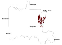 |
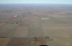
 Bean crop on gently undulating rises and plains | 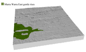 |
 |  Cereal harvesting |
Component | 1 | 2 |
Proportion of soil-landform unit | 95% | 5% |
| CLIMATE Rainfall (mm) | Annual: 390 | |
| Temperature (oC) | Minimum 9, Maximum 21 | |
| Precipitation less than potential evapotranspiration | September–April | |
| GEOLOGY Age and lithology | Quaternary fluvial silt, sand and minor gravel (Shepparton Formation); Neogene marine sand and silt (Parilla Sand); Quaternary paludal silt and clay | |
| Geomorphology | ||
| LANDUSE | Uncleared areas: nature conservation Cleared areas: dryland cropping; sheep and beef cattle grazing | |
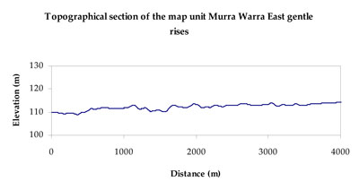
| TOPOGRAPHY Landscape | Moderately undulating plains | |
| Elevation range (m) | 104–153 | |
| Local relief (m) | 3 | |
| Drainage pattern | Dendritic | |
| Drainage density (km/km2) | 0.4 | |
| Landform | Undulating plains | |
| Landform element | Plain | Playa |
| Slope and range (%) | 2 (1-5) | 1 (0-3) |
| Slope shape | Straight | Concave |
| NATIVE VEGETATION Ecological Vegetation Class | Plains Savannah (42.2%), Plains Woodland (31.6%), Low Rises Woodland (11.3%), Ridged Plains Mallee (8.5%), Other (3.0%) | |
| SOIL Parent material | Marine sand and silt | Paludal silt and clay |
| Description (Corangamite Soil Group) | Cracking clay soils (34) | |
| Soil type sites | ||
| Surface texture | Sandy loam to medium clay | Medium clay |
| Permeability | Moderate to slow | Slow |
| Depth (m) | > 3 | > 3 |
| LAND CHARACTERISTICS, POTENTIAL AND LIMITATIONS Critical land features, processes, forms | Hardsetting surfaces susceptible to sheet and rill erosion. High clay content results in restricted soil drainage. Soils are prone to compaction at critical moisture contents. Clay surface soils are friable and only slightly susceptible to wind erosion due to self-mulching and massive nature | High clay content results in restricted soil drainage, but can be variable due to micro relief (gilgai). Plain may be subject to periodic inundation and waterlogging. Surface soils are friable and only slightly susceptible to wind erosion due to self-mulching and massive nature. Soils may be susceptible at critical moisture contents and have variable resilience to compaction. |
© State of Victoria (Agriculture Victoria) 1996 - .

This work, Victorian Resources Online, is licensed under a Creative Commons Attribution 4.0 licence. You are free to re-use the work under that licence, on the condition that you credit the State of Victoria (Agriculture Victoria) as author, indicate if changes were made and comply with the other licence terms.
The licence does not apply to ‘branding’ or some ‘images or photographs’ that may be owned by third parties. We ask you to seek prior approval to use images using the VRO feedback form. Access to higher quality images can also be provided on request.
This page was last updated on .