
WIA5
|
| WIA5 | 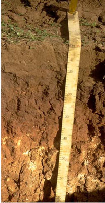 Endocalcareous-Endohypersodic, Self-mulching, Red Vertosol | |
|
Location | Coromby, western Victoria | |||
|
Landform | Plain | |||
|
Geology | Pliocene Parilla Sand: marine sand and silt | |||
|
Element | Plain | |||
|
Slope | 0-1% | |||
Horizon | Depth (cm) | Description | ||
A1 | 0–10 | Brown (10YR4/3); light clay; subplastic; cracking and self-mulching surface condition; weak coarse granular structure; weak consistence dry; pH 8.8; sharp and smooth boundary to: | ||
B21 | 10–30 | Reddish brown (5YR4/4); medium clay; plastic; strong very coarse prismatic structure; very strong consistence dry; sticky consistence wet; pH 9.1; clear and smooth boundary to: | ||
B22k | 30–65 | Yellowish red (5YR4/5) with fine faint (7.5YR6/6) mottles; light clay; subplastic; weak coarse subangular blocky structure; strong consistence dry; sticky consistence wet; few (2-10%) soft carbonate segregations; pH 9.3. | ||
B23k | 65–100 | Yellowish red (5YR4/5) with faint (7.5YR6/6) mottles; heavy clay; subplastic; weak coarse subangular blocky structure; strong consistence dry; sticky consistence wet; few (2-10 %) soft carbonate segregations; pH 9.1. | ||
B24k | 100–145 | Yellowish red (5YR4/5) with fine faint (7.5YR6/6) mottles; heavy clay; subplastic; weak coarse subangular blocky structure; strong consistence dry; sticky consistence wet; few (2-10%) soft carbonate segregations; pH 8.9; gradual boundary to: | ||
B31 | 145–180 | Brown (7.5YR5/5); medium clay; weak coarse subangular blocky structure; pH 8.9; gradual boundary to: | ||
B32 | 180–215 | Strong brown (7.5YR5/6) with (10YR6/3) mottles; medium clay; weak coarse subangular blocky structure; pH 8.9. | ||
| Management considerations | ||||
| ||||
Site WIA5 | Sample depth cm | pH | EC dS/m | NaCl % | Ex Ca cmol-/kg | Ex Mg cmol-/kg | Ex K cmol-/kg | Ex Na cmol-/kg | Ex Al mg/kg | Ex acidity cmol-/kg | FC -30okPa | PWP -1500okPa | KS % | FS % | Z % | C % | |
Horizon | H2O | CaCl2 | |||||||||||||||
A1 | 0–10 | 8.8 | NA | 0.18 | 0.01 | 19.5 | 4 | 2.1 | 1 | NA | 1.2 | 25.8 | 14.7 | 25 | 22 | 8 | 44 |
B21 | 10–30 | 9.1 | NA | 0.22 | 0.03 | 15.6 | 9.7 | 1.8 | 4.7 | NA | NA | NA | 24.9 | 19 | 18 | 5 | 57 |
B22k | 30–65 | 9.3 | NA | 0.75 | 0.07 | 10.2 | 13.8 | 1.9 | 8.8 | NA | NA | NA | 33.3 | 18 | 15 | 3 | 57 |
B23k | 65–100 | 9.1 | NA | 1.6 | 0.17 | 6.9 | 12.9 | 2 | 12.7 | NA | NA | NA | 26.2 | 13 | 14 | 8 | 58 |
B24k | 100–145 | 8.9 | NA | 2 | 0.24 | 7.5 | 15.9 | 2.2 | 14.1 | NA | NA | NA | 27.1 | 10 | 9 | 7 | 58 |
B31 | 145–180 | 8.9 | NA | 2.01 | 0.27 | NA | NA | NA | NA | NA | NA | NA | NA | 12 | 15 | 8 | 65 |
B32 | 180–215 | 8.9 | NA | 2 | 0.31 | NA | NA | NA | NA | NA | NA | NA | NA | 9 | 11 | 8 | 59 |
© State of Victoria (Agriculture Victoria) 1996 - .

This work, Victorian Resources Online, is licensed under a Creative Commons Attribution 4.0 licence. You are free to re-use the work under that licence, on the condition that you credit the State of Victoria (Agriculture Victoria) as author, indicate if changes were made and comply with the other licence terms.
The licence does not apply to ‘branding’ or some ‘images or photographs’ that may be owned by third parties. We ask you to seek prior approval to use images using the VRO feedback form. Access to higher quality images can also be provided on request.
This page was last updated on .