
Soil/Landform Unit - Mount William Creek
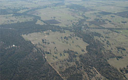 Mount William Creek at Dadswells Bridge before anabranching into the Wimmera River |
0.57% of CMA region This unit consists of a few large and some small discreet depositional entities that form the lower part of the Mt William Creek alluvial sequence. Dividing the Grampians Ranges to the west from the Dissected Uplands to the east, this extensive alluvial unit of Quaternary sediments abuts colluvial sediments (Grampians Plains) to the west, the Wimmera River to the north and other sedimentary and volcanic rock units (e.g. Mt Dryden, Mokepilly) to the east. Alluvial flats and footslopes, plains, anastomotic plains and drainage lines, and bordering dunes are all present. Drainage is mainly dendritic and extensive away from the main drainage lines, which may be anastomotic. Site drainage is generally slow. Soils are predominantly yellow and brown gradational (Dermosols) and texture contrast soils (Chromosols) with yellow, brown and grey sodic texture contrast soils (Sodosols) occurring on poorly drained areas. Sheet and rill susceptibility is associated with the lighter top soils, while dunes are susceptible to wind erosion also. Seasonal inundation is likely in lower areas. Grazing (sheep and cattle) is the major enterprise. Woodlands such as Plains Grassy Woodland, Heathy Woodland, Creekline Grassy Woodland, Grassy Woodland, Plains Woodland and Shrubby Woodland are the most common remnant vegetation found. | 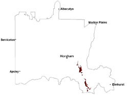 |
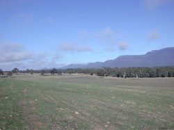 Hillslopes leading to Mount William Creek | 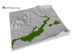 |
 | 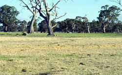 Sandy undulations within the alluvial floodplain |
Component | 1 | 2 | 3 | 4 |
Proportion of soil-landform unit | 25% | 5% | 60% | 10% |
| CLIMATE Rainfall (mm) | Annual: 580 | |||
| Temperature (oC) | Minimum 8, Maximum 20 | |||
| Precipitation less than potential evapotranspiration | October–April | |||
| GEOLOGY Age and lithology | Quaternary fluvial silt, sand and minor gravel; Cambrian ‘greenstone’ - basalt, andesite, boninite, rhyolite, gabbro, lithic sandstone, chert, shale and breccia | |||
| Geomorphology | ||||
| LANDUSE | Uncleared areas: water supply; nature conservation Cleared areas: sheep and beef cattle grazing; dryland cropping; water supply; sand extraction | |||
| TOPOGRAPHY Landscape | Alluvial plain | |||
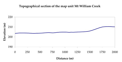
| Elevation range (m) | 141–285 | |||
| Local relief (m) | 2 | |||
| Drainage pattern | Dendritic | |||
| Drainage density (km/km2) | 1.5 | |||
| Landform | Plains | Low dunes | Alluvial plains | |
| Landform element | Plain | Dune | Alluvial flat and footslope | Anastomotic plain and drainage line |
| Slope and range (%) | 4 (1-7) | 5 (2-9) | 1 (0-2) | 1 (0-2) |
| Slope shape | Straight | Convex | Straight | Straight |
| NATIVE VEGETATION Ecological Vegetation Class | Plains Grassy Woodland (22.0%), Creekline Grassy Woodland (19.7%), Red Gum Wetland (14.2%), Plains Woodland (8.6%), Other (33.1%) | |||
| SOIL Parent material | Fluvial gravel, sand and silt | Aeolian dune sand | Alluvial gravel, sand and silt | Alluvial gravel, sand and silt |
| Description (Corangamite Soil Group) | Yellow and brown gradational and texture contrast soils (11) | Sandy gradational soils (14) | ||
| Soil type sites | GRAMP335 | |||
| Surface texture | Loamy sand | Sandy loam | Loam, fine sandy to loamy sand | Sany loam to clay loam |
| Permeability | Moderate to high | High | Slow | Slow to very slow |
| Depth (m) | > 2 | > 2 | > 2 | > 2 |
| LAND CHARACTERISTICS, POTENTIAL AND LIMITATIONS Critical land features, processes, forms | Lighter surface susceptible to sheet and rill erosion and compaction. Subsoil susceptible to rill and gully erosion where sodic and deeper. Lighter variants are well drained. | Light sandy soils generally rapidly drained. Weakly coherent surfaces with little organic matter are susceptible to sheet and wind erosion where exposed. Acidic soils with low inherent fertility. | Lighter surface susceptible to sheet and rill erosion and compaction. Subject to periodic inundation and waterlogging, especially during flood events. Lighter soil variants are well drained. Upper soil susceptible to acidification. | Soil surface susceptible to compaction. Subject to periodic inundation and waterlogging, especially during flood events. Lighter soil variants are well drained. Upper soil susceptible to acidification. |
© State of Victoria (Agriculture Victoria) 1996 - .

This work, Victorian Resources Online, is licensed under a Creative Commons Attribution 4.0 licence. You are free to re-use the work under that licence, on the condition that you credit the State of Victoria (Agriculture Victoria) as author, indicate if changes were made and comply with the other licence terms.
The licence does not apply to ‘branding’ or some ‘images or photographs’ that may be owned by third parties. We ask you to seek prior approval to use images using the VRO feedback form. Access to higher quality images can also be provided on request.
This page was last updated on .