
Soil/Landform Unit - Landsborough footslopes
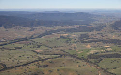 Looking south-east along the Landsborough–Elmhurst Road. Footslopes are especially evident where land has been cleared downslope from the steeper slopes of the Pyrenees Ranges. |
0.49% of CMA region Footslopes that line steep slopes of the Pyrenees Ranges are characterised by higher moderate slopes over lower gentle slopes and alluvial plains (flats). Forming part of the plateaux and rises of residual Cainozoic landscapes of the Dissected Western Uplands, the footslopes may include significant gravel and sand deposits that have resulted in deep weathering (ferruginisation/silicification/kaolinisation) of underlying Palaeozoic bedrock. Red and yellow texture contrast soils (Chromosols) are common on footslopes with sodic brown, yellow and grey texture contrast soils (Sodosols) found on alluvial flats. Soils are friable with better infiltration in moister areas and occasional hardsetting soil surfaces. Land use of these footslopes is dominated by viticulture and grazing. Remnant forest and woodland areas dominate vegetation. Heathy Dry Forest and Grassy Dry Forest are found in exposed areas of the landscape while Herb-rich Foothill Forest and Valley Grassy Forest are found in more sheltered areas, or in areas at higher altitudes. Other vegetation communities present include Box Ironbark Forest, Creekline Grassy Woodland, Plains Woodland and Grassy Woodland. | 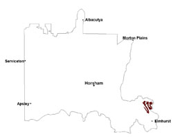 |
 Footslopes near Glenlofty | 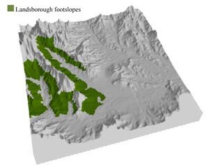 |
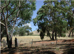
 | 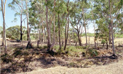 Roadside remnant vegetation wth a vineyard in teh background |
Component | 1 | 2 | 3 |
Proportion of soil-landform unit | 10% | 80% | 10% |
| CLIMATE Rainfall (mm) | Annual: 650 | ||
| Temperature (oC) | Minimum 7, Maximum 19 | ||
| Precipitation less than potential evapotranspiration | October–April | ||
| GEOLOGY Age and lithology | Neogene gravel, sand and silt; Quaternary silt, sand and minor gravel (Shepparton Formation); Quaternary gravel, sand and silt | ||
| Geomorphology | |||
| LANDUSE | Uncleared areas: nature conservation; water supply Cleared areas: dryland cropping; sheep grazing | ||
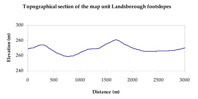
| TOPOGRAPHY Landscape | Footslopes | ||
| Elevation range (m) | 219–444 | ||
| Local relief (m) | 15–20 | ||
| Drainage pattern | Dendritic | ||
| Drainage density (km/km2) | 1.1 | ||
| Landform | Hillslopes (Landsborough 3) | Lower footslopes and plains (Landsborough 2) | |
| Landform element | Moderate slope/footslope | Gentle lower footslope | Alluvial flat |
| Slope and range (%) | 12 (10-32) | 3 (1-12) | 2 (1-6) |
| Slope shape | Convex | Concave | Concave |
| NATIVE VEGETATION Ecological Vegetation Class | Box Ironbark Forest (21.2%), Alluvial Terraces Herb-rich Woodland (16.9%), Grassy Woodland/Alluvial Terraces Herb-rich Woodland Mosaic (14.3%), Heathy Dry Forest (11.3%), Grassy Dry Forest (11.3%), Other (24.2%) | ||
| SOIL Parent material | In situ marine sandstone, siltstone and biotite schist | Fluvial gravel, sand and silt | Alluvial gravel, sand and silt |
| Description (Corangamite Soil Group) | Red texture contrast soils (1) | Sodic brown, yellow and grey texture contrast soils (12) | |
| Soil type sites | |||
| Surface texture | Fine sandy loam | Fine sandy loam to silty loam | Loam, fine sandy (heavy) |
| Permeability | Moderate | Moderate to slow | Moderate |
| Depth (m) | 0.7 | 1.4 | > 2 |
| LAND CHARACTERISTICS, POTENTIAL AND LIMITATIONS Critical land features, processes, forms | Friable with better infiltration in moister areas, hardsetting and more prone to sheet and rill erosion in drier areas (north and westerly aspects). Susceptible to acidification in wetter areas. | Soils are friable with better infiltration in moister areas. Hardsetting surfaces are more prone to sheet and rill erosion in drier areas (including drier aspects). Sodic subsoil prone to gully and tunnel erosion. Susceptible to acidification in wetter areas. | Lighter surfaces susceptible to sheet and rill erosion and compaction, especially where organic matter levels are low. Subsoil susceptible to rill and gully erosion where sodic, deeper and on sloping terrain. Lighter variants are well drained. Upper soil susceptible to acidification. |
© State of Victoria (Agriculture Victoria) 1996 - .

This work, Victorian Resources Online, is licensed under a Creative Commons Attribution 4.0 licence. You are free to re-use the work under that licence, on the condition that you credit the State of Victoria (Agriculture Victoria) as author, indicate if changes were made and comply with the other licence terms.
The licence does not apply to ‘branding’ or some ‘images or photographs’ that may be owned by third parties. We ask you to seek prior approval to use images using the VRO feedback form. Access to higher quality images can also be provided on request.
This page was last updated on .