
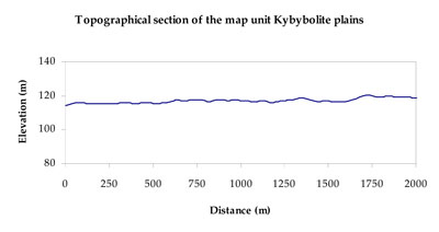
Soil/Landform Unit - Kybybolite plains
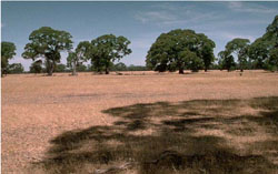 Plains near the Victoria-South Australia border |
0.17% of CMA region Located on the border of Victoria and South Australia, these gently undulating plains comprise gentle rise crests and plains of flats and slopes. Lining western extents of the Tallageira soil-landform unit, the plains form part of the low ridge tops with remnant aeolian sands and orientated swales with lakes and lunettes (5.5.2) geomorphology sequence. Soils of the plains are sodic brown, yellow and grey texture contrast soils (Sodosols) with varying depths of surface sand. These sandy surfaces maybe susceptible to wind and sheet erosion where exposed. The strong texture contrast with loose sands over clays has implications for site drainage also. This is reflected in irrigated horticulture where vegetables etc. are grown on these sandy soils and applied waters are recaptured through a series of shallow drains. These drains are usually dug to the top of the subsoil where water infiltration is extremely slow. The dominant vegetation communities are Plains Woodland, Red Gum Wetland, Shallow Sands Woodland and Red Gum/Aquatic Herbland Mosaic. Other vegetation present includes Damp Sand Herb-rich Woodland, Heathy Woodland and Drainage-line Woodland. | 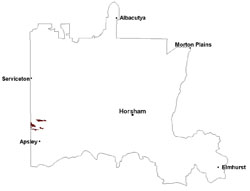 |
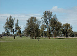 Red gum and allcasuarine trees on a plain near Tallageira | 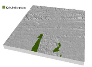 |
 | 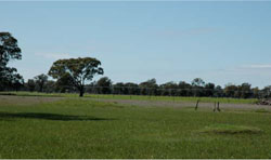 Centre pivot irrigator on a cleared undulating rise near Tallageira |
Component | 1 | 2 |
Proportion of soil-landform unit | 90% | 10% |
| CLIMATE Rainfall (mm) | Annual: 560 | |
| Temperature (oC) | Minimum 8, Maximum 21 | |
| Precipitation less than potential evapotranspiration | October–April | |
| GEOLOGY Age and lithology | Quaternary paludal silt and clay; Neogene marine sand and silt (Parilla Sand) | |
| Geomorphology | ||
| LANDUSE | Uncleared areas: nature conservation Cleared areas: dryland cropping; sheep grazing | |
| TOPOGRAPHY Landscape | Gently undulating plains | |
| Elevation range (m) | 96–132 | |
| Local relief (m) | 2 | |
| Drainage pattern | Dendritic–deranged | |
| Drainage density (km/km2) | 0.2 | |
| Landform | Plains | Rises |
| Landform element | Flat/gentle slope | Rise slope/crest |
| Slope and range (%) | 3 (1-7) | 5.(2-9) |
| Slope shape | Straight | Convex |
| NATIVE VEGETATION Ecological Vegetation Class | Plains Woodland (60.4%), Red Gum Wetland (20.5%), Shallow Sands Woodland (8.4%), Other (9.2%) | |
| SOIL Parent material | Marine sand and silt | Marine sand and silt |
| Description (Corangamite Soil Group) | Sodic brown, yellow and grey texture contrast soils (38) | Sodic brown, yellow and grey texture contrast soils (38) |
| Soil type sites | LSWW11, LSWW17, LSWW13 | LSWW11, LSWW17, LSWW13 |
| Surface texture | Loamy sand | Loamy sand |
| Permeability | Moderate | Moderate |
| Depth (m) | > 1.5 | 1.3 |
| LAND CHARACTERISTICS, POTENTIAL AND LIMITATIONS Critical land features, processes, forms | Susceptible to wind and sheet erosion where exposed. Susceptible to compaction where hardsetting and restricted drainage. Strong texture contrast with loose sands over clays has implications for site drainage. | Susceptible to wind and sheet erosion on slopes where exposed. Susceptible to compaction where hardsetting and restricted drainage. Upper soil is susceptible to acidification. |
© State of Victoria (Agriculture Victoria) 1996 - .

This work, Victorian Resources Online, is licensed under a Creative Commons Attribution 4.0 licence. You are free to re-use the work under that licence, on the condition that you credit the State of Victoria (Agriculture Victoria) as author, indicate if changes were made and comply with the other licence terms.
The licence does not apply to ‘branding’ or some ‘images or photographs’ that may be owned by third parties. We ask you to seek prior approval to use images using the VRO feedback form. Access to higher quality images can also be provided on request.
This page was last updated on .