
Soil/Landform Unit - Jerro eroded ridges and slopes
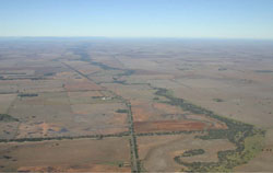 |
0.75% of CMA region Alligned north-south as part of a stranded beach ridge, this unit falls either side of the Yarriambiack Creek that also runs north-south. As part of the North West Dunefields and Plains, eroded ridges crests and slopes as well as gentle plains are major landscape components of this unit. Land use is mainly cereal cropping with soils consisting of self-mulching Vertosols along with sodic texture contrast soils especially on eroded ridge crests and slopes. The hardsetting surfaces of these red Sodosols are susceptible to sheet and rill erosion along with wind erosion, and importantly are prone to compaction at critical moisture contents. The ridges and slopes are dominated by woodland and mallee vegetation including Low Rises Woodland, Heathy Mallee, Ridged Plains Mallee, Riverine Chenopod Woodland, Plains Woodland and Lignum Swampy Woodland. Sandstone Ridge Shrubland and Parilla Mallee are associated with the sandstone ridges and rises, while Plains Savannah vegetation is associated with clay soils on gentle slopes. | 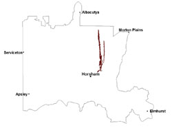 |
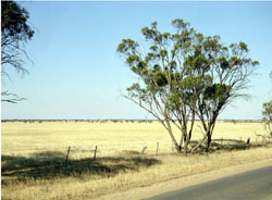 Looking downslope from upper slopes of the eroded ridge | 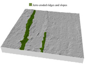 |
 | 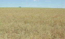 Canola on slopes of the eroded ridge |
Component | 1 | 2 | 3 | 4 |
Proportion of soil-landform unit | 40% | 5% | 35% | 20% |
| CLIMATE Rainfall (mm) | Annual: 395 | |||
| Temperature (oC) | Minimum 8, Maximum 22 | |||
| Precipitation less than potential evapotranspiration | September–April | |||
| GEOLOGY Age and lithology | Quaternary alluvium, gravel, sand and silt; Neogene marine sand and silt (Parilla Sand); Quaternary paludal silt and clay | |||
| Geomorphology | ||||
| LANDUSE | Uncleared areas: nature conservation Cleared areas: dryland cropping; sheep grazing; gravel extraction (including mineral sands) | |||
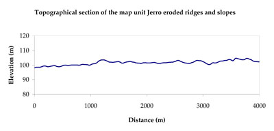
| TOPOGRAPHY Landscape | Eroded ridges and slopes | |||
| Elevation range (m) | 97–150 | |||
| Local relief (m) | 5 | |||
| Drainage pattern | Dendritic | |||
| Drainage density (km/km2) | 0.6 | |||
| Landform | Gentle plains and alluvial plains | Eroded ridges and slopes | ||
| Landform element | Plain | Drainage line | Low rise slope | Broad eroded ridge crest |
| Slope and range (%) | 2 (1-5) | 1 (0-3) | 4 (2-7) | 3 (1-4) |
| Slope shape | Straight | Concave | Linear | Convex |
| NATIVE VEGETATION Ecological Vegetation Class | Plains Woodland (21.0%), Low Rises Woodland (20.3%), Plains Savannah (20.2%), Ridged Plains Mallee (19.9%), Other (14.3%) | |||
| SOIL Parent material | Fluvial sand, silt and clay, marine sand and silt | Alluvial sand, silt and clay | Marine sand and silt, fluvial sand, silt and clay | Marine sand and silt, fluvial sand, silt and clay |
| Description (Corangamite Soil Group) | Cracking clay soils (34) | Cracking clay soils (34) | Sodic red texture contrast soils (27) | Cracking clay soils (34) |
| Soil type sites | ||||
| Surface texture | Medium clay | Medium clay | Sandy loam | Medium clay |
| Permeability | Moderate | Moderate | Moderate | Moderate |
| Depth (m) | > 3 | > 3 | > 1.5 | > 3 |
| LAND CHARACTERISTICS, POTENTIAL AND LIMITATIONS Critical land features, processes, forms | High clay content results in restricted soil drainage, but can be variable due to micro relief (gilgai). Surface soils are friable and only slightly susceptible to wind erosion due to self-mulching and massive nature. Soils may be susceptible at critical moisture contents and have variable resilience to compaction. | High clay content results in restricted soil drainage, but can be variable due to micro relief (gilgai). Soils may be susceptible to inundation and waterlogging. Surface soils are friable and only slightly susceptible to wind erosion due to self-mulching and massive nature. Soils may be susceptible at critical moisture contents and have variable resilience to compaction. | Hardsetting surface susceptible to sheet and rill erosion along with wind erosion. Dispersive and deep subsoils susceptible to gully erosion on steeper slopes. Soils are prone to compaction at critical moisture contents. | High clay content results in restricted soil drainage, but can be variable due to micro relief (gilgai). Surface soils are friable and only slightly susceptible to wind erosion due to self-mulching and massive nature. Soils may be susceptible at critical moisture contents and have variable resilience to compaction. |
© State of Victoria (Agriculture Victoria) 1996 - .

This work, Victorian Resources Online, is licensed under a Creative Commons Attribution 4.0 licence. You are free to re-use the work under that licence, on the condition that you credit the State of Victoria (Agriculture Victoria) as author, indicate if changes were made and comply with the other licence terms.
The licence does not apply to ‘branding’ or some ‘images or photographs’ that may be owned by third parties. We ask you to seek prior approval to use images using the VRO feedback form. Access to higher quality images can also be provided on request.
This page was last updated on .