
Soil/Landform Unit - Grampians ranges
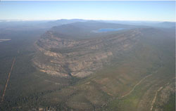 Wartook syncline and dipping sandstone strike ridges of the Mount Difficult Range |
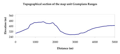
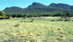
1.72% of CMA region The Grampians Ranges (named by Major Thomas Mitchell in 1836 after the hills in Scotland) consist of sandstone ridges that extend for nearly 90 kilometres along a north-south axis with Mt Zero at the northern end. Varying in elevation from 450 metres to over 1100 metres at Mt William, the ranges are the topographically most pronounced landscape in the Wimmera CMA region owing to steep gradients of cuesta landforms. The cuestas face eastwards with dip slopes to the west and scree slopes on the east. Distinctive in form, the Grampians Ranges are home to a national park with a wide diversity of flora and fauna. Associated with the dip slopes are shallow to weakly developed sandy soils (Tenosols & Rudosols) while scree slopes have deeper sandy gradational soils that may/may not have associated pans (Podosols). Drainage depressions and lines have variable concentrations of sand and silt resulting in a mix of heavy to light soil variants. Light sandy surfaces are subject to mass movement on very steep slopes when exposed. Soils are generally rapidly drained with weakly coherent surfaces with little organic matter and low inherent fertility. Flora for the ranges includes a number of woodland, forest, shrubland and heathland vegetation communities including Lowland Forest, Heathy Dry Forest, Rocky Outcrop Shrubland and Heathy Woodland for example. | 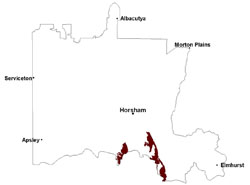 |
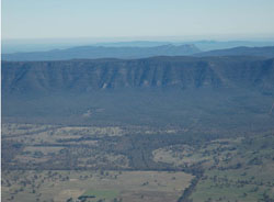 Eastern slopes of the Grampians Ranges with prominent strike ridges | 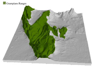 |
 |  Stacked Grampioans sandstone near Pomonal |
Component | 1 | 2 | 3 | 4 |
Proportion of soil-landform unit | 55% | 20% | 15% | 10% |
| CLIMATE Rainfall (mm) | Annual: 860 | |||
| Temperature (oC) | Minimum 7, Maximum 19 | |||
| Precipitation less than potential evapotranspiration | November–March | |||
| GEOLOGY Age and lithology | Silurian fluvial marine sandstone, siltstone, minor conglomerate; Quaternary ‘gully’ alluvium, colluvium, gravel, sand and silt; Devonian granite | |||
| Geomorphology | ||||
| LANDUSE | Uncleared areas: Water supply; nature conservation; recreational activities Cleared areas: Residential development; water supply; nature conservation; recreational activities | |||
| TOPOGRAPHY Landscape | Cuesta | |||
| Elevation range (m) | 181–1163 | |||
| Local relief (m) | >300 | |||
| Drainage pattern | Dendritic | |||
| Drainage density (km/km2) | 1.1 | |||
| Landform | Mountains | |||
| Landform element | Steep-very steep mountain slope | Moderate mountain slope | Scree slope | Drainage line |
| Slope and range (%) | 45(25-70) | 12(3-25) | 25(10-50) | 8(3-20) |
| Slope shape | Straight | Convex | Concave | Concave |
| NATIVE VEGETATION Ecological Vegetation Class | Rocky Outcrop Herbland (26.0%), Rocky Outcrop Shrubland (12.7%), Rocky Outcrop Shrubland/Rocky Outcrop Herbland Mosaic (9.0%), Heathy Dry Forest (8.5%), Heathy Woodland (6.5%), Other (36.0%) | |||
| SOIL Parent material | In situ sandstone, siltstone and conglomerates | In situ sandstone, siltstone and conglomerates | Colluvial sand, silt and gravel | In situ sandstone, siltstone and conglomerates, alluvial sand and silt |
| Description (Corangamite Soil Group) | Shallow and sandy weakly developed soils (13) | Shallow and sandy weakly developed soils (13) | Sandy gradational soils (14) | Sandy gradational soils (14) |
| Soil type sites | WLRA54, GRAMP lith | WLRA54, GRAMP lith | GRAMP335 | GRAMP335 |
| Surface texture | Loamy sand | Loamy sand | Sandy loam | Sandy loam |
| Permeability | High | High | High | High |
| Depth (m) | < 0.5 | 0.5 | 2 | 0 - 2 |
| LAND CHARACTERISTICS, POTENTIAL AND LIMITATIONS Critical land features, processes, forms | Light sandy soils subject to mass movement on very steep slopes, generally rapidly drained. Weakly coherent surfaces with little organic matter are susceptible to sheet and wind erosion where exposed . Acidic soils with low inherent fertility. | Light sandy soils subject to mass movement on steep slopes, generally rapidly drained. Weakly coherent surfaces with little organic matter are susceptible to sheet and wind erosion where exposed . Acidic soils with low inherent fertility. | Light sandy soils subject to mass movement (creep and sheet flow) on scree slopes, generally rapidly drained to hardpan or rock. Weakly coherent surfaces with little organic matter are susceptible to sheet and wind erosion where exposed . Acidic soils with low inherent fertility. Soils are slightly susceptible to further acidification. | Light sandy soils generally rapidly drained to hardpan or rock with variable soil depth. Weakly coherent surfaces with little organic matter are prone to sheet and gully erosion . Acidic soils with low inherent fertility. |
© State of Victoria (Agriculture Victoria) 1996 - .

This work, Victorian Resources Online, is licensed under a Creative Commons Attribution 4.0 licence. You are free to re-use the work under that licence, on the condition that you credit the State of Victoria (Agriculture Victoria) as author, indicate if changes were made and comply with the other licence terms.
The licence does not apply to ‘branding’ or some ‘images or photographs’ that may be owned by third parties. We ask you to seek prior approval to use images using the VRO feedback form. Access to higher quality images can also be provided on request.
This page was last updated on .