
Soil/Landform Unit - Douglas lakes and lunettes
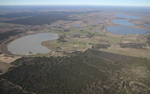 Looking south down the Douglas Depression with Lake Copper Colour (kidney shaped lake to left), North Lake, Central Lake and White Lake the major lakes further south |
0.25% of CMA region Within the Douglas Depression are a number of lakes and lunettes that vary from saline to freshwater in nature. As part of the salt lake depression of the North Western Dunefields and Plains, the soils of the lakes and lunettes include seasonally wet soils that are sodic yellow and grey texture contrast (Hydrosols) in lakes and grey to brown cracking clay soils (Vertosols) on plains and lunettes. The soils are very susceptible to seasonal inundation and waterlogging. Cracking clay soils have friable surfaces that can be vulnerable to compaction at critical moisture contents. Land use on these playa plain complexes is dryland cropping and grazing, while nature conservation is also a major use owing to high salinity levels and seasonally wet states. There are a number of woodland vegetation communities including Heathy Woodland, Low Rises Woodland, Lignum Swampy Woodland, Plains Woodland and Salt Paperbark Woodland. Other vegetation communities include Ridged Plains Mallee, Samphire Shrubland, Red Gum Wetland, Plains Savannah, Saline Lake Mosaic and Inland Saltmarsh. | 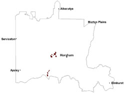 |
 Looking north up the Douglas Depression towards Mt Arapiles | 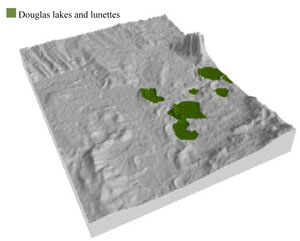 |
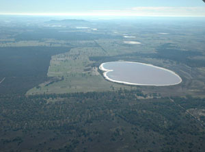
 | 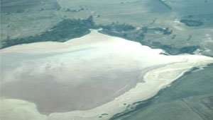 Saline lake within the Douglas Depression |
Component | 1 | 2 |
Proportion of soil-landform unit | 70% | 30% |
| CLIMATE Rainfall (mm) | Annual: 460 | |
| Temperature (oC) | Minimum 8, Maximum 21 | |
| Precipitation less than potential evapotranspiration | October–April | |
| GEOLOGY Age and lithology | Quaternary paludal silt and clay; Quaternary fluvial silt, sand and minor gravel (Shepparton Formation); Quaternary aeolian dune sand (Lowan Sand) | |
| Geomorphology | ||
| LANDUSE | Uncleared areas: nature conservation; water supply Cleared areas: sheep grazing; water supply | |
| TOPOGRAPHY Landscape | Lake and lunettes | |
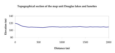
| Elevation range (m) | 104–174 | |
| Local relief (m) | 0–1 | |
| Drainage pattern | Centripetal–dendrtic | |
| Drainage density (km/km2) | 1.3 | |
| Landform | Lake and lunettes | |
| Landform element | Playa/lunette complex including water bodies | Gently undulating plain |
| Slope and range (%) | 4 (1-7) | 5 (2-9) |
| Slope shape | Concave | Straight to convex |
| NATIVE VEGETATION Ecological Vegetation Class | Plains Woodland (14.1%), Plains Savannah (13.2%), Salt Paperbark Woodland/Samphire Shrubland Mosaic (13.1%), Ridged Plains Mallee (12.3%), Other (43.5%) | |
| SOIL Parent material | Swamp deposits (sand, silt and clay), evaporites and aeolianites, aeolian dune sand and clay | Marine sand and silt, fluvial silt, sand and minor gravel |
| Description (Corangamite Soil Group) | Seasonally wet soils: sodic yellow and grey texture contrast soils (33) | Grey and brown cracking clay soils (37) |
| Soil type sites | LS3, LSWW9, LSWW5 | |
| Surface texture | Sand | Medium clay |
| Permeability | Slow | Slow |
| Depth (m) | > 2 | > 2 |
| LAND CHARACTERISTICS, POTENTIAL AND LIMITATIONS Critical land features, processes, forms | Susceptible to seasonal inundation, waterlogging and ultimately soil salinity. Upper soils susceptible to sheet erosion and wind erosion when exposed. | Susceptible to inundation and waterlogging in lower areas. Surface soils friable and only slightly susceptible to wind erosion. Soils susceptible to compaction at critical moisture contents. |
© State of Victoria (Agriculture Victoria) 1996 - .

This work, Victorian Resources Online, is licensed under a Creative Commons Attribution 4.0 licence. You are free to re-use the work under that licence, on the condition that you credit the State of Victoria (Agriculture Victoria) as author, indicate if changes were made and comply with the other licence terms.
The licence does not apply to ‘branding’ or some ‘images or photographs’ that may be owned by third parties. We ask you to seek prior approval to use images using the VRO feedback form. Access to higher quality images can also be provided on request.
This page was last updated on .