
Soil/Landform Unit - Brim undulating rises
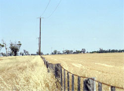
 Undulating rises east of Warracknabeal (note presence of gilgai microrelief) |
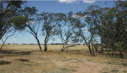
0.77% of CMA region Occurring in the north-east of the region, the Brim undulating rises represent a transitional soil-landform unit that graduates from Wimmera clay plains to Mallee hummocky dunes and plains. Cracking clay soils (Vertosols) and calcareous gradational soils (Calcarosols) can be found on plains, while rises include sodic red, yellow and grey texture contrast soils (Sodosols). Rises that comprise a continuous landscape along the eastern margin of the Yarriambiack Creek are dominated by vegetation communities associated with clay plains of the Wimmera and Mallee dunefields including Ridged Plains Mallee and Plains Savannah, while other communities such as Riverine Chenopod Woodland are associated with the broader plain. Other vegetation communities present include Low Rises Woodland, Plains Woodland, Woorinen Mallee and Parilla Mallee. Land use is mainly dryland cropping with soil compaction including development of plough pans a significant soil degradation issue. | 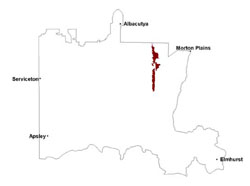 |
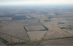
 Cropped plains and rises north of Warrachnabeal | 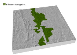 |
|
|
Component | 1 | 2 | 3 |
Proportion of soil-landform unit | 10% | 35% | 55% |
| CLIMATE Rainfall (mm) | Annual: 365 | ||
| Temperature (oC) | Minimum 9, Maximum 22 | ||
| Precipitation less than potential evapotranspiration | September–April | ||
| GEOLOGY Age and lithology | Neogene marine sand and silt (Parilla Sand); Quaternary aeolian dune sand, silt and clay; Quaternary fluvial silt, sand and minor gravel (Shepparton Formation) | ||
| Geomorphology | |||
| LANDUSE | Uncleared areas: nature conservation Cleared areas: dryland cropping; sheep grazing | ||
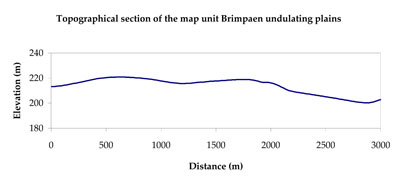
| TOPOGRAPHY Landscape | Undulating rises | ||
| Elevation range (m) | 91–143 | ||
| Local relief (m) | 5–6 | ||
| Drainage pattern | Dendritic | ||
| Drainage density (km/km2) | 0.6 | ||
| Landform | Rises | ||
| Landform element | Rise crest | Rise slope | Plain |
| Slope and range (%) | 3 (1-7) | 5 (3-10) | 3 (1-8) |
| Slope shape | Convex | Concave | Straight |
| NATIVE VEGETATION Ecological Vegetation Class | Ridged Plains Mallee (24.8%), Plains Savannah (20.0%), Riverine Chenopod Woodland (17.8%), Low Rises Woodland (15.6%), Plains Woodland (8.4%), Other (13.4%) | ||
| SOIL Parent material | Aeolian and marine sand, silt and clay | Aeolian and marine sand, silt and clay | Aeolian and fluvial sand, silt and minor gravel |
| Description (Corangamite Soil Group) | Sodic red texture contrast soils (27) | ||
| Soil type sites | |||
| Surface texture | Sandy loam | Loamy sand | Sandy clay loam |
| Permeability | Moderate | Moderate | Slow |
| Depth (m) | > 1.5 | > 2 | > 2 |
| LAND CHARACTERISTICS, POTENTIAL AND LIMITATIONS Critical land features, processes, forms | Hardsetting to loose surfaces susceptible to sheet and rill erosion along with wind erosion. Dispersive and deep subsoils susceptible to gully erosion where exposed. Soils are prone to compaction at critical moisture contents. | Wind erosion along with sheet and rill erosion occur as soils with little organicmatter. Subsoils are dispersive and susceptible to gully erosion on steeper slopes. Soils compact at critical moisture contents. | Soils can be subject to inundation and waterlogging especially on flats. Surfaces are slightly vulnerable to sheet erosion and wind erosion. Soils may be susceptible to compaction. |
© State of Victoria (Agriculture Victoria) 1996 - .

This work, Victorian Resources Online, is licensed under a Creative Commons Attribution 4.0 licence. You are free to re-use the work under that licence, on the condition that you credit the State of Victoria (Agriculture Victoria) as author, indicate if changes were made and comply with the other licence terms.
The licence does not apply to ‘branding’ or some ‘images or photographs’ that may be owned by third parties. We ask you to seek prior approval to use images using the VRO feedback form. Access to higher quality images can also be provided on request.
This page was last updated on .