
Soil/Landform Unit - Barton lava plains
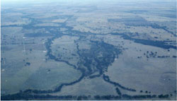
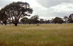 Gently undualting basalt plains near Barton |
0.09% of CMA region Lava plains west of Moyston at Barton represent the northern extent of the basalt plains in the Wimmera region that occur throughout Western Victoria. Occurring on the southern boundary of the CMA region, the plains are noted for gently undulating plains with infrequent stony rise outcrop across this landscape. Known as crab-hole country by locals (originally had yabbies across the plains prior to shallow drainage that removed vast quantities of surface water), soils are heavy and sodic brown, yellow and grey texture contrast soils with cracking clay soils scattered throughout. Heavy subsoils are susceptible to waterlogging and very hard when dry with acidification a concern where intensive dryland cropping occurs. On the western boundary, surficial deposits of aeolian sand occur especially where stony rises were once exposed. Vegetation communities found include Damp Sands Herb-rich Woodland, Plains Grassy Woodland, Sand Forest and Riparian Scrub. |  |
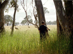 Emus on grazed plains near Nekeeya Creek | 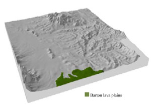 |
|  Native grasses on the basalt plains |
Component | 1 | 2 | 3 |
Proportion of soil-landform unit | 10% | 15% | 80% |
| CLIMATE Rainfall (mm) | Annual: 620 | ||
| Temperature (oC) | Minimum 8, Maximum 19 | ||
| Precipitation less than potential evapotranspiration | October–April | ||
| GEOLOGY Age and lithology | Neogene alkaline basalts, minor scoria and ash (Newer Volcanic Group); Quaternary fluvial gravel, sand and silt; Quaternary aeolian dune sand | ||
| Geomorphology | |||
| LANDUSE | Uncleared areas: nature conservation Cleared areas: sheep and beef cattle grazing; dryland cropping | ||
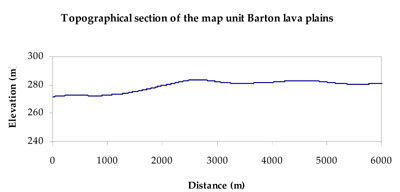
| TOPOGRAPHY Landscape | Undulating lava plain | ||
| Elevation range (m) | 247–310 | ||
| Local relief (m) | 10 | ||
| Drainage pattern | Deranged | ||
| Drainage density (km/km2) | 0.4 | ||
| Landform | Lava plains | ||
| Landform element | Drainage depression and swamp | Stony rise slope | Gently undulating lava plain |
| Slope and range (%) | 1 (1-3) | 5 (3-10) | 3 (1-8) |
| Slope shape | Concave | Convex | Linear |
| NATIVE VEGETATION Ecological Vegetation Class | Plains Grassy Woodland (46.4%), Sand Forest (32.1%), Damp Sands Herb-rich Woodland (10.7%), Other (7.1%) | ||
| SOIL Parent material | In situ basalt | In situ basalt | In situ basalt |
| Description (Corangamite Soil Group) | Cracking clay soils (8) | Sodic brown, yellow and grey texture contrast soils (9) | |
| Soil type sites | GRAMP269 | GRAMP269, ALRA69 | |
| Surface texture | Heavy clay | Clay loam - light clay | Clay loam |
| Permeability | Slow | Slow | Slow |
| Depth (m) | 2 | 0.5 | 1.2 |
| LAND CHARACTERISTICS, POTENTIAL AND LIMITATIONS Critical land features, processes, forms | Cracking clay soil susceptible to waterlogging and inundation. Sodic subsoils dispersive if disturbed. Upper soil susceptible to long-term compaction at critical moisture contents. | Heavy subsoil swells when wet and very hard when dry. Upper soil susceptible to long-term compaction at critical moisture contents. Slight susceptibility of upper soil to acidification. | Heavy subsoil swells when wet, susceptible to waterlogging and very hard when dry. Sodic subsoils could disperse if disturbed. Upper soil susceptible to long-term compaction at critical moisture contents. Slight susceptibility of upper soil to acidification. |
© State of Victoria (Agriculture Victoria) 1996 - .

This work, Victorian Resources Online, is licensed under a Creative Commons Attribution 4.0 licence. You are free to re-use the work under that licence, on the condition that you credit the State of Victoria (Agriculture Victoria) as author, indicate if changes were made and comply with the other licence terms.
The licence does not apply to ‘branding’ or some ‘images or photographs’ that may be owned by third parties. We ask you to seek prior approval to use images using the VRO feedback form. Access to higher quality images can also be provided on request.
This page was last updated on .