
Land Use 1996 - 2005
In 1994 an Australian Land Use Mapping (ALUM) standard was developed for the Murray Darling Basin Commission (MDBC) (Baxter and Russell 1994). In 1996 a collaborative national land use mapping initiative called the Australian Collaborative Land Use Mapping Program (ACLUMP) was established. This initiative further refined the ALUM classification (Bureau of Rural Sciences 2006) and this was used when the DPI in Victoria began a state-wide mapping program in Gipplsand in 1996 that was finished in the lower Goulburn in 2005. Below shows the 6 major ALUM categories for Victoria.
| For further information on the ALUM classification method, please refer to the Australian Bureau of Agricultural and Resource Economics and Sciences (ABARES) Land Use and Management Information for Australia (external link). The map to the below shows the temporal extent of the various land use layers used to create the Victorian Land use map between 1996 and 2005. | 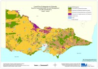 Victorian land use |
This land use map was created from data collected between 1996 (South West, North Central) and 2005 (North East, Lower Goulburn). The land use classification system used in Victoria at this time was the Australian Land Use and Management (ALUM) classification. The classification consists of six main categories, each further divided into two extra tiers. The six primary categories are:
| 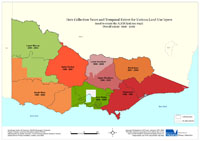 Map showing temporal extent of land use layers |
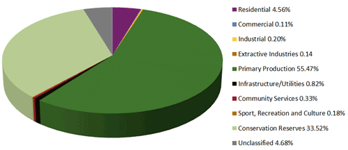
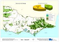
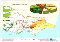
| Land Use Information 1996 - 2005 Approximately 39% of Victoria’s land was public land; the remaining 61% was private or freehold. Of all the land uses in the state, dryland agriculture and horticulture comprised approximately 53%, whereas irrigated agriculture and horticulture was less than 4%. More detailed overview land use mapping (2001-02) is available for the Corangamite and Port Phillip and Westernport regions. | 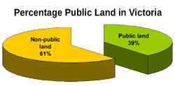 |
Private Forestry and Other Freehold
Private Forestry plantations are a small, but growing land use in Victoria. Many areas in the south and north east are suited to commercial forestry and significant increases in the areas planted are expected over the next ten years.
Other freehold land mainly covers the metropolitan areas. The centres of Melbourne, Geelong, Ballarat and Bendigo can be easily seen on the map.
| National and State Parks This map shows the location of State and National Parks in Victoria (as at January 2006). Parks Victoria manages Victoria's world class network of national, state, regional and metropolitan parks, other conservation reserves, many significant cultural assets, and Melbourne's bays and major waterways. The Parks Victoria Parkweb website (external link) provides information about each of Victoria's National and State Parks. | 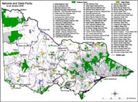 National and State Parks |
Forestry, Public Plantation and Other Public Land
Public forestry plantations are a significant land use in localised areas in the south west, Strzelecki Ranges and in the north east. Other public land areas have a range of land uses including forestry, recreation protected water supply catchments and conservation.
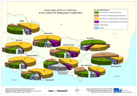
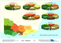
Statistical Maps and Diagrams
The following maps and diagrams provide some statistical information, with a focus on Victoria and the various Catchment Management Authorities (CMA) based on the 1996 – 2005 data.
© State of Victoria (Agriculture Victoria) 1996 - 2025.

This work, Victorian Resources Online, is licensed under a Creative Commons Attribution 4.0 licence. You are free to re-use the work under that licence, on the condition that you credit the State of Victoria (Agriculture Victoria) as author, indicate if changes were made and comply with the other licence terms.
The licence does not apply to ‘branding’ or some ‘images or photographs’ that may be owned by third parties. We ask you to seek prior approval to use images using the VRO feedback form. Access to higher quality images can also be provided on request.
This page was last updated on 23/03/2020.