
Satellite Image of Victoria
The satellite image shows Victoria's land mass in 1993, using Landsat 5.
The image is a mosaic of seventeen Landsat satellite Thematic Mapper images taken from 750 kilometres above the earth. The Thematic Mapper records wavelengths of reflected and radiated light from the earth's surface, in seven different bands. These bands range from the visible blue through to the mid infra red portion of the light spectrum.
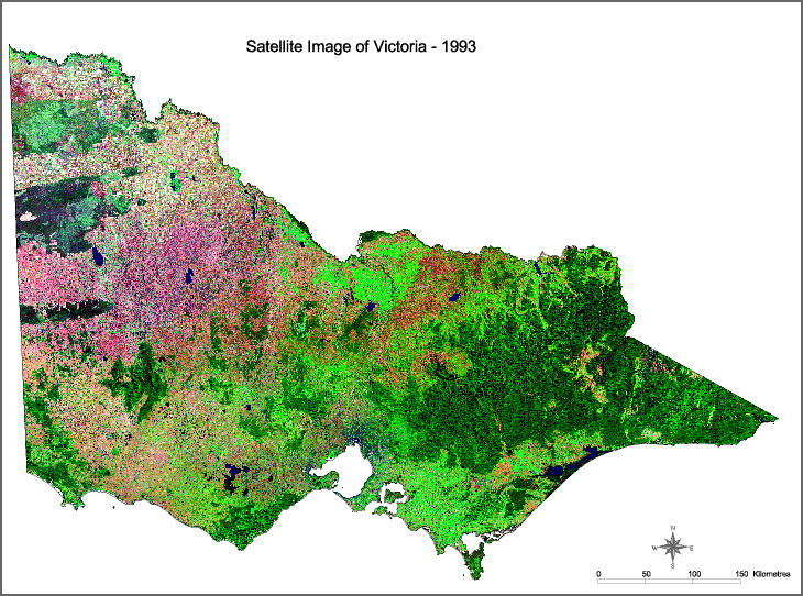
This image shows the visible blue, the near infra red and the mid infra red bands. These are shown in the blue, green and red colour guns, respectively. Although the image is a false colour image, this combination of bands and colours provides an approximation of true colour.
The near infra red, displayed in the green colour gun, highlights chlorophyll in vegetation. Forest and other vegetation cover appears as dark green and slightly brown, while irrigated pasture and crops appear as light green.
The mid infra red, displayed in the red colour gun, also highlights vegetation as well as ground and soil reflectance. Hence, dry pastures and crops are characterised by the various shades containing red such as the browns, oranges and pinks.
The visible blue band, displayed in the blue colour gun, highlights water bodies and can provide an indication of their relative depth. Deep bodies of water appear almost black, while shallow bodies are a much lighter blue.
The dates of the seventeen images range from January 1993 to February 1993. All have been recorded in summer months when the maximum differences between forest and other land covers can best be discriminated.
Some areas of particular interest in this image include:
- the distinctive broad acre cropping patterns in the north west of the state
- the natural fire scar patterns observed in the Wyperfeld National Park and the Big Desert Wilderness Park in the north west
- the geological structures in the Grampians National Park in the south west
- the channels and waterways of the Corner Inlet Marine and Coastal Park, in south Gippsland
- irrigated regions in northern part of the state
The satellite imagery was captured by the Australian Centre for Remote Sensing (ACRES). All image processing, enhancement and mosaicing was undertaken by Natural Resource Systems (NRS).
© State of Victoria (Agriculture Victoria) 1996 - .

This work, Victorian Resources Online, is licensed under a Creative Commons Attribution 4.0 licence. You are free to re-use the work under that licence, on the condition that you credit the State of Victoria (Agriculture Victoria) as author, indicate if changes were made and comply with the other licence terms.
The licence does not apply to ‘branding’ or some ‘images or photographs’ that may be owned by third parties. We ask you to seek prior approval to use images using the VRO feedback form. Access to higher quality images can also be provided on request.
This page was last updated on .