
Jamieson (Jn)
 | Area: 109 sq. km (0.8%) During late Tertiary and Pleistocene times major rejuvenation of drainage and hillslopes occurred through most of the East Victorian Uplands. However, some north-south trending interfluves have not yet been dissected by the modern drainage network and prior landscape residuals, probably pre-dating the Older Volcanics, are preserved. Those mapped in Jamieson land system are relatively undissected plateaux, mainly on Ordovician sediments, at high elevations but below the subalpine tract. Residuals within the subalpine tract are in Bennison land system. More dissected residuals are in Bulltown Spur land system and those with denser, more-humid forests in Wellington land system. The dominant gentle slopes reduce natural erosion rates and relatively deep soils have resulted from the weathering of moderately-resistant parent rocks under high rainfall and a cool climate. The soils tend to have a well-developed, fine structure and are moderately to strongly acidic. The dominant vegetation is open forest II or III, often shrubby or layered, with ferny open forest I or sedgey woodland I on valley floors. | 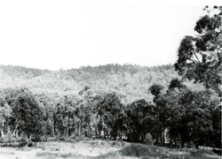 Steeper, timbered slopes typical of the peripheral sloping areas |
Rainfall, mean (mm) Temperature Seasonal growth limitations, mean (°C) | Annual 800 - 1400; lowest January or February (50 - 90), highest August or September (120 - 180) Annual 8 - 12; lowest July (3 - 7), highest February (16 - 20) Temperature <10°C (av.): April - October Rainfall < potential evapotranspiration: December - February; occasional winter snow |
Age, lithology | Mainly Ordovician mudstones and sandstones |
Landscape Elevation range (m) Relative relief (m) Drainage pattern Drainage density (km/km2) | Relatively undissected prior landscape remnants, mainly pre-dating the Older Volcanics 400 – 1360 40 – 320 Dendritic 1.1 |
| Uncleared: hardwood forestry (variable timber); bush grazing of cattle; apiculture |
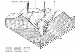 | 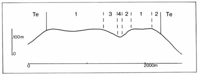 |
Percentage of land system Diagnostic features | 1 70 Undulating and sloping plateaux remnants with less humid forest then in component 3 | 2 15 Peripheral steeper slopes with less humid forest than in component 3 | 3 10 Protected slopes with vigorous humid forest | 4 5 Valley flats |
Slope %, typical and (range) Slope shape | 8-15 (0-20) Straight or slightly convex | 25-30 (20-40) Convex | 15-25 (10-40) Straight | <5 (0-10) Concave, straight |
| ||||
| Mudstone, sandstone; some metamorphic rock | Colluvium and locally derived alluvium | ||
| Black to dark brown loam to clay loam grading into reddish brown or brown loam to light clay, acid and usually finely structured throughout; sometimes shallow and stony, particularly in component 2. | Limited observations – as in components 1 and 2 but thicker dark coloured topsoil; shallow soil less common | Dark greyish brown to dark grey sandy loam to sandy clay loam; mottled subsoil | |
| Red and Brown Earths; less commonly, Lithosols Gn2.11, Gn2.21, Gn4.14, Um6.13, Um6.24, Um5.52 | Krasnozems Gn4.11 | Alluvial Soils; possibly Humic Gleys Um6.23, Gn4.51 | |
| Loam to sandy clay loam | Loam to sandy clay loam | Sandy loam to sandy clay loam | |
| Friable to firm when moist | Friable to firm when moist | Very friable when moist | Variable |
| 1.2-1.8 | <0.8 | >1.2 | >2.0 |
| Low to moderate | Low to moderate | Low to moderate | |
| Moderate | Moderate | High | |
| Rapid | Rapid | Rapid | |
| Good | Good | Poor to somewhat poor | |
| Usually 0 | 0 | 0 | |
| - | 36 | - | |
Structure of vegetation and characteristic species of dominant stratum (+ Predominant species) | Open forest II, III, often shrubby or layered: E. pauciflora and E. rubida, with or without E. dives, at highest elevations; elsewhere, pure or mixed stands with species including E. dives, E. rubida, E. obliqua, E. baxteri | Limited observations – probably layered open forest III: Higher elevations – E. delegatensis+; with or without E. rubida+ Lower elevations – E. obliqua+, with or without E. regnans | Sedgey woodland I: E. camphora, Carex appressa Occasional fern open forest I: E. neglecta | |
Disturbance | Affected process and trend | Primary resultant deterioration | Casual activities | Primary off-site process | ||
Form | Susceptibility of components | Incidence with components | ||||
| Reduced transpiration, resulting in increased deep percolation | Nutrient loss | Not determined | Not determined | Removal of trees | Increased movement of water to groundwater; increased base-flow of streams |
| Increased overland flow and soil detachment | Sheet and rill erosion | 1,3; low 2; moderate | Not determined | Clearing, logging, burning, road building activities, trafficking by stock and vehicles. | Increased flash flows and sediment load. and other earth-moving |
| Increased compaction With Reduced infiltration | Structure decline Sheet and rill erosion | 1,2; low 3,4; moderate – high 1,3; low 2; moderate | Not determined Not determined | Increased trafficking, overgrazing, export of organic matter As for sheet and rill erosion above | - Increased flash flows |
| Increased soil break-up | Gully erosion | 1; low 2,3; moderate | Not determined | As for sheet and rill erosion above | Increased sediment load. |
| Comments: No observations of soil deterioration | ||||||
© State of Victoria (Agriculture Victoria) 1996 - .

This work, Victorian Resources Online, is licensed under a Creative Commons Attribution 4.0 licence. You are free to re-use the work under that licence, on the condition that you credit the State of Victoria (Agriculture Victoria) as author, indicate if changes were made and comply with the other licence terms.
The licence does not apply to ‘branding’ or some ‘images or photographs’ that may be owned by third parties. We ask you to seek prior approval to use images using the VRO feedback form. Access to higher quality images can also be provided on request.
This page was last updated on .