
Wellington (Wn)
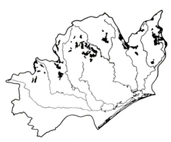 | Area: 418 sq. km (2.0%) Wellington land system occurs below the subalpine tract in the East Victorian Uplands, on partially-dissected, prior-landscape remnants that probably predate the Older Volcanics. These remnants have not yet been affected by erosion associated with entrenchment of the modern drainage network. The topography is hilly to undulating and plateau tops are almost accordant. Lithology varies but acid volcanics, metamorphic rocks and slightly-weathered, sedimentary rocks are well represented. Jamieson land system is also mapped on hilly to undulating, prior land surfaces that probably predate the Older Volcanics and which are below the subalpine tract. Plateaux in Wellington land system differ from those in Jamieson, having greater relief and being more humid and densely forested, particularly in the west. The soils have developed on moderately steep slopes and under high rainfall on a variety of parent rocks. There is a predominance of gradational, leached, acidic soils of intermediate texture, moderately to strongly structured throughout. Where slopes are steeper, or the rocks are more resistant to weathering, the soils tend to be shallow and uniform in texture. Most of the area is covered by open forest II or III, often shrubby or layered, with less vigorous stands on shallow, rocky soils. | 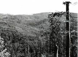 View across to the gentle to moderate slopes of the plateau suirface |
| CLIMATE Rainfall, mean (mm) Temperature, mean (°C) Seasonal growth limitations |
Annual 900 - 1600; lowest January or February (50 - 90), highest August or September (120 - 180) Annual 8 - 12; lowest July (3 - 7), highest February (16 - 20) Temperature <10°C (av.): April - October Rainfall < potential evapotranspiration: February; frequent winter snow |
GEOLOGY
|
|
| PHYSIOGRAPHY Landscape Elevation range (m) Relative relief (m) Drainage pattern Drainage density (km/km2) |
Partially dissected hilly to undulating prior landscape residuals 560 - 1460 100 - 500 Dendritic 0.9 |
| PRESENT LAND USE |
|
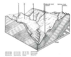 | 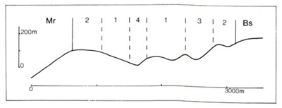 |
| LAND COMPONENT Percentage of land system Diagnostic features | 1 40 Moderate slopes with deeper soils; sedimentary or igneous rocks | 2 40 Gentle slopes with deeper soils; sedimentary or igneous rocks | 3 15 Slopes of any gradient with shallow rocky soils; mainly Ordovician sediments | 4 5 Drainage depressions, often with minor swamps |
| PHYSIOGRAPHY Slope %, typical and (range) Slope shape | 20 - 30, (15 - 50) Straight to concave | 5 - 10, (2 - 15) Mainly concave | 20 - 30, (15 - 50) Straight to convex | Variable, (10 - 40) Straight, some concave |
| SOIL | ||||
| Parent material | Variable; mostly rhyolite, rhyodacite, and siltstone; minor granodiorite | Sandstone, mudstone and shale | Colluvium and alluvium | |
| Description | Mainly dark brown sandy clay loam grading into yellowish brown to reddish brown sandy clay loam to light clay with fine structure, commonly stony; topsoil often deep | Mainly shallow brown stony sandy loam to sandy clay loam | Limited observations — probably dark, undifferentiated with much organic matter and variable texture | |
| Classification | Red and Brown Earths; Krasnozems Gn4.11, Gn4.31, Gn3.11, Gn2.11, Gn4.81, Um4.21, Um6.11, Um6.12, Um6.23, Um7.11 | Lithosols, Brown Earths Um-, Um6.23, Uc1.44 | Humic Gleys Uc1.24 | |
| Surface texture | Sandy clay loam, sometimes loam or clay loam | Sandy loam to sandy clay loam | - | |
| Surface consistence | Soft when dry, friable when moist | Friable when moist | - | |
| Depth (m) | Generally 1.0 - 2.0 | <0.8 | - | |
| Nutrient status | Low to moderate | Low | Probably low | |
| Available soil water capacity | Moderate | Low | Probably moderate | |
| Perviousness to water | Rapid | Slow to moderate | Probably rapid | |
| Drainage | Good | Good | Very poor to poor on alluvium; better on colluvium | |
| Exposed stone (%) | Often 0, but 5 - 30 not uncommon | Probably >10 | Probably 0 | |
| Sampled profile number | 32 | - | - | - |
| NATIVE VEGETATION Structure of vegetation and characteristic species of dominant stratum (+ Predominant species) | Mostly open forest II, III, often shrubby or layered: Mixed or pure stands with composition dependent on elevation and aspect; Higher elevations — E. delegatensis, E. dives, E. pauciflora, E. radiata, E. rubida Lower elevations — E. cypellocarpa, E. dives, E. obliqua, E. regnans, | Open forest I or II: species including — and occasionally E. nitens, E. viminalis | Limited observations — probably open forest I of Leptospermum grandifolium | |
Disturbance | Affected process and trend | Primary resultant deterioration | Causal activities | Primary off-site process | ||
Form | Susceptibility of components | Incidence within components | ||||
| Alteration of vegetation: — reduction in leaf area, rooting depth and/or perenniality — reduction in density of tree roots | Reduced transpiration, resulting in: a) increased deep percolation b) increased regolith wetness Decreased root-binding | Not determined Soil creep Soil creep | Not determined 1; moderate 1; moderate | Not determined Uncommon: observed occasionally on steep slopes as a natural process Uncommon: observed occasionally on steep slopes as a natural process | Removal of trees Usually after the removal of trees from steeper land Accelerated by major disturbance to the native vegetation | Increased movement of water to groundwater; increased base-flow of streams Increased sediment load Increased sediment load |
| Increased exposure of surface soil | Increased overland flow and soil detachment | Sheet and rill erosion | 1,3; moderate 2; low - moderate | Uncommon: locally severe | Clearing, logging, burning, overgrazing, road building and other earth-moving activities, trafficking by stock. | Increased flash flows and sediment load. |
| Increased physical pressure on soil | Increased compaction With Reduced infiltration | Structure decline Sheet and rill erosion | 1,2; moderate 3; low 4; moderate – high 1,3; moderate 2; low - moderate | Uncommon Uncommon: locally severe | Increased trafficking, export of organic matter As for sheet and rill erosion above | - Increased flash flows |
| Increased soil disruption | Increased soil break-up | Gully erosion | 1,2,3,4; moderate | Uncommon | As for sheet and rill erosion above | Increased sediment load. |
| Comments: - | ||||||
© State of Victoria (Agriculture Victoria) 1996 - .

This work, Victorian Resources Online, is licensed under a Creative Commons Attribution 4.0 licence. You are free to re-use the work under that licence, on the condition that you credit the State of Victoria (Agriculture Victoria) as author, indicate if changes were made and comply with the other licence terms.
The licence does not apply to ‘branding’ or some ‘images or photographs’ that may be owned by third parties. We ask you to seek prior approval to use images using the VRO feedback form. Access to higher quality images can also be provided on request.
This page was last updated on .