
Bulltown Spur (Bp)
 | Area: 132 sq. km (0.7%) After deposition of the Older Volcanics in the valleys, erosion of the surrounding, softer sediments led to an inversion of the relief and the resistant basalts formed ridge cappings. This new land surface probably formed during the Pliocene. Downcutting by rivers subsequent to the Plio-Pleistocene Kosciusko Uplift has incised and removed most of the Pliocene surface but some relics are perched above the recently formed valleys. Most are dissected remnants of a sloping erosional surface and are mapped in Bulltown Spur land system. Also included are parts of the "pre Older Volcanic" land surface that are too steep and dissected to be included in Wellington and Jamieson land systems. Soil development shows certain parallels with that in Wellington and Jamieson land systems. Leached, reddish brown soils with little textural change have formed by the action of a cool, humid climate on moderately-resistant parent rock. In Bulltown Spur land system the slopes are steeper and have more natural erosion, thus the soils are usually shallow and stony. The vegetation is mainly open forest II or III, with woodland I on steeper. rocky slopes at lower elevations. On moderate slopes, understoreys are shrubby or ferny: on steeper rocky sites understoreys are sparse. | 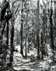 A gentle crest with Eucalyptus obliqua (messmate stringybark) forest. A gentle crest with Eucalyptus obliqua (messmate stringybark) forest. |
| CLIMATE Rainfall, mean (mm) Temperature, mean (°C) Seasonal growth limitations |
Annual 800 - 1400; lowest January or February (40 - 80), highest October (100 - I50) Annual 8 - 12; lowest July (3 - 7). highest February (16 - 20) Temperature <10°C (av.): April - October Rainfall < potential evapotranspiration: December - February; occasional winter snow |
| GEOLOGY Age, lithology |
Mainly Ordovician sandstones, siltstones and shales but also including Carboniferous sandstones, siltstones, conglomerates and Wellington Rhyolites |
| PHYSIOGRAPHY Landscape Elevation range (m) Relative relief (m) Drainage pattern Drainage density (km/km2) |
Hilly to sloping prior landscape remnants 400 - 1460 80 - 560 Dendritic 1.3 |
| PRESENT LAND USE |
|
 |  |
| LAND COMPONENT Percentage of land system Diagnostic features | 1 100 Complex of slopes and crests of varying steepness and degree of rockiness. This variability combined with variation in aspect and elevation produces a mosaic of vegetation types differing in structure and composition. No components distinguished |
| PHYSIOGRAPHIC Slope %, typical and (range) Slope shape | 30 - 50, (10 - 70) Straight |
| SOIL | |
| Parent material | Sandstone. siltstone and shale; some rhyolite |
| Description | Mostly shallow and stony with dark brown crumb-structured sandy loam to sandy clay loam topsoil grading into reddish brown structureless clay loam or light clay: moderately to strongly acidic |
| Classification | Red Earths, Lithosols/Red Earths Um 5.51. Um 5.52, Um 7.11, Gn 2.11 |
| Surface texture | Sandy loam to sandy clay loam |
| Surface consistence | Soft when dry. very friable when moist |
| Depth (m) | <0.8 with deeper pockets to 1.5 |
| Nutrient status | Low |
| Available soil water capacity | Moderate |
| Perviousness to water | Rapid |
| Drainage | Good |
| Exposed stone (%) | <5 |
| Sampled profile number | 29 |
| NATIVE VEGETATION Structure of vegetation and characteristic species of dominant stratum (+ Predominant species) | Structure variable, observed to range from woodland Ito open forest II or III with grassy. ferny or shrubby understories. Usually mixed stands with variable composition; species include: Higher elevations — E. dives, E. delegatensis. E. pauciflora. E. rubida Lower elevations — E. cypellocarpa, E. dives, E. goniocalyx, E. macrorhyncha, E. mannifera, E. obliqua. E. sieberi |
Disturbance | Affected process and trend | Primary resultant deterioration | Casual activities | Primary off-site process | ||
Form | Susceptibility of components | Incidence with components | ||||
— reduction in leaf area, rooting depth and/or perenniality | Reduced transpiration, resulting in increased deep percolation and leaching | Nutrient loss | Not determined | Not determined | Removal of trees | Increased movement of water to groundwater: increased base-flow of streams |
| Increased overland flow and soil detachment | Sheet and rill erosion | 1; moderate - high | Not determined | Clearing, logging, burning, road building and other earth-moving activities. | Increased flash flows and sediment load |
| Increased compaction With reduced infiltration | Structure decline Sheet and rill erosion | 1; moderate 1; moderate - high | Not determined Not determined | Loss of organic matter, increased soil disturbance. As for sheet and rill erosion above | - Increased flash flows |
| Increased soil break-up | Gully erosion | l; moderate - high | Not determined | As for sheet and rill erosion above | Increased sediment load |
| Comments: No observations of deterioration | ||||||
© State of Victoria (Agriculture Victoria) 1996 - .

This work, Victorian Resources Online, is licensed under a Creative Commons Attribution 4.0 licence. You are free to re-use the work under that licence, on the condition that you credit the State of Victoria (Agriculture Victoria) as author, indicate if changes were made and comply with the other licence terms.
The licence does not apply to ‘branding’ or some ‘images or photographs’ that may be owned by third parties. We ask you to seek prior approval to use images using the VRO feedback form. Access to higher quality images can also be provided on request.
This page was last updated on .