
Bennison (Bs)
 | Area: 296 sq. km (1.5%) Bennison land system is mapped on plateaux occurring in subalpine areas and occasionally extending into the upper montane tract. The plateaux are perched above the major areas of ridge-and-ravine topography. Lithology varies and includes sedimentary rocks, their metamorphic equivalents and intrusive igneous rocks. High-elevation plateaux on basalt are mapped in Nunniong land system. The slopes of the plateaux are low although the local terrain is hilly to undulating. A number of lakes, most of which have been drained through natural causes, hogs and drainage depressions are mapped in Moroka land system. Where these drainage areas are too small to be mapped at 1:100,000, they have been included as a component of Bennison land system. | 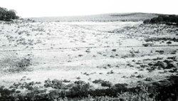 Plateau north of Mount Tamboritha with undulating terrain characteristic of Bennison land system. |
| A cold climate and high rainfall have combined to produce soils that are friable and acidic, with a high concentration of organic matter in the topsoil and little textural change down the profile. The most common parent rock types are low in plant nutrients and this is reflected in the soils. The more protected parts of this land system tend to have deeper, more humus-enriched soils, with stronger structural development and a higher degree of profile differentiation. The vegetation is mainly shrubby woodland I or II. with shrubby or grassy open forest II. III or IV on more protected sites. Tussock grassland occurs in wetter areas or on the flanks of ancient lakes. Heaths, sedges and mosses grow in hogs. | ||
| CLIMATE Rainfall, mean (mm) Temperature, mean (°C) Seasonal growth limitations |
Annual 900 - 1600: lowest January or February, highest August or September (150 - 180) Annual 4 - 8; lowest July (-2 - 0), highest February (II - 13) Temperature <10°C (av.): April - October Rainfall < potential evapotranspiration: February; frequent winter snow |
| GEOLOGY Age, lithology |
Palaeozoic shales, sandstones and related metamorphic rocks; minor areas of rhyolites and rhyodacites and granites and granodiorites. Basalt excluded |
| PHYSIOGRAPHY Landscape Elevation range (m) Relative relief (m) Drainage pattern Drainage density (km/km2) |
Hilly to undulating terrain 940 - 1600 40 - 240 Dendritic 1.2 |
| PRESENT LAND USE |
|
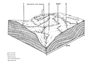 | 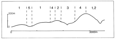 |
| LAND COMPONENT Percentage of land system Diagnostic features | 1 40 Slopes with woodlands | 2 35 Slopes with forests (non E. delegatensis species) | 3 10 Non-timbered slopes adjacent to drainage depressions may be flanks of prior lakes. | 4 10 Slopes with forests of E. delegatensis | 5 5 Drainage depressions and valley flats, often boggy, with terraces |
| PHYSIOGRAPHY Slope %, typical and (range) Slope shape | 5 - 10, (0 - 30) Straight to concave | 10 - 15, (0 - 30) Concave | Variable, (0 - 10) Convex | 10 – 20, (0 - 40) Concave | <5, (0 - 10) Straight |
| SOIL | |||||
| Parent material | Shale, sandstone: some related metamorphic rock; minor rhyolite and rhyodacite | ||||
| Description | Very dark loam to sandy clay loam merging into reddish brown or yellowish brown loam to sandy clay loam, often stony throughout | Dark brown to black sandy clay loam merging into dark greyish brown sandy clay loam, often shallow | Very dark loam to clay loam merging into brown loam; may be stony. Soils deeper than in components 1 and 2 | Colluvium and alluvium Variable: generally shallow organic loams over grey or yellowish brown mineral soil | |
| Classification | Mainly Red Earths; Brown Earths and some Lithosols Um5.52, Um5.51, Um6.12, Um6.24, Um7.11. Um4.31, Uc5.21. some Gn- and Um 1-. | Brown Earths Um5.21. Um 1.43 | Brown Earths; Alpine Humus Um6.12. Um7.11 | Humic Gleys, Alluvial Soils: shallow Peat in places 0, Uc1.44. Um5,52 | |
| Surface texture | Loam to sandy clay loam | Sandy clay loam | Loam to clay loam | Variable | |
| Surface consistence | Soft to slightly hard | Slightly hard | Soft to slightly hard | - | |
| Depth (m) | 0.4-1.5 | 0.3-0.8 | 1.0-2.0 | 0.3- 1.0 | |
| Nutrient status | Low | Low | Low | Low | |
| Available soil water capacity | Moderate | Moderate | Moderate to high | High | |
| Perviousness to water | Moderate to rapid | Moderate to rapid | Rapid | Rapid | |
| Drainage | Good | Somewhat poor to good | Good | Very poor to somewhat poor | |
| Exposed stone (%) | Variable: 0 - 50 | 0 - 10 | Variable: 0 - 50 | 0 - 10 | |
| Sampled profile number | - | - | - | - | |
| NATIVE VEGETATION Structure of vegetation and characteristic species of dominant stratum (+ Predominant species) | Shrubby woodland I, II: E pauciflora+ and/or E. rubida+ | Shrubby or grassy open forest II: E. pauciflora+ with or without E. dives: E. dives+; E. rubida+ | Tussock grassland: Poa spp.+, Restio spp. Heath: Hakea microcarpa+. Helichrysum hookeri+ | Shrubby or grassy open forest III. IV: E. delegatensis+, E. rubida+ | Better drained sites either with shrubby open woodland I. lI of pure or mixed stands of E. pauciflora, E. rubidia, E. stellulata or with tussock grassland of Poa spp. Bogs with Baeckea gunniana+, Calorophus lateriflorus and Sphagnum cristatum+ |
Disturbance | Affected process and trend | Primary resultant deterioration | Casual activities | Primary off-site process | ||
Form | Susceptibility of components | Incidence with components | ||||
— reduction in leaf area, rooting depth and/or perenniality | Reduced transpiration. resulting in: a) increased deep percolation b) decreased fog drip c) increased rate of snow melt d) increased depth of soil freezing | Nutrient loss - - Solifluction | Not determined - - 1; low | Not determined - - Uncommon | Removal of trees | Increased movement of water to groundwater; increased base-flow of streams Decreased stream base flow Increased spring and decreased summer stream flow - |
| Increased overland flow and soil detachment Increased frost heave and soil detachment | Sheet and rill erosion Wind and sheet erosion | 1,2,3.4; low 1.2; low | Uncommon: locally severe Uncommon | Clearing, logging, road building and other earth-moving activities, trafficking by stock and vehicles. Clearing, logging, road building and other earth-moving activities, trafficking by stock and vehicles. | Increased flash flows and sediment load. Increased sediment load |
| Increased compaction With reduced infiltration | Structure decline Sheet and rill erosion | 1; low - moderate 2.3.4: moderate - high 5; high 1.2.3.4: low | Uncommon; locally severe particularly in cattle camp areas Uncommon: locally severe | Increased trafficking by stock, humans and vehicles As for sheet and rill erosion above | Increased spring and decreased summer stream flow Increased flash flows and sediment load |
| Increased soil break-up | Gully erosion Streambank erosion | 1.2.4.5; moderate 3; low 5: moderate | Uncommon Uncommon; locally severe | As for sheet and rill erosion Trafficking by stock and humans, increased stream flow | Increased sediment load. Increased turbidity of streams |
| Comments: Regeneration of vegetative cover on higher-elevation. More exposed sites is slow and difficult because of the unfavourable climate. | ||||||
© State of Victoria (Agriculture Victoria) 1996 - .

This work, Victorian Resources Online, is licensed under a Creative Commons Attribution 4.0 licence. You are free to re-use the work under that licence, on the condition that you credit the State of Victoria (Agriculture Victoria) as author, indicate if changes were made and comply with the other licence terms.
The licence does not apply to ‘branding’ or some ‘images or photographs’ that may be owned by third parties. We ask you to seek prior approval to use images using the VRO feedback form. Access to higher quality images can also be provided on request.
This page was last updated on .