
Glenmaggie (Ge)
 | Area: 174 sq. km (0.9%) This land system is mapped on hilly terrain with Carboniferous sediments and occurs close to the lower margin of the East Victorian Uplands and along some of the major river valleys. The ridge-and-ravine topography has moderately long, steep slopes prone to soil creep and rock outcrop is common. Small alluvial terraces similar to those mapped in Walnut land system occur in the major drainage corridors, for example along the Avon River. Glenmaggie is similar to Avon and Turton land systems in that it occurs on similar lithology in the less-humid areas, but is intermediate in relief and degree of dissection. Turton land system has the greatest relief and dissection and Avon the least. Shallow, stony soils dominate because of high, natural erosion rates on the steep slopes, slow rates of soil formation on the siliceous, sedimentary parent rocks and moderate rainfall. The soils are acidic and tend to have little structural development except in the topsoils and those subsoils that are clayey. Open forest II dominates with some open forest III on protected hill slopes and in major drainage corridors. | 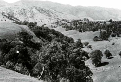 The lower relief and more gentle, cleared slopes of Glenmaggie land system contrast with the higher relief and steeper, forested slopes of Turton land system |
| CLIMATE Rainfall, mean (mm) Temperature, mean (°C) Seasonal growth limitations | Annual 600 - 900; lowest July (40 - 70), highest October (60 - 90) Annual 8 - 12; lowest July (3 - 7), highest February (16 - 20) Temperature <10°C (av.): May - September Rainfall < potential evapotranspiration: November – March |
| GEOLOGY Age, lithology | Carboniferous siltstones, minor sandstones and conglomerates, often red (Snowy Plains Formation) |
| PHYSIOGRAPHY Landscape Elevation range (m) Relative relief (m) Drainage pattern Drainage density (km/km2) | Hilly terrain with ridge-and-ravine topography 150 - 520 80 - 360 Dendritic 1.8 |
| PRESENT LAND USE | Mostly uncleared: hardwood forestry (mainly minor products); apiculture (limited); bush grazing of cattle Minor proportion cleared: grazing of beef cattle and sheep |
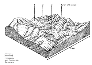 | 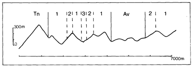 |
| LAND COMPONENT Percentage of land system Diagnostic features | 1 75 Exposed slopes, often with outcrops of sub-horizontal beds | 2 15 Protected slopes | 3 10 Discontinuous terraces of major drainage corridors |
| PHYSIOGRAPHY Slope %, typical and (range) Slope shape | 25 - 35, (20 - 60) Straight | 25 - 35, (20 - 60) Straight | <5, (0 - 10) Mostly straight |
| SOIL | |||
| Parent material | Siltstone, sandstone and conglomerate | Stony alluvium | |
| Description | Limited observations — mostly shallow and stony with very dark greyish brown sandy loam topsoil merging into yellowish brown or reddish brown sandy loam; topsoil sometimes resting on yellowish brown clay | Limited observations — little differentiated and stratified soils varying from sandy loam to clay loam, often stony | |
| Classification | Lithosols, Brown Podzolic Soils Uc1.41, Uc4.13, Dy2.41 | Alluvial Soils Um1.41 | |
| Surface texture | Mainly lighter textures, e.g. sandy loam | Variable | |
| Surface consistence | Slightly hard when dry, friable to firm when moist | Variable | |
| Depth (m) | Probably 0.5 - 0.8, but deeper in pockets | >2.0 | |
| Nutrient status | Low to moderate | Low to moderate | |
| Available soil water capacity | Moderate | Moderate | |
| Perviousness to water | Moderate | Moderate | |
| Drainage | Good | Mostly good | |
| Exposed stone (%) | Variable; <50 | <20 | |
| Sampled profile number | - | - | |
| NATIVE VEGETATION Structure of vegetation and characteristic species of dominant stratum (+ Predominant species) | Open forest II: Mixed forests with variable composition — including E. macrorhyncha+, E. polyanthemos+, E. consideniana, E. muellerana, E. sieberi | Open forest II, III: Mixed forests with variable composition — including E. cypellocarpa+, E. globoidea+, E. polyanthemos+, E. goniocalyx | Shrubby open forest II, III: E. melliodora+ and/or E. viminalis+ |
Disturbance | Affected process and trend | Primary resultant deterioration | Casual activities | Primary off-site process | ||
Form | Susceptibility of components | Incidence with components | ||||
— reduction in leaf area, rooting
|
resulting in: a) increased deep percolation b) increased regolith wetness Decreased root-binding |
Nutrient loss Soil creep Soil creep |
Not determined 1,2; high 1,2; high |
Not determined Common: on steep slopes Common: on steep slopes |
Removal of trees Accelerated by clearing of native vegetation Accelerated by clearing of native vegetation |
Increased movement of water to groundwater; increased base-flow of streams Increased sediment load Increased sediment load |
|
|
|
|
|
|
|
|
With reduced infiltration |
Sheet and rill erosion |
2; moderate 1,2; high |
Not determined |
As for sheet and rill erosion above |
Increased flash flows |
|
|
Streambank erosion |
3; high |
Common: locally severe in major drainage corridors |
As for sheet and rill erosion above |
Increased turbidity of streams |
| ||||||
© State of Victoria (Agriculture Victoria) 1996 - .

This work, Victorian Resources Online, is licensed under a Creative Commons Attribution 4.0 licence. You are free to re-use the work under that licence, on the condition that you credit the State of Victoria (Agriculture Victoria) as author, indicate if changes were made and comply with the other licence terms.
The licence does not apply to ‘branding’ or some ‘images or photographs’ that may be owned by third parties. We ask you to seek prior approval to use images using the VRO feedback form. Access to higher quality images can also be provided on request.
This page was last updated on .