
Avon (Av)
 | Area: 247 sq. km (1.2%) Low hills and gentle slopes occur on Carboniferous sediments at relatively low elevations close to the southern margin of the East Victorian Uplands and along some of the major river valleys. These areas are mapped in Avon land system. Ridge crests are generally rounded and slopes are short. Structural control of slope gradient and shape is often evident and some rock outcrop occurs on crests and ledges. Red-bed shales can sometimes be observed in road cuttings. Avon is similar to Glenmaggie land system but has lower relief and gentler slopes. Rocks, which weather to clays, silts and sands on relatively gentle slopes with moderate rainfall, enhance the formation of duplex soils. The alkaline nature of some subsoils may increase the risk of gully erosion. The vegetation is mainly shrubby open forest II, with some open forest III on protected hillslopes and valley floors. Scattered pockets of closed forest II occur in narrow, steep-sided gullies. | 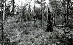 A shrubby open forest, with leaf litter forming a relatively large proportion of the ground cover, typical of this land system. |
| CLIMATE Rainfall, mean (mm) Temperature, mean (°C) Seasonal growth limitations | Annual 600 - 900; lowest July (40 - 70), highest October (60 - 90) Annual 12 - 14; lowest July (8 - 10), highest February (19 - 21) Temperature <10°C (av.): May - September Rainfall < potential evapotranspiration: December – February |
| GEOLOGY Age, lithology | Lower Carboniferous freshwater siltstones, minor sandstones, conglomerates, often red (Snowy Plains Formation) with alternating quartzose and feldspathic sandstones and 'red-bed' siltstones |
| PHYSIOGRAPHY Landscape Elevation range (m) Relative relief (m) Drainage pattern Drainage density (km/km2) | Low rounded hills and undulating terrain 60 - 520 20 - 140 Dendritic 0.7 |
| PRESENT LAND USE | Mostly uncleared: hardwood forestry (minor timber products); apiculture; bush grazing (limited); small area in Glenaladale National Park Minor proportion cleared: grazing of beef cattle and sheep |
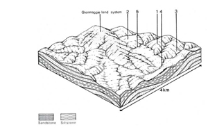 | 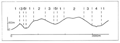 |
| LAND COMPONENT Percentage of land system Diagnostic features | 1 40 Exposed slopes and narrow, often rocky crests | 2 30 Broad, often gently undulating crests | 3 20 Protected slopes | 4 5 Flats in major drainage corridors | 5 5 Fans and associated minor drainage depressions |
| PHYSIOGRAPHY Slope %, typical and (range)
| 15-20,(10-50) Straight or concave | 5-10,(0-20) Convex | 15-20,(10-50) Concave | 2.(0-5) Straight but uneven | 2 - 5.(0-10) Straight |
| SOIL Parent material | Siltstone, quartzose and feldspathic sandstone; some conglomerate | Alluvium of variable texture | Colluvium and local alluvium | ||
| Description | Dark greyish brown, dark grey or dark brown sandy loam to clay loam topsoil abruptly overlying yellowish brown or reddish brown clay subsoil, mostly acidic and whole coloured; subsoils sometimes alkaline. Brown or greyish brown uniform loamy sand, in places shallow on or near quartzose sandstone. | Limited observations – mainly undifferentiated brown sand and loam | Duplex with yellowish brown mottled clay subsoil (on colluvium) and brown loam (on colluvium) | ||
| Classification | Yellow and Red Podzolic Soils, Solodic Soils, some Earthy Sands Dy2.21, Dy2.33, Dy3.43, Dy3.61, Dr2.11, Dr2.21, Dr3.21, Uc4.13, Uc4.24 | Alluvial Soils Uc1.24 | Yellow Podzolic Soils Dy2.22, Um1.44 | ||
| Surface texture | Sandy loams (mainly) to clay loams | - | Sandy loams to clay loams | ||
| Surface consistence | Variable: soft to hard when dry, friable to firm when moist | - | Variable | ||
| Depth (m) | Variable: 0.8-1.5 | >2.0 | >2.0 | ||
| Nutrient status | Low to moderate | Low to moderate | Low to moderate | ||
| Available soil water capacity | Low (sandy soils) to moderate | Low to moderate | Low to moderate | ||
| Perviousness to water | Slow to moderate | Moderate to rapid | Slow to moderate | ||
| Drainage | Mainly good | - | Very poor to somewhat poor | ||
| Exposed stone (%) | <10 | 0 | 0 | ||
| Sampled profile number | - | 56 | - | - | - |
| NATIVE VEGETATION Structure of vegetation and characteristic species of dominant stratum (+ Predominant species) | Open forest I. II. Often shrubby: E. macrorhyncha+. E. polyanthemos+, E. tereticornis+ or E. sieberi+; and E. baxteri often | Open forest II: E. melliodora+, E. cypellocarpa associated | Open forest II, III, often shrubby: Composition variable — E. cypellocarpa, E. globoidea, E. sieberi or E. tereticornis usually predominant; E. muellerana, E. sideroxylon and E. baxteri associated | Limited data — probably mainly open forest II, III, often shrubby of E. melliodora+, E. viminalis+ or E. radiata+ Rarely closed forest II of Acmena smithii, climbers, ferns and epiphytes | Mostly open forest II with composition variable and Including, E. bridgesiana. E. radiata,, E. viminalis Occasionally closed scrub of Melaleuca ericifolia or closed forest as for component 4 |
Disturbance | Affected process and trend | Primary resultant deterioration | Causal activities | Primary off-site process | ||
Form | Susceptibility of components | Incidence within components | ||||
| Alteration of vegetation: — reduction in leaf area, rooting depth and/or perenniality | Reduced transpiration, resulting in increased deep percolation and leaching | Nutrient loss | Not determined | Not determined |
| Increased movement of water to groundwater; increased base-flow of streams |
| Increased exposure of surface soil | Increased overland flow and soil detachment | Sheet and rill erosion | 1,3; moderate 2; low | Uncommon |
| Increased flash flows and sediment load. |
| Increased physical pressure on soil | Increased compaction with reduced infiltration | Structure decline Sheet and rill erosion | 1,2,3; low - moderate 4; low 5; moderate 1,3: moderate 2; low | Uncommon Uncommon |
As for sheet and rill erosion above | - Increased flash flows |
| Increased soil disruption | Increased soil break-up | Gully erosion Scour erosion Streambank erosion | 1,3,5; moderate 2; low 4; moderate 4; high | Uncommon Uncommon Uncommon |
As for sheet and rill erosion above. As for sheet and rill erosion above | Increased sediment load. Increased sediment load Increased sediments load and turbidity |
| Comments: - | ||||||
© State of Victoria (Agriculture Victoria) 1996 - .

This work, Victorian Resources Online, is licensed under a Creative Commons Attribution 4.0 licence. You are free to re-use the work under that licence, on the condition that you credit the State of Victoria (Agriculture Victoria) as author, indicate if changes were made and comply with the other licence terms.
The licence does not apply to ‘branding’ or some ‘images or photographs’ that may be owned by third parties. We ask you to seek prior approval to use images using the VRO feedback form. Access to higher quality images can also be provided on request.
This page was last updated on .