
Turton (Tn)
 | Area: 922 sq. km (4.5%) Turton land system occurs on the Carboniferous sediments that outcrop in the central-west of the East Victorian Uplands. The terrain is mountainous with a prominant ridge-and-ravine topography, long, steep slopes and active soil creep. Relief is high and rock outcrop abundant. There is evidence of some structural control of slope shape by the outcrop of the harder quartzose members of the sediments. Red-bed shales also outcrop and can contribute to slope failure. The valleys of the major rivers, notably the Avon, Macalister, Mitchell and Moroka Rivers have levees and alluvial terraces similar to, though smaller than, those mapped as Walnut land system. Turton is similar in geology and topography to Macalister land system but it occurs at lower elevations and is much drier. | 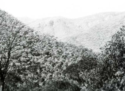 Steep, forested slopes with rock outcrop along the Licola Road |
| The more resistant sandstones and the more weatherable red-bed shales form two contrasting soil parent materials. However, the sandstones predominate and these, together with natural erosion on steep slopes, have produced shallow, stony soils. Rainfall is moderate and the soils are well-leached and acidic. Low clay content and erosion suppress profile development. Topsoils tend to have crumb structure but subsoils are usually earthy and apedal. Moisture availability is generally low but it tends to be greater on protected slopes at higher elevations. This is reflected in the vegetation which is mostly dry, shrubby open forest II grading into more vigorous, humid forests with species characteristic of moister conditions at higher elevations. | ||
| CLIMATE Rainfall, mean (mm) Temperature, mean (°C) Seasonal growth limitations |
Annual 800 - 1400; lowest January or February (40 - 80), highest October (100 - 150) Annual 8 - 12; lowest July (3 - 7), highest February (16 - 20)
Rainfall < potential evapotranspiration: December - February; occasional winter snow |
| GEOLOGY Age, lithology |
Carboniferous quartzose sandstones and red-bed shales (Snowy Plains Formation) |
| PHYSIOGRAPHY Landscape Elevation range (m) Relative relief (m) Drainage pattern Drainage density (km/km2) |
Steep mountains with ridge-and-ravine topography 100 - 1340 180 - 660 Dendritic 0.9 |
| PRESENT LAND USE |
Minor proportion cleared: grazing of beef cattle and sheep |
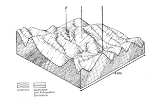 | 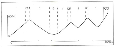 |
| LAND COMPONENT Percentage of land system Diagnostic features | 1 80 Slopes with minor structural ledges and dry forests | 2 15 Slopes with more vigorous and/or more humid forests | 3 5 Discontinuous narrow terraces on major drainage depressions |
| PHYSIOGRAPHY Slope %, typical and (range) Slope shape | 35 - 45, (10 - 100) Straight | 35 - 45, (10 - 100) Straight | Variable; (0 - 30) Straight to concave but uneven |
| SOIL | |||
| Parent material | Sandstone and shale; minor colluvium | Stony alluvium | |
| Description | Generally very shallow often stony. Dark greyish brown sandy loam to loam topsoil merging into greyish brown or reddish brown sandy loam or sandy clay loam subsoil; some yellowish brown clay subsoil. Probably more organic matter in soils of component 2 | No observations — probably light to medium textured, often stony soils | |
| Classification | Lithosols, some Red Earths and Yellow Podzolic Soils in pockets of deeper, stable soil Uc1.44, Uc4.11, Uc4.13, Urn 1.43, Urn 1.44, Um4.21, Um5.52, also Dy2.21, Dy3.21 | - | |
| Surface texture | Sandy loam to loam | - | |
| Surface consistence | Slightly hard when dry, friable when moist | - | |
| Depth (m) | <0.6, but deeper pockets | - | |
| Nutrient status | Low | >2.0 | |
| Available soil water capacity | Low | Low | |
| Perviousness to water | Moderate | Variable | |
| Drainage | Good | Moderate to rapid | |
| Exposed stone (%) | Variable; 0 - 40 | Variable | |
| Sampled profile number | - | - | |
| NATIVE VEGETATION Structure of vegetation and characteristic species of dominant stratum (+ Predominant species) | Shrubby open forest II: Higher elevations — no site data but probably E. dives+, E. rubida+ Lower elevations — generally mixed stands, species including E. consideniana, E. dives, E. goniocalyx, E. macrorhyncha, E. mannifera, E. polyanthemos E. sideroxylon, E. sieberi | Open forest II, often shrubby: Limited information — probably E. rubida+ and possibly E. delegatensis+ in the wetter areas grading into E. cypellocarpa+ and E. obliqua+; E. globoidea and E. macrorhyncha sometimes in drier sites Occasionally closed forest II of Acmena smithii, climbers, ferns and epiphytes in minor drainage lines | Mainly open forest II, III often shrubby: E. viminalis and/or E. radiata either of which may be predominant; occasionally E. melliodora+ Rarely closed forest II: Acmena smithii, vines, ferns and epiphytes |
|
|
|
|
| ||
|
|
| ||||
- reduction in leaf area, rooting depth and/or perenniality
|
resulting in: a) increased deep percolation b) increased regolith wetness Decreased root-binding |
Nutrient loss Landslip and soil creep Landslip and soil creep |
Not determined 1; moderate 2; moderate – high 1; moderate 2; moderate - high |
Not determined Uncommon: limited occurrence of old landslips near Licola Uncommon: limited occurrence of old landslips near Licola |
Removal of trees Accelerated by major disturbance of native vegetation Accelerated by major disturbance of native vegetation |
Increased movement of water to groundwater; increased base-flow of streams Increased sediment load Increased sediment load |
|
|
|
|
|
|
|
|
With Reduced infiltration |
Sheet and rill erosion |
2; low - moderate 3; moderate 1,2; moderate - high |
Common |
As for sheet and rill erosion above |
Increased flash flows |
|
|
Streambank erosion |
3; high |
Uncommon |
As for sheet and rill erosion above |
Increased sediment load |
| ||||||
© State of Victoria (Agriculture Victoria) 1996 - .

This work, Victorian Resources Online, is licensed under a Creative Commons Attribution 4.0 licence. You are free to re-use the work under that licence, on the condition that you credit the State of Victoria (Agriculture Victoria) as author, indicate if changes were made and comply with the other licence terms.
The licence does not apply to ‘branding’ or some ‘images or photographs’ that may be owned by third parties. We ask you to seek prior approval to use images using the VRO feedback form. Access to higher quality images can also be provided on request.
This page was last updated on .