
Walnut (Wt)
 | Area: 82 sq. km (0.4%) Walnut land system is mapped on the larger alluvial floors at low elevations in the East Victorian Uplands. Fluvial dynamics have been complex and a number of terraces and encroaching colluvial deposits are characteristic. Most occurrences are in the eastern half of the Uplands and they are commonly associated with areas of Dargo land system. Here they contain stored alluvium held back by resistant rock bars which form local stream base levels. Many of the major streams have levees and alluvial flats, too small to map at the scales used, but these are essentially part of the Walnut land system. Soils occurring on the younger terraces still receive sediments during floods and little soil development has taken place beyond darkening of topsoils by organic matter accumulation and some surface structural development. Subsoils still show stratification of the alluvial sediments. Due to good internal drainage, subsoils are brown and not mottled. Glistening mica flakes can often be observed and are indicative of good reserves of potash. Minor swampy areas that have soils of low permeability are associated with these younger terraces. Limited observations indicate that the older terraces have variable soils, possibly reflecting differences in age, texture and mineralogy of parent materials. Textures may become more clayey with depth as a result of soil-forming processes. Duplex and gradational soils have been observed as well as soils with little textural differentiation. On most of the older terraces, subsoils tend to be brightly coloured, ranging from yellowish brown to reddish brown and may or may not show structural development. The original vegetation, now largely cleared, appears to have been mainly open forest II and III, with closed sedgeland in swampy places. | 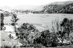 An alluvial terrace with relict stream channels, large enough to be mapped in Walnut land system, is surrounded by the partly cleared slopes of Wonnangatta land system. The forested slopes are in Talbotville land system. |
| CLIMATE Rainfall, mean (mm) Temperature, mean (°C) Seasonal growth limitations |
Annual 600 - 900; lowest July (40 - 70), highest October (60 - 90) Annual 12 - 14; lowest July (8 - 10), highest February (19 - 21) Temperature <10°C (av.): May - September Rainfall < potential evapotranspiration: November – March |
| GEOLOGY Age, lithology |
Holocene fluviatile deposits of sands, silts, some clays and gravels |
| PHYSIOGRAPHY Landscape Elevation range (m) Relative relief (m) Drainage pattern Drainage density (km/km2) |
Terraced alluvial floors at low elevations in the highlands 100 - 900 0 - 10 Sinuous channel 1.7 |
| PRESENT LAND USE |
|
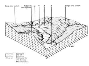 | 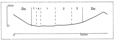 |
| LAND COMPONENT Percentage of land system Diagnostic features | 1 50 Younger lower terraces, with fluviatile forms preserved, subject to flooding | 2 30 Older higher terraces, now erosional, not flood prone | 3 10 Minor fan deposits adjacent to higher land | 4 10 Main channel, often slightly braided |
| PHYSIOGRAPHY Slope %, typical and (range) Slope shape | 1 - 2, (0 - 5) Straight but uneven | 1 - 2, (0 - 5) Straight but uneven | 15 - 25, (10 - 30) Slightly concave | <1, (0 - 2) Concave |
| SOIL | ||||
| Parent material | Alluvial sand, silt and some clay and gravel often stratified at depth | Colluvium of variable texture | - | |
| Description | Very dark greyish brown loamy sand to silty clay loam topsoil over structureless brown subsoil | Very dark greyish brown loamy sand to sandy clay loam topsoil over brown or reddish brown subsoil with variable texture and structure | Limited observations — probably mainly dark greyish brown loamy topsoil grading into or resting on yellowish brown clay subsoil, with some gravel | No soils; often gravelly bed loads |
| Classification | Alluvial Soils, minor Humic Gleys Uc5.21, Um5.52, Um6.22, Uc1.23, Uc1.43, Uml.44 | Non-calcic Brown Soils, Earthy Sands, Solodic Soils, Red-brown Earths Uc5.21, Um4.25, Um4.31, Gn3.26, Dr2.23 | Alluvial Soils Uc1.4-, Um1.4- | - |
| Surface texture | Variable; sand to clayey sand | Loamy sand to sandy clay loam | Sandy and loamy textures | - |
| Surface consistence | Loose to friable when moist | Slightly hard to very hard when dry | Slightly hard to hard when dry | - |
| Depth (m) | >2.0 | >2.0 | >2.0 | - |
| Nutrient status | Low for sands, otherwise moderate | Low to moderate | Low to moderate | - |
| Available soil water capacity | Low for sands, otherwise moderate | Low to moderate | Low to moderate | - |
| Perviousness to water | Moderate to rapid | Variable; slow to rapid | Slow | - |
| Drainage | Good | Good | Moderately good to good | - |
| Exposed stone (%) | 0 | 0 | Probably <10 | - |
| Sampled profile number | 18, 22 | 21 | - | - |
| NATIVE VEGETATION Structure of vegetation and characteristic species of dominant stratum (+Predominant species) | Open forest II, III: E. melliodora+ and/or E. viminalis+ or occasionally E. elata+; understorey often includes Melaleuca ericifolia, Leptospermum spp., Callistemon spp. Occasional swamps with closed sedgeland, usually of Carex appressa | Mainly open forest II, III: E. melliodora and/or E. viminalis predominant; E. radiata. E. ovata (in wetter areas) or E. stellulata (at higher elevations) sometimes associated | Fringing vegetation similar to component 1 | |
Disturbance | Affected process and trend | Primary resultant deterioration | Causal activities | Primary off-site process | ||
Form | Susceptibility of components | Incidence within components | ||||
| Alteration of vegetation: — reduction in leaf area, rooting depth and/or perenniality | Reduced transpiration, resulting in increased deep percolation | Nutrient loss | Not determined | Not determined | Removal of trees | Increased movement of water to groundwater; increased base-flow of streams' |
| Increased exposure of surface soil | Increased overland flow and soil detachment | Sheet and rill erosion | 1,2; low 3; moderate | Uncommon | Clearing, cultivation, overgrazing, road and dam building and other earth-moving activities, trafficking by stock and vehicles. | Increased sediment load and stream flow |
| Increased physical pressure on soil | Increased compaction | Structure decline | 1,2; low - moderate 3; low | Uncommon | Increased trafficking, cultivation, overgrazing, export of organic matter | - |
| Increased soil disruption | Increased soil break-up | Gully erosion Scour erosion Streambank erosion | 3; moderate 1; high 1; high | Uncommon Common: locally severe Common: partly a natural process | As for sheet and rill erosion above As for sheet and rill erosion above As for sheet and rill erosion above | Increased sediment load and streamflow Increased sediment load and streamflow Increased sediment load and streamflow |
| Comments: Regeneration of vegetative cover is usually rapid because of high soil fertility and high moisture availability. However, engineering works may be required to help restore vegetation on eroded streambanks | ||||||
© State of Victoria (Agriculture Victoria) 1996 - .

This work, Victorian Resources Online, is licensed under a Creative Commons Attribution 4.0 licence. You are free to re-use the work under that licence, on the condition that you credit the State of Victoria (Agriculture Victoria) as author, indicate if changes were made and comply with the other licence terms.
The licence does not apply to ‘branding’ or some ‘images or photographs’ that may be owned by third parties. We ask you to seek prior approval to use images using the VRO feedback form. Access to higher quality images can also be provided on request.
This page was last updated on .