
Soil/Landform Unit 94
Landform Unit Description
Page top
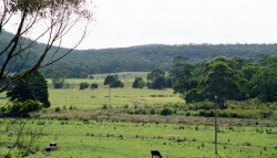
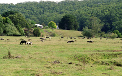 Depositional terrace near Chapple Vale at the juncation of the Gellibrand and Chapple rivers |
0.18% of CMA region High level river terrace systems have developed along the Gellibrand River valley at Carlisle River, Gellibrand and Chapple Vale. Up to four different levels can be found, and mild dissection on the upper levels results in quite complicated landscapes. The alluvial material varies from coarse sands and gravels to silts and clays, and a variety of soils is found at different levels. Redistribution of sand over some areas has resulted in polygenetic soils with hardpan development. This further complicates the soil and vegetation pattern. Most of these terrace systems have been cleared, with dairying being the major land use. Seasonal waterlogging is common and soil compaction may result from cattle grazing these areas in wet conditions. |  |
 Depositional terrace of Coles Creek | 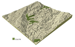 |
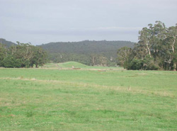
 |  Terrace and floodplain of the Gellibrand River |
Component | 1 | 2 | 3 | 4 | 5 | 6 | 7 |
Proportion of soil-landform unit | 10% | 10% | 10% | 10% | 15% | 25% | 20% |
| CLIMATE Rainfall (mm) | Annual: 1000-1150, lowest January (45), highest August (130) | ||||||
| Temperature (oC) | Annual: 13, lowest July (8), highest February (8) | ||||||
| Seasonal growth limitations | Temperature: less than 10oC (av.) June-September Precipitation: less than potential evapotranspirational mid November-late March | ||||||
| GEOLOGY Age and lithology | Recent alluvial clay, silt and sand shallowly overlyign unconsolidated Paleogene sand with some clay and silt | ||||||
| Geomorphology | |||||||
| LANDUSE | Cleared areas: Dairy farming; beef cattle grazing; open-range pig fattening; residential; water supply Uncleared areas: Sand and gravel extraction; water supply; minor forest produce | ||||||
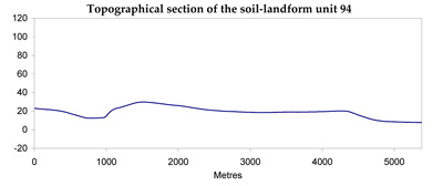
| TOPOGRAPHY Landscape | Elevated and, in parts, uplifted and dissected system of ancient cut and depositional terraces of the Gellibrand River | ||||||
| Elevation range (m) | 30-180 | ||||||
| Local relief (m) | 20 | ||||||
| Drainage pattern | Dendritic pattern in dissected areas; internal drainage elsewhere | ||||||
| Drainage density (km/km2) | 2.2 | ||||||
| Landform | Alluvial terraces | Scarps | Valley floors | Scarps | Mildly dissected alluvial terraces | ||
| Landform element | Low level | - | - | - | Mid level | - | High level |
| Slope and range (%) | 3 (0-8) | 25 (15-40) | 0 (0-1) | 15 (3-35) | 5 (0-9) | 3 (0-5) | 7 (1-10) |
| Slope shape | Linear | Linear | Linear | Convex | Linear | Linear | Convex |
| NATIVE VEGETATION Structure | Open forest | Open forest | Tall open forest | Woodland | Low open woodland | Open forest | Open forest |
| Dominant species | E. obliqua, E. ovata | E. obliqua, E. viminalis | E. viminalis, E. obliqua, Acacia melanoxylon, E. ovata | E. radiata, E. nitida, E. baxteri, E. viminalis | E. nitida, E. radiata, E. baxteri | E. aromaphloia, E. radiata, E. ovata | E. obliqua, E. radiata, E. baxteri |
| SOIL Parent material | Alluvial clay, silt, some sand | Sand, silt and clay | Alluvial clay, silt and sand | Sand | Sand | Alluvial clay, silt wtih sand underlay | Alluvial clay, silt |
| Description (Corangamite Soil Group) | Yellow-brown gradational soils coarse structure (34) | Grey gradational soils (34) | Grey sand soils with hardpans (29) | Grey sand soils, structured clay underlay (11) | |||
| Soil type sites | OTR750 | OTR497, OTR741 | OTR733 | OTR742, OTR426 | OTR737 | OTR746 | |
| Surface texture | Fine sandy loam | Sandy oam | Sandy clay loam | Loamy sand | Silty loam | Sandy loam | Sandy loam |
| Permeability | Low | High | Low | Very high | Very low | Low | Moderate |
| Depth (m) | >2 | >2 | >2 | >2 | 0-1 | >2 | >2 |
| LAND CHARACTERISTICS, POTENTIAL AND LIMITATIONS | Low permeability and high rainfall lead to seasonally high watertables with resulting waterlogging and water compaction. | Low inherent fertility and high permeability lead to leaching of nutrients. Weakly structured surface soils on the steepest slopes are prone to sheet erosion. Saturation of clay subsoils on steep slopes lead to landslips. | Flooding and seasonal watertable development lead to waterlogging, soil compaction and siltation. | Very low inherent fertility and high permeability lead to nutrient decline. Steeper slopes with compaction soils of low water holding capacity are prone to sheet erosion. | Very low inherent fertility with leaching of permeable acidic surfaces leads to nutrient decline. Hardpans restrict drainage, leading to seasonal waterlogging. | Low inherent fertility with leaching of permeable surface horizons lead to nutrient decline. Low profile permeability and perched seasonal watertables lead to waterlogging. | Low inherent fertility and phosphorus fixation lead to nutrient decline. |
© State of Victoria (Agriculture Victoria) 1996 - .

This work, Victorian Resources Online, is licensed under a Creative Commons Attribution 4.0 licence. You are free to re-use the work under that licence, on the condition that you credit the State of Victoria (Agriculture Victoria) as author, indicate if changes were made and comply with the other licence terms.
The licence does not apply to ‘branding’ or some ‘images or photographs’ that may be owned by third parties. We ask you to seek prior approval to use images using the VRO feedback form. Access to higher quality images can also be provided on request.
This page was last updated on .