
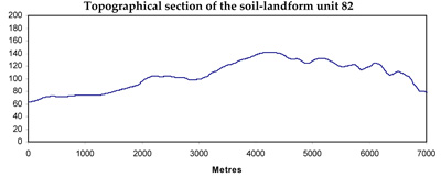
Soil/Landform Unit 82
Landform Unit Description
Page top
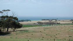
 Looking east along the Drysdale-St Leonards Road over Neogene sources plains and rises |
0.30% of CMA region This unit of undulating rises and plains includes a few occurrences on the Bellarine Peninsula as a dunefield in the Curlewis area sitting on Neogene terrain (plateau) and to the south of Portarlington at a lower elevation east of the Neogene plateau. Unit components comprise dunes and depressions. The soils are sands (Tenosols, Podosols) or sands over clay (Sodosols) The steep dunes are very rapidly drained but susceptible to wind and sheet erosion, particularly where vegetation cover is removed. Nutrient decline (retention) is also a susceptibility. Land use is grazing (sheep and beef), minor cropping, recreation and mineral extraction. | 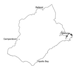 |
 Dune at Curlewis golf club | 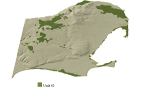 |
 | Looking south-east over rises and plains north of St Leonards |
Component | 1 | 2 |
Proportion of soil-landform unit | 70% | 30% |
| CLIMATE Rainfall (mm) | Annual: 610 | |
| Temperature (oC) | Minimum 10, Maximum 19 | |
| Precipitation les than potential evapotranspiration | October-April | |
| GEOLOGY Age and lithology | ||
| Geomorphology | ||
| LANDUSE | Uncleared areas: Nature conservation; active and passive recreation Cleared areas: Sheep and beef cattle grazing; minor cropping (cereal); regional development | |
| TOPOGRAPHY Landscape | Undulating rises and plains | |
| Elevation range (m) | 1-95 | |
| Local relief (m) | 2-15 | |
| Drainage pattern | Dendritic-parallel | |
| Drainage density (km/km2) | 0.7 | |
| Landform | Dunes | |
| Landform element | Dune | Depression |
| Slope and range (%) | 10 (0-25) | 3 (0-10) |
| Slope shape | Straight | Concave |
| NATIVE VEGETATION Ecological Vegetation Class | Coastal Dune Scrub Mosaic (4.1%, Coastal Saltmarsh (3.9%), Grassy Woodland (2.6%), Heathy Woodland (1.9%), Calcarenite Dune Woodland (1.7%), other (1.4%) | |
| SOIL Parent material | Sand, minor silt and clay | Sand, silt and clay |
| Description (Corangamite Soil Group) | ||
| Soil type sites | ||
| Surface texture | Loamy sand | Sandy loam |
| Permeability | Very high | High |
| Depth (m) | >2 | >2 |
| LAND CHARACTERISTICS, POTENTIAL AND LIMITATIONS | Deep sands or sands over clay. Often unconolidated material with low water and nutrient holding capacity in sands. Susceptible to sheet and wind erosion. | Deep sands or sands over clay or texture contrast. Oten unconsolidated material with low water and nutrient holding capacity in sands or lighter upper soil. Susceptible to sheet and wind erosion. |
© State of Victoria (Agriculture Victoria) 1996 - .

This work, Victorian Resources Online, is licensed under a Creative Commons Attribution 4.0 licence. You are free to re-use the work under that licence, on the condition that you credit the State of Victoria (Agriculture Victoria) as author, indicate if changes were made and comply with the other licence terms.
The licence does not apply to ‘branding’ or some ‘images or photographs’ that may be owned by third parties. We ask you to seek prior approval to use images using the VRO feedback form. Access to higher quality images can also be provided on request.
This page was last updated on .