
CLRA07
Location: Drysdale district, Bellarine Peninsula
Australian Soil Classification: Melacic, Sesquic, Aeric, PODOSOL
General Landscape Description: Crest of Dunes unit.
Geology: Quaternary Aeolian: coastal and inland dunes: dune sand, some swamp deposits
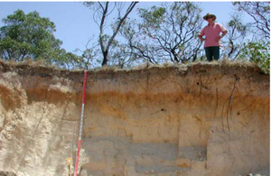
CLRA7 Landscape. Cutting in side of dune at Curlewis Golf Club
Soil Profile Morphology:
Surface Soil
A11 | 0–10 cm | Very dark grey (10YR3/1); loamy sand; weak medium sub-angular blocky structure; rough fabric; very weak consistence dry; pH 4.5; smooth clear boundary to: | 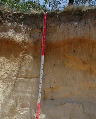 CLRA7 Profile | |||
A12 | 10–20 cm | Very dark grey (10YR3/1); light loamy sand; apedal single grain structure; sandy fabric; very weak consistence dry; pH 4.5; smooth gradual boundary to: | ||||
A2 | 20–50 cm | Light yellowish brown (10YR6/3), conspicuous bleach (10YR7/2); sand; apedal single grain structure; sandy fabric; very weak consistence dry; pH 5.0; wavy clear boundary to: | ||||
Subsoil | ||||||
Bhs | 50–90 cm | Brown (7.5YR4/3); heavy sand; apedal massive structure; sandy fabric; very weak consistence dry; pH 6.0; wavy diffuse boundary to: | ||||
C1 | 90–140 cm | Yellowish brown (10YR5/4); sand; apedal single grain structure; sandy fabric; very weak consistence dry; few argillaceous laminae; pH 6.0; wavy diffuse boundary to: | ||||
C2 | 140–195 cm | Very pale brown (10YR7/4); sand; apedal massive structure; sandy fabric; weak consistence dry; few argillaceous laminae; pH 7.0; wavy diffuse boundary to: | ||||
C3 | 195–210+ cm | Brownish yellow (10YR6/8); sand; apedal massive structure; sandy fabric; strong consistence dry; pH 6.5. | ||||
Soil Profile Characteristics:
Horizon | Sample Depth (cm) | pH (water) | pH (CaCl2) | EC 1:5 | Exchangeable Cations | |||
Ca | Mg | K | Na | |||||
meq/100g | ||||||||
A11 | 0–10 | 4.8 | 3.9 | 0.09 | 1.9 | 1.4 | 0.21 | 0.25 |
A12 | 10–20 | 4.6 | 3.8 | 0.05 | 0.8 | 0.5 | 0.1 | 0.13 |
A2 | 20–50 | 4.6 | 4 | <0.05 | 0.38 | 0.26 | 0.05 | 0.08 |
Bhs | 50–90 | 5.4 | 4.6 | <0.05 | 0.49 | 0.43 | 0.1 | 0.09 |
C1 | 90–140 | 5.9 | 5.2 | <0.05 | 0.22 | 0.42 | <0.05 | 0.08 |
C2 | 140–195 | 5.9 | 5.1 | <0.05 | - | - | - | - |
C3 | 195+ | 6.3 | 5.2 | 0.13 | 0.47 | 2.1 | 0.13 | 0.95 |
Horizon | Sample Depth (cm) | Organic Carbon % | Exchangeable Aluminium mg/kg | Exchangeable Acidity cmolc/kg | Field Capacity pF2.5 | Wilting Point pF4.2 | Coarse Sand (0.2- 2.0 mm) | Fine Sand (0.02- 0.2 mm) | Silt (0.002- 0.02 mm) | Clay (<0.002 mm) |
A11 | 0–10 | 5.5 | 16 | 10 | 12.3 | 12.7 | 16.6 | 74.9 | 1 | 3 |
A12 | 10–20 | 2.9 | 28 | 6.2 | 8.1 | 3.5 | 14.8 | 71 | 4.5 | 8.5 |
A2 | 20–50 | 23 | 2.4 | 9.2 | 1.6 | 16.6 | 71.3 | 6.5 | 4 | |
Bhs | 50–90 | 32 | 2.9 | 9.7 | 1.8 | 13.1 | 83.2 | 0.5 | 4 | |
C1 | 90–140 | <10 | - | 7.3 | 0.8 | 13.5 | 82.6 | 0.5 | 1.5 | |
C2 | 140–195 | - | 5.9 | 0.5 | 30.4 | 66.2 | 0 | 2 | ||
C3 | 195+ | 1 | 7.2 | 2.8 | 34.1 | 55.1 | 0.5 | 9.5 |
Management Considerations:
- This soil has a strong consistence contrast between the loose/weakly coherent deep sandy soil and the coherent subsoil which is sodic.
- It is important to maintain or improve the upper soil by increasing organic matter (particularly in the subsurface soil). The organic carbon content of the upper surface (A11) is 5.5% and the surface (A12) is 2.9%. This surface organic layer is important for soil stability as is the maintenance of a vegetative cover is important particularly where the surface soil is light and susceptible to water and wind erosion and variable slope (dunefield in this case).
- Root penetration of the “coffee rock” at depth may be difficult with the hardsetting nature of the layer, but the sandy soil above provides a suitable physical medium for growth though with little water and nutrient holding capacity.
Profile Described By: David Rees (December 2002).
© State of Victoria (Agriculture Victoria) 1996 - .

This work, Victorian Resources Online, is licensed under a Creative Commons Attribution 4.0 licence. You are free to re-use the work under that licence, on the condition that you credit the State of Victoria (Agriculture Victoria) as author, indicate if changes were made and comply with the other licence terms.
The licence does not apply to ‘branding’ or some ‘images or photographs’ that may be owned by third parties. We ask you to seek prior approval to use images using the VRO feedback form. Access to higher quality images can also be provided on request.
This page was last updated on .