
Soil/Landform Unit 78
Landform Unit Description
Page top
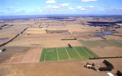 Undulating plains and rises outh-east of Colac |
1.38% of CMA region An extensive ferruginised plateau to the north of the Otway Range has been dissected by the Barwon River and its tributaries. There are several plateau remnants separated by the alluvial plains of the Barwon River. In general, flat or gently undulating plains occupy the highest parts of the landscape, and these are surrounded by gentle slopes leading to slightly lower surfaces or by steep scarps falling away to the alluvial plains. The area to the west of the Barwon River is more dissected, with generally steeper slopes. The soils on the highest levels have been strongly ferruginised, with ferricrete throughout the profile and concentrated in discontinuous layers at about 1.2 m depth. Similar soils without ferricrete are found on lower levels, while the gentle slopes between these levels possess heavier textured soils with coarse blocky structures in the subsoils. Clearing has been widespread and the land is used for sheep and beef cattle grazing as well as some dairying. Soil salting has occurred in some areas, and major problems have arisen due to gully and tunnel erosion. The more dissected areas to the west of the Barwon River are the most susceptible, and damage has been widespread. | 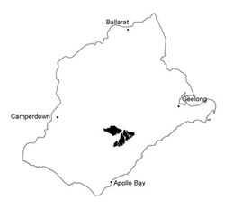 |
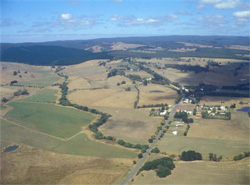 Undulating rises at Deans Marsh | 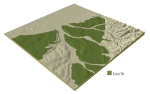 |
 | 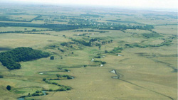 Scarp and remnant plateau bordering the Barwon River |
Component | 1 | 2 | 3 | 4 | 5 | 6 |
Proportion of soil-landform unit | 40% | 15% | 20% | 10% | 7% | 8% |
| CLIMATE Rainfall (mm) | Annual: 650-700, lowest January (30), highest August (85) | |||||
| Temperature (oC) | Annual: 13, lowest July (8), highest February (9) | |||||
| Seasonal growth limitations | Temperature: less than 10oC (av.) June-August Precipitation: less than potential evapotranspiration early October-late April | |||||
| GEOLOGY Age and lithology | Neogene marine marl and calcarenite, and fluvio-marine sand, Recent clay, sand and gravel, Paleogene fluvial sand | |||||
| Geomorphology | ||||||
| LANDUSE | Cleared areas: Sheep and beef cattle grazing; cash and row cropping; dairy farming | |||||
| TOPOGRAPHY Landscape | Undulating plain inalnd of the Otway Range | |||||
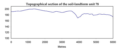
| Elevation range (m) | 120-190 | |||||
| Local relief (m) | 40 | |||||
| Drainage pattern | Dendritic | |||||
| Drainage density (km/km2) | 1.5 | |||||
| Landform | Hills | High level terraces | Drainage lines | Scarps | ||
| Landform element | Broad crest | Gentle upper slope | Gentle broad slope | - | - | - |
| Slope and range (%) | 1 (0-2) | 5 (2-10) | 3 (0-7) | 0 (0-1) | 35 (10-50) | |
| Slope shape | Linear | Linear | Convex linear | Concave | Linear, convex | |
| NATIVE VEGETATION Structure | Open forest | Open forest | Open forest | Woodland | Closed scrub | Open forest |
| Dominant species | E. viminalis, E. obliqua, E. radiata | E. viminalis, E. ovata | E. obliqua, E. viminalis, E. ovata, E. radiata | E. viminalis, E. obliqua, E. ovata | Leptospermum juniperinum, Melaleuca squarrosa | E. obliqua, E. viminalis |
| SOIL Parent material | Ferruginised sediments | Clay | Clay, silt and sand | Alluvial clay, silt and sand | Alluvial clay, silt and sand | Clay, silt and sand |
| Description (Corangamite Soil Group) | Mottled brown, grey, yellow and red texture contrast soils (13) | Grey gradational soils (34) | Brown, grey and yellow sodic texture contrast soils (32) | |||
| Soil type sites | OTR492, OTR744, SW67 | OTR733 | ||||
| Surface texture | Sandy loam | Fine sandy loam | Sandy loam | Fine sandy loam | Fine sandy clay loam | Sandy loam |
| Permeability | Moderate | Low | Moderate | Low | Very low | Moderate |
| Depth (m) | 1-2 | >2 | >2 | >2 | >2 | >2 |
| LAND CHARACTERISTICS, POTENTIAL AND LIMITATIONS | Low inherent fertility, phosphate fixation, and permeable surface soils lead to nutrient decline. | Dispersible clay subsoils of low permeability are prone to gully and tunnel erosion. Sodic subsoils of low permeability receiving saline seepage are prone to soil salting. | Low inherent fertility, phosphate fixation and permeable surface soils lead to nutrient decline. | Dispersible clay subsoils of low permeability are prone to gully and tunnel erosion and soil salting. | High seasonal watertable leads to waterlogging, soil compaction and soil salting. Dispersible clay subsoils are prone to gully and tunnel erosion. | Dispersible soils on steep slopes subject to periodic saturation are prone to landslips and sheet erosion. |
© State of Victoria (Agriculture Victoria) 1996 - .

This work, Victorian Resources Online, is licensed under a Creative Commons Attribution 4.0 licence. You are free to re-use the work under that licence, on the condition that you credit the State of Victoria (Agriculture Victoria) as author, indicate if changes were made and comply with the other licence terms.
The licence does not apply to ‘branding’ or some ‘images or photographs’ that may be owned by third parties. We ask you to seek prior approval to use images using the VRO feedback form. Access to higher quality images can also be provided on request.
This page was last updated on .