
Soil/Landform Unit 67
Landform Unit Description
Page top
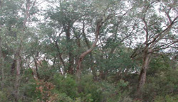
 Pocket of cleared land on an upper slope overlooking uncleared open forest |
0.25% of CMA region Deeply dissected hills north and west of Gellibrand possess Paleogene sands and clays on the higher parts of the landscape and outcrops of Cretaceous sediments on the steeper and lower parts. The soils become heavier and more fertile on the Cretaceous sediments and this is reflected in the occurrence of Eucalyptus obliqua and E. viminalis open forests with dense understoreys. Most areas are too steep for agriculture, and remain forested with native hardwoods or pines. Clearing operations necessary for pine conversion and hardwood harvesting may result in severe scour gullying and landslips on the steep parts of the landscape. Access tracks are difficult to site and prone to scouring. In general, careful land management is required. | 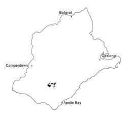 |
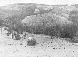 The steep land and irregular nature of the terrain makes these areas difficult to manage | 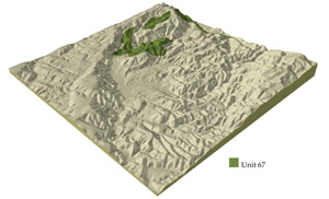 |
 |  Low woodland of the gentle slopes |
Component | 1 | 2 | 3 | 4 | 5 |
Proportion of soil-landform unit | 25% | 20% | 40% | 9% | 6% |
| CLIMATE Rainfall (mm) | Annual: 900-1050, lowest January (45), highest August (130) | ||||
| Temperature (oC) | Annual: 12, lowest July (7), highest February (18) | ||||
| Seasonal growth limitations | Temperature: less than 10oC (av.) June-August Precipitation: less than potential evapotranspiration early November-late March | ||||
| GEOLOGY Age and lithology | Paeogene unconsolidated marine sand, silt and clay | Lower Cretaceous sandstone and mudstone | Paleogene unconsolidated carbonaceous sand, silt and clay | ||
| Geomorphology | |||||
| LANDUSE | Uncleared areas: Hardwood forestry for posts and ples, some sawlogs on better soils; nature conservation; water supply; gravel extraction; softwood plantations Cleared areas: Beef cattle and sheep grazing on mainly unimproved pastures; water supply | ||||
| TOPOGRAPHY Landscape | Deeply dissected hills abutting the Gellibrand River to teh west of Love Creek | ||||
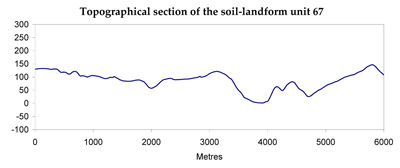
| Elevation range (m) | 60-290 | ||||
| Local relief (m) | 95 | ||||
| Drainage pattern | Dendritic with some radial areas | ||||
| Drainage density (km/km2) | 2.2 | ||||
| Landform | Hills | ||||
| Landform element | Crest and upper slope | Slope | Steep lower slope | Gentle slope | Broad crest and upper slope |
| Slope and range (%) | 20 (5-35) | 30 (20-35) | 45 (30-65) | 15 (4-20) | 13 (1-20) |
| Slope shape | Convex | Convex | Linear | Concave | Convex |
| NATIVE VEGETATION Structure | Woodland | Open forest | Open forest | Low woodland | Woodland |
| Dominant species | E. nitida, E. radiata, E. baxteri | E. baxteri, E. obliqua | E. obliqua, E. ovata, E. viminalis, E. aromaphloia on southern aspect E. cypellocarpa | E. nitida, E. ovata, E. baxteri | E. radiata, E. baxteri, E. nitida, E. obliqua |
| SOIL Parent material | Sand | Sand, silt and clay | In situ weathered rock | Sand | Quartz gravel, some clay, sand and silt |
| Description (Corangamite Soil Group) | Grey sand soils (29) | Brown gradational soil (7) | Grey sand soils with hardpans (29) | Stony brown, grey or yellow gradational soils (29) | |
| Soil type sites | OTR742 | OTR479, OTR741 | - | ||
| Surface texture | Loamy sand | Sandy loam | Loam | Loamy sand | Loamy sand |
| Permeability | Very high | High | Moderate | Very low | Very high |
| Depth (m) | >2 | >2 | 0-9 | 0-5 | >2 |
| LAND CHARACTERISTICS, POTENTIAL AND LIMITATIONS | Low inherent fertility and high permeability lead to nutrient decline. Weakly structured surface soils are prone to sheet erosion on steeper slopes. | Steeper slopes are prone to sheet and rill erosion. Clay subsoils subject to periodic saturation are prone to landslips. | Low inherent fertility leads to nutrient decline. Hardpans restrict vertical drainage leading to seasonal waterlogging. | Very low inherent fertility and high permeability lead to leaching and nutrient decline. | |
© State of Victoria (Agriculture Victoria) 1996 - .

This work, Victorian Resources Online, is licensed under a Creative Commons Attribution 4.0 licence. You are free to re-use the work under that licence, on the condition that you credit the State of Victoria (Agriculture Victoria) as author, indicate if changes were made and comply with the other licence terms.
The licence does not apply to ‘branding’ or some ‘images or photographs’ that may be owned by third parties. We ask you to seek prior approval to use images using the VRO feedback form. Access to higher quality images can also be provided on request.
This page was last updated on .