
Soil/Landform Unit 66
Landform Unit Description
Page top
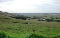 Steep slopes denote the margin of the Redwater Creek landscape with the floodplains of the Gellibrand River at Glenaire |
0.42% of CMA Region In the southern parts of the Otway Range, gentle hill cappings of Paleogene quartzitic sands occur as remnants on the high parts of the landscape. Most creeks and rivers have dissected through these sands, exposing Cretaceous sandstone and mudstone on steep slopes leading down to the drainage lines. The capping of sand overlies Cretaceous sediments at a fairly shallow and uniform depth. The native vegetation on the sands is not dissimilar from that on the surrounding brown gradational soils, consisting of tall open forests of Eucalyptus obliqua, E. cypellocarpa and E. regnans on the better sites. These tall trees apparently extract nutrients from underlying weathering Cretaceous rocks. Nutrient cycling by leaf fall and decay has built up the fertility of the sands, far above that normally encountered on such parent material. Only minor parts of this unit have been cleared and it appears that a marked decline in soil fertility has resulted. Hardwood and softwood forestry is the main land use, together with a small industry in the cutting of tea-tree stakes. | 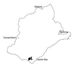 |
 Harvested pine plantation is now replaced with blue gums | 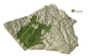 |
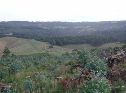
 | 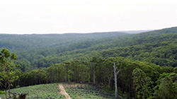 Forests of the Ford River valley |
Component | 1 | 2 | 3 | 4 | 5 |
Proportion of soil-landform unit | 5% | 40% | 5% | 25% | 25% |
| CLIMATE Rainfall (mm) | Annual: 1150-1600, lowest January (60), highest August (160) | ||||
| Temperature (oC) | Annual: 12, lowest July (7), highest February (16) | ||||
| Seasonal growth limitations | Temperature: less than 10oC (av.) June-September Precipitation: less than potential evaportranspiration December-mid February | ||||
| GEOLOGY Age and lithology | Paleocene unconsolidated quartz sand and gravel shallowly underlain by Lower Cretaceous sandstone and mudstone | Lower Cretaceous sandstone and mudstone | |||
| Geomorphology | |||||
| LANDUSE | Uncleared areas: Hardwood forestry for sawlogs and pulpwood; tea-tree stake harvesting; nature conservation; sand and gravel extraction Minor cleared areas: Beef cattle grazing on unimproved pastures | ||||
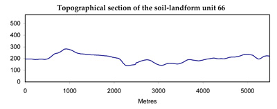
| TOPOGRAPHY Landscape | Deeply dissected hills with broad gentle hill cappings in the southern parts of the Otway Range | ||||
| Elevation range (m) | 15-370 | ||||
| Local relief (m) | 90 | ||||
| Drainage pattern | Dendritic with some radial areas | ||||
| Drainage density (km/km2) | 3.7 | ||||
| Landform | Rises | Scarps | |||
| Landform element | Crest | Crest and upper slope | Swale | Crest and upper slope | Steep slope |
| Slope and range (%) | 4 (1-7) | 20 (3-35) | 3 (1-5) | 8 (3-15) | 35 (10-60) |
| Slope shape | Linear | Convex | Concave | Irregular | Linear |
| NATIVE VEGETATION Structure | Woodland | Tall open forest | Closed forest | Open forest | Tall open forest |
| Dominant species | E. nitida, E. baxteri | E. obliqua, E. cypellocarpa, E. regnans, E. viminalis | Leptospermum juniperinum | E. regnans, E. obliqua, E. baxteri, occasionally E. viminalis | E. obliqua, E. regnans, E. cypellocarpa, E. viminalis |
| SOIL Parent material | Deep deposits of quartz sand | Shallow deposits of quartz sand | Alluvial sand and gravel, organic matter | Shallow deposits of quartz sand and gravel | In situ wathered sandstone and mudstone |
| Description (Corangamite Soil Group) | Grey sand soils with hardpans (29) | White sand soils (29) | Brown gradational soils (7) | ||
| Soil type sites | OTR609, OTR739 | OTR609, OTR739 | OTR414, OTR416, OTR748 | ||
| Surface texture | Loamy sand | Sandy loam | Silty loam | (Gravelly) loamy sand | Sandy clay loam |
| Permeability | Low | High | Moderate | Very high | Moderate |
| Depth (m) | 1.2 | >2 | >2 | >2 | 1.4 |
| LAND CHARACTERISTICS, POTENTIAL AND LIMITATIONS | Soils of high permeabiity in high rainfall areas are prone to nutrient decline. Steeper slopes with compacted soils (tracks, clear-felled areas) are prone to sheet and rill erosion. | High watertables lead to waterlogging. Runoff from adjacent hills leads to flooding and siltation. | Soils of very low inherent fertility, low nutrient holding capacity and high permeability in high rainfall areas are prone to nutrient decline. | Clay subsoils on steeper slopes are subject to periodic saturation and are prone to landslips. Steeper slopes are prone to sheet erosion. | |
© State of Victoria (Agriculture Victoria) 1996 - .

This work, Victorian Resources Online, is licensed under a Creative Commons Attribution 4.0 licence. You are free to re-use the work under that licence, on the condition that you credit the State of Victoria (Agriculture Victoria) as author, indicate if changes were made and comply with the other licence terms.
The licence does not apply to ‘branding’ or some ‘images or photographs’ that may be owned by third parties. We ask you to seek prior approval to use images using the VRO feedback form. Access to higher quality images can also be provided on request.
This page was last updated on .