
CLRA13
|
| CLRA13 | 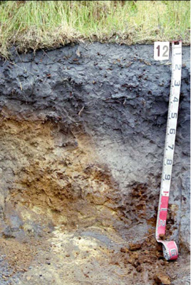 Melacic-parapanic, Humosesquic, Semi-aquic Podosol | |
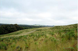
| Deans Marsh (Cemetery Road), Otway Ranges, south-west Victoria | |||
| Hills | |||
| Paleogene Eastern View Formation: fluvial gravel, sand, clay, brown coal | |||
| Upper slope | |||
| 20% | |||
| East-north-east | |||
Horizon | Depth (cm) | Description | ||
Ah | 0–25/60 | Black (10YR2/1), grey (10YR5/1 dry); loamy sand; apedal single grain structure; very weak consistence (moist); pH 5.0; clear irregular boundary to: | ||
A2 | 25/60–30/130 | Grey (10YR6/1), light grey (10YR7/1dry); loamy sand; apedal single grain structure; very weak consistence (moist); pH 5.5; abrupt broken boundary to: | ||
B21s | 40/55–85 | Yellowish brown and dark yellowish brown (10YR5/8, 10YR4/6); loamy sand; apedal single grain structure; very weak consistence (moist); pH 6.0; abrupt broken boundary to: | ||
B22s | 85/130–+ | Very dark brown (10YR2/2); apedal massive structure; very strong consistence; weakly cemented ortstein; pH 6.0. | ||
| Management considerations | ||||
This sandy soil is also acidic meaning that the nutrient holding and waterholding capacity of the soil would be considered low. However the organic matter levels in the surface (6.5% OM) provides increased capacity for nutrient and water storage. The low pH means that nutrient availability is low and that aluminium and iron become more available/prevalent. The high clay content by laboratory determination of the surface soil is not consistent with the field texture and may indicate sample contamination. The light textures of this soil do not allow for the measurement of fine particle (silt and clay) stability (Emerson test). Where exposed this material is easily moved (little cohesion). For management the depth of free draining material is important as is the variability of topsoil/soil depth. This soil varies in surface soil depth and is restricted at 85cm by a “coffee rock” horizon, restricting some downward drainage, promoting some lateral flow. | ||||
Site CLRA13 | Sample depth | pH | EC | NaCl | Ex Ca | Ex Mg | Ex K | Ex Na | Ex Al | Ex Acidity | FC –10kPa | PWP –1500kPa | KS | FS | Z | C | |
Horizon | cm | H2O | CaCl2 | dS/m | % | cmolc/kg | cmolc/kg | cmolc/kg | cmolc/kg | mg/kg | cmolc/kg | % | % | % | % | % | % |
Ah | 0–15 | 4.6 | 3.9 | 0.06 | N/R | 1.9 | 0.45 | 0.2 | 0.11 | 53 | 11 | 18.3 | 4.2 | 2.6 | 36.2 | 18 | 37.5 |
A2 | 60–80 | 4.5 | 3.9 | <0.05 | N/R | 0.12 | 0.05 | 0.05 | <0.05 | 21 | 1.4 | 13 | 0.6 | 23.2 | 62.5 | 11.5 | 3 |
B21s | 60–80 | 5.5 | 4.9 | <0.05 | N/R | 0.58 | 0.15 | 0.11 | 0.09 | 46 | 9.7 | 14 | 3.0 | 24 | 56.6 | 4 | 11 |
B22s | 80–120 | 5.4 | 4.7 | <0.05 | N/R | 0.5 | 0.26 | 0.13 | 0.1 | 94 | 13 | 20.6 | 4.6 | 21.5 | 52.8 | 7.5 | 13 |
© State of Victoria (Agriculture Victoria) 1996 - .

This work, Victorian Resources Online, is licensed under a Creative Commons Attribution 4.0 licence. You are free to re-use the work under that licence, on the condition that you credit the State of Victoria (Agriculture Victoria) as author, indicate if changes were made and comply with the other licence terms.
The licence does not apply to ‘branding’ or some ‘images or photographs’ that may be owned by third parties. We ask you to seek prior approval to use images using the VRO feedback form. Access to higher quality images can also be provided on request.
This page was last updated on .