
3.1.2 Deeply dissected upland ranges of the Southern Uplands
|
On both sides of the Otway Range divide rugged topography has developed comprising ridges and spurs separated by deeply dissected steep valleys. The drainage is strongly controlled by the geological structure. Parallel to the south-east coast, the drainage is generally south-east and north-west, whereas west of Mount Sabine, the drainage is generally north and south. The depth of dissection lessens towards the ridge, while the south-eastern flanks of the ranges have developed the steepest topography, probably in response to the fluctuations in sea level over the past million years that have changed the base level of the rivers and streams that drain the landscapes. The fluctuation in sea level and the associated uplift of the Otway Ranges has resulted in the rapid erosional processes that has transpired in numerous large landslides, with probably more activity in the past 6000 years since the slight drop in stream base levels (renewed erosion) and warmer (and therefore wetter) climates have prevailed (Dahlhaus & Miner 2002). | 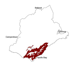 |
Soil-landform unit | Original unit ID | Unit description | Area (km2) |
| Aire L.S. | Deeply dissected hills (Otway Range) | 768 | |
| Cape Otway L. S. | Elevated longitudinal coastal dunes | 15 | |
| Forrest L.S. | Deeply dissected hills (Otway Range) | 143 | |
| Lorne L.S. | Deeply dissected hills (Otway Range) | 209 | |
| Yahoo Creek L. S. | Deeply dissected hills (north of Gellibrand River) | 32 | |
| Redwater Creek L.S. | Deeply dissected hills with broad capping (Otway Range) | 57 |
© State of Victoria (Agriculture Victoria) 1996 - .

This work, Victorian Resources Online, is licensed under a Creative Commons Attribution 4.0 licence. You are free to re-use the work under that licence, on the condition that you credit the State of Victoria (Agriculture Victoria) as author, indicate if changes were made and comply with the other licence terms.
The licence does not apply to ‘branding’ or some ‘images or photographs’ that may be owned by third parties. We ask you to seek prior approval to use images using the VRO feedback form. Access to higher quality images can also be provided on request.
This page was last updated on .