
Soil/Landform Unit 46
Landform Unit Description
Page top
 Undulating plains and rises east of Mount Mercer |
0.39% of CMA region This unit of undulating basaltic rises is a volcanic landform within the dissected Western Uplands. This unit is on the boundary of the uplands, centred on Mount Mercer, with basaltic plains to the south (Unit 118) and young and old sedimentary rises to the north (Units 3 and 23). Unit components include crests, upper slopes, mid and lower slopes, plains and minor depressions. The soils are alkaline (strongly sodic) mottled black texture contrast soils (Sodosols) and some gradational soils (Dermosols) on the stonier (and shallower) rises. Annual rainfall is greater than on units to the south, with land use predominantly broadacre grazing. This unit is susceptible to waterlogging and compaction where the lighter upper soil is shallow, and some nutrient decline. Some areas are also susceptible to sheet and rill erosion and structure decline with the strongly sodic subsoils and surface soils. | 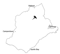 |
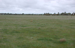
 Looking across the rises and plain towards Mount Mercer | 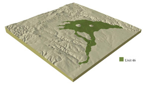 |
| 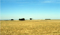 Grazing is the main land use of these volcanic plains |
Component | 1 | 2 | 3 | 4 |
Proportion of soil-landform unit | 15% | 55% | 28% | 2% |
| CLIMATE Rainfall (mm) | Annual: 690 | |||
| Temperature (oC) | Minimum 7, Maximum 18 | |||
| Precipitation less than potential evapotranspiration | October-March | |||
| GEOLOGY Age and lithology | Quaternary basalt, Ordovician marine sandstone and shale, Recent clay, sand and gravel | |||
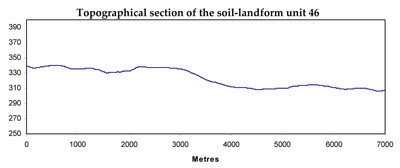
| Geomorphology | ||||
| LANDUSE | Uncleared areas: Nature conservation Cleared: Sheep and beef cattle grazing; cropping (cereal); softwood plantations | |||
| TOPOGRAPHY Landscape | Undulating low basalt hills | |||
| Elevation range (m) | 196-395 | |||
| Local relief (m) | 60 | |||
| Drainage pattern | Dendritic | |||
| Drainage density (km/km2) | 1.1 | |||
| Landform | Hillslopes | Flat | Drainage depressions | |
| Landform element | Broad crest and upper slopes | Mid and lower slopes | Plain | Drainage lines |
| Slope and range (%) | 3 (1-8) | 3 (2-6) | 1 (0-2) | 1 (0-4) |
| Slope shape | Convex | Linear/Concave | Straight | Concave |
| NATIVE VEGETATION Ecological Vegetation Class | Plains Grassland/Plains Grassy Woodland Mosaoic (0.7%), Valley Grassy Forest (0.2%), Heathy Dry Forest (0.1%) | |||
| SOIL Parent material | Basalt | Basalt and colluvium | Basalt and colluvium | Basalt, colluvium and alluvium |
| Description (Corangamite Soil Group) | Alkaline mottled black texture contrast soils (35) | Alkaline mottled black texture contrast soils (35) | Alkaline mottled black texture contrast soils (35) | |
| Soil type sites | ||||
| Surface texture | Loam | Clay loam | Clay loam | Clay loam |
| Permeability | Moderate | Low | Low | Very low |
| Depth (m) | <1.5 | <2 | <2 | <2 |
| LAND CHARACTERISTICS, POTENTIAL AND LIMITATIONS | Texture contrast and loam soils with moderate water holding capacity in variable depth surface and subsurface soils (gilgai), higher in deep expansive clay subsoil. High (loams to low permeability). Generally, strongly sodic subsoil. Some stone on broad crests/rises. Moderate site drainage. | Texture contrast soil with moderate water holding capacity and nutrient holding capacity in variable depth surface and subsurface soils (gilgai), higher in deep expansive clay subsoil. Low permeability. Generally, strongly sodic subsoil. Minor stone. Moderate site drainage. | Texture contrast soil with moderate water holding capacity and nutrient holding capacity in variable depth surface and subsurface soils (gilgai), higher in deep expansive clay subsoil. Low permeability. Generally, strongly sodic subsoil. Minor stone. Slow site drainage. | Texture contrst soil with moderate water holding capacity and nutrient holding capacity in variable depth surface and subsurface soils (gilgai), higher in deep expanisve clay subsoil. Low permeability. Generally, strongly sodic subsoil. Very slow site drainage. |
© State of Victoria (Agriculture Victoria) 1996 - .

This work, Victorian Resources Online, is licensed under a Creative Commons Attribution 4.0 licence. You are free to re-use the work under that licence, on the condition that you credit the State of Victoria (Agriculture Victoria) as author, indicate if changes were made and comply with the other licence terms.
The licence does not apply to ‘branding’ or some ‘images or photographs’ that may be owned by third parties. We ask you to seek prior approval to use images using the VRO feedback form. Access to higher quality images can also be provided on request.
This page was last updated on .