
Soil/Landform Unit 118
Landform Unit Description
Page top
 Stony rises and plains west of Mount Gellibrand |
3.27% of CMA region The stony rises between Rokewood and Armytage were among the first areas grazed in this part of Victoria. The two main occurrences include one extending from the Western Upland boundary south of Mount Mercer to Wingeel, and the other further south around Ombersely. The stony rises are both interconnected and solitary and they slope southwards towards the Barwon River. The area is found north of the Princes Highway, but occasional vents or old cones also occur within these rises. The nature of the native vegetation is difficult to determine. Many early reports describe the area as a treeless plain, but there are occasional specimens of Acacia melanoxylon, A. implexa and even Eucalyptus viminalis in roadside reserves. Thus, there may have originally been a low open woodland prior to settlement, which has disappeared following grazing and burning. Stony rise landscapes in other parts of Victoria possess woodland or low woodland communities. The soils are black self-mulching clays (Vertosols) and black gradational soils (Dermosols) on the rises, and (strongly sodic) mottled black texture contrast soils (Sodosols) and grey cracking clays (Vertosols) on the plains and depressions. Soil nutrient levels are high on these basalt outcrops, especially in the less weathered soils. The abundance of rock floaters and outcrops makes cultivation difficult even on infilled swamps between the rises. The plains and depressions may be susceptible to waterlogging, compaction and structure decline. Annual rainfall is greater in the southern occurrence of the unit with more intensive grazing, while sheep grazing and cropping occurs in the drier occurrence to the north. |  |
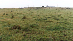
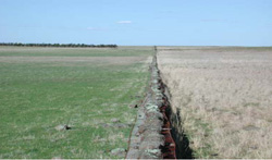
 Stony shelf overlooking lower plains towards The Sanctuary | 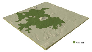 |
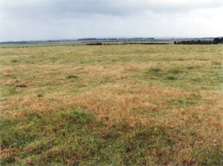
 |  Plain (possibly former swamp) with stony rises in the distance of this unit |
Component | 1 | 2 | 3 | 4 |
Proportion of soil-landform unit | 15% | 70% | 5% | 10% |
| CLIMATE Rainfall (mm) | Annual: 620 | |||
| Temperature (oC) | Minimum 8, Maximum 19 | |||
| Precipitation less than potential evapotranspiration | October-April | |||
| GEOLOGY Age and lithology | Quaternary basalt | |||
| Geomorphology | ||||
| LANDUSE | Uncleared areas: Water supply, nature conservation Cleared areas: Sheep and beef cattle grazing; cropping (cereal) | |||
| TOPOGRAPHY Landscape | Stony rise, undulating plain with occasional steep hills (volcanic cones) | |||
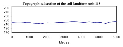
| Elevation range (m) | 70-301 | |||
| Local relief (m) | 3-8 | |||
| Drainage pattern | Centripetal | |||
| Drainage density (km/km2) | 0.8 | |||
| Landform | Rises | Plain and gentle slopes | Alluvial flat | |
| Landform element | Broad crest | Rise slopes | Plains | Depressions and drainage lines |
| Slope and range (%) | 6 (2-12) | 2 (0-6) | 1 (0-2) | 1 (0-3) |
| Slope shape | Convex | Convex, Straight | Straight | Concave |
| NATIVE VEGETATION Ecological Vegetation Class | Plains Grassland / Plains Grassy Woodland Mosaic (0.3%) | |||
| Dominant species | Acacia melanlxylon, A. implexa, Eucalyptus viminalis | |||
| SOIL Parent material | Basalt | Basalt | Basaltic colluvium | Basaltic colluvium and alluvium |
| Description (Corangamite Soil Group) | Grey cracking clays (39) | |||
| Soil type sites | CLRA49, CLRA51, CLRA52 | |||
| Surface texture | Light clay, clay loam | Clay loam | Clay loam | Light clay |
| Permeability | High | Moderate to high | Low | Very low |
| Depth (m) | <0.7 | <1.5 | <2, >2 | >2 |
| LAND CHARACTERISTICS, POTENTIAL AND LIMITATIONS | Expansive clays and uniform loams, moderate water holding capacity and nutrient holding capacity in varialbe depth soils. High permeability. Friable surfaces, including self-mulching. Common stone, minor low stone areas are cropped. Moderately rapid site drainage. Some sheet erosion. | Uniform loams and expansive clays, moderate to high water holding capacity and nutrient holding capacity in variable depth soils. High (loams) to low permeability. Friable surfaces including self-mulching. Common stone, low stone areas are cropped. Moderately rapid site drainage. Some sheet erosion. | Texture contrast soil with moderate water holding capacity and nutrient holding capacity in variable depth surface and subsurface soils (gilgai), higher in deep expansive clay subsoil. Low permeability. Generally, strongly sodic subsoil. Slow site drainage. | Texture contrast soil, moderate water holding capacity and nutrient holding capacity in variable depth surface and subsurface soils (gilgai), higher in deep expansive clay subsoil. Low permeability, sodic (often strongly) subsoil. Slow site drainage. |
© State of Victoria (Agriculture Victoria) 1996 - .

This work, Victorian Resources Online, is licensed under a Creative Commons Attribution 4.0 licence. You are free to re-use the work under that licence, on the condition that you credit the State of Victoria (Agriculture Victoria) as author, indicate if changes were made and comply with the other licence terms.
The licence does not apply to ‘branding’ or some ‘images or photographs’ that may be owned by third parties. We ask you to seek prior approval to use images using the VRO feedback form. Access to higher quality images can also be provided on request.
This page was last updated on .