
Soil/Landform Unit 42
Landform Unit Description
Page top
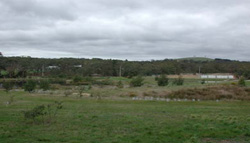
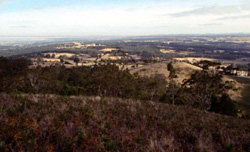 Looking north from Mount Buninyong over Green Hill towards Ballarat |
0.02% of CMA region The low cones of Green Hill form part of a sequence of volcanic landforms within the Midlands of the Western Uplands. These cones are characterised by cone crests and slopes, lower undulating slopes, stony rises and outcrops, depressions and alluvial terraces. The cones support the vegetation classes Heathy Dry Forest, Grassy Dry Forest, Grassy Woodland and Plains Grassy Woodland with the dominant species being manna gum (E. viminalis), narrow leaf peppermint (E. radiata), swamp gum (E. ovata) and messmate stringybark (E. obliqua). The slopes provide friable red gradational soils while the lower slopes host a mixture of sodic texture contrast soils. The depressions support black clays and the terraces have brown uniform soil. Shallow stony red gradational soils are found on stony crests and slopes. Agricultural land use is quite diverse and includes beef cattle and sheep grazing, hardwood forestry and water supply. Residential development and other forms of development (universities, technology parks, etc.) are likely to be the primary land use. Erosion hazards are minimal. Areas with shallow stony gradational soils are susceptible to leaching of nutrients, and compaction is a problem on the lower slopes and depressions. Minor gully erosion and waterlogging is associated with the lower slopes and the texture contrast soils. |  |
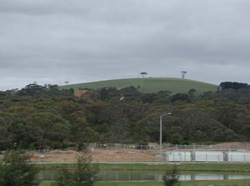 The crest of Green Hill rising above the remnant vegetation on the mid and lower slopes | 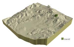 |
|  University of Ballarat occuping the mid to lower slopes of Green Hill |
Component | 1 | 2 | 3 | 4 | 5 |
Proportion of soil-landform unit | 30% | 50% | 5% | 5% | 10% |
| CLIMATE Rainfall (mm) | Annual: 880 | ||||
| Temperature (oC) | Minimum 6, Maximum 17 | ||||
| Precipitation less than potential evapotranspiration | November-March | ||||
| GEOLOGY Age and lithology | Pleistocene; basalt; scoria tuff | ||||
| Geomorphology | |||||
| LANDUSE | Uncleared: Nature conservation; passive and active recreation; water supply; hardwood forestry Cleared: Beef cattle and sheep grazing; cropping; residential development horticulture | ||||
| TOPOGRAPHY Landscape | Gently undulating low cones | ||||
| Elevation range (m) | 490-653 | ||||
| Local relief (m) | 80 | ||||
| Drainage pattern | Dendritic | ||||
| Drainage density (km/km2) | 0.3 | ||||
| Landform | Volcanic cone | Depression | Terrace | ||
| Landform element | Slopes and crest | Long gentle upper slopes | Depression | Stony rises | |
| Slope and range (%) | 25 (5-40) | 2 (1-3) | 1 (1-2) | 3 (2-5) | 1 (1-2) |
| Slope shape | Straight | Straight | Straight | Convex | Straight |
| NATIVE VEGETATION Ecological Vegetation Class | Heathy Dry Forest (4.9%), Grassy Dry Forest (3%), Grassy Woodland (2.6%), Plains Grassy Woodland (2%) | ||||
| Dominant species | E. viminalis, E. radiata | E. ovata, E. viminalis, E. rubida, E. obliqua | E. ovata, E. viminalis, E. rubida, E. obliqua | E. ovata, E. viminalis, E. rubida, E. obliqua | E. viminalis, E. radiata |
| SOIL Parent material | In situ weathered basalt and scoria | In situ weathered basalt and scoria | Alluvium | In situ weathered basalt | Unconsolidated gravel, sand, silt and clay |
| Description (Corangamite Soil Group) | Stony red gradational soil (40) | Black cracking clay soil, coarse structure (31) | Red shallow, stony gradational soil (40) | Dark brown soil (variable) (34) | |
| Soil type sites | |||||
| Surface texture | Clay loam | Clay loam | Clay | Clay loam | Fine sandy clay loam |
| Permeability | High | Moderate to low | Moderate | High | Moderate to low |
| Depth (m) | 1 | 1.5 | 1.5 | 0.5 | 2 |
| LAND CHARACTERISTICS, POTENTIAL AND LIMITATIONS | Steep slopes, overland flow, sheet erosion and nutrient decline are very minor. These soils have a high agricultural versatility. | Hardsetting surfaces and slowly permeable soils often result in overland flow and periodic waterlogging. Soil compaction and sheet erosion also occur. | Clay soils beside creeks are prone to waterlogging. Streambank and undercutting and streambank erosion occur where streambanks are exposed without adequate ground coverage. | Overland flow, sheet erosion and nutrient decline are very minor. These soils have a high agricultural versatility but are limited by surface stones. | Low-lying areas receiving drainage are prone to waterlogging and overland flow. Streambank erosion and gully erosion occur where soils are exposed without adequate ground coverage. |
© State of Victoria (Agriculture Victoria) 1996 - .

This work, Victorian Resources Online, is licensed under a Creative Commons Attribution 4.0 licence. You are free to re-use the work under that licence, on the condition that you credit the State of Victoria (Agriculture Victoria) as author, indicate if changes were made and comply with the other licence terms.
The licence does not apply to ‘branding’ or some ‘images or photographs’ that may be owned by third parties. We ask you to seek prior approval to use images using the VRO feedback form. Access to higher quality images can also be provided on request.
This page was last updated on .