
Soil/Landform Unit 21
Landform Unit Description
Page top
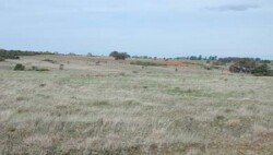
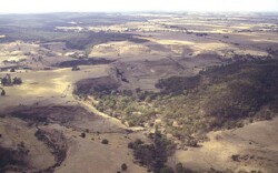 Plateaux of the dissected landscape near Happy Valley in the Western Uplands |
0.28% of CMA region This hills and plains unit is a member of the dissected Western Uplands. This unit of only two occurrences predominantly consists of a Neogene plain (plateau) which has been dissected and some moderately steep Palaeozoic low hills in the Pitfield, Cape Clear area. This unit is either close to or forms a boundary between the Western Uplands and the Western Plains. The soils are sodic often acidic, mottled brown texture contrast soils (Sodosols, Kurosols) on the plains, and shallow mottled red and yellow gradational soils (Dermosols) on the hills. The lighter surface soils are prone to nutrient decline and sheet and rill erosion. Sheet, rill, gully and minor mass movement are concerns on the steeper slopes. Nutrient levels are low in this unit and most of the soils are dispersible, the Neogene clays particularly so (due to sodicity). The predominant land use is grazing, with some mineral extraction on the plains and some hillslopes, while forestry, recreation and conservation are confined to the hills. |  |
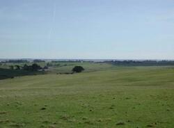 The main land use of these plains and slopes includes grazing and cropping (cereal) |  |
|  Gully and tunnel erosion is common on slopes and roadsides near Cape Clear |
Component | 1 | 2 | 3 | 4 | 5 | 6 |
Proportion of soil-landform unit | 1% | 12% | 1% | 11% | 74% | 1% |
| CLIMATE Rainfall (mm) | Annual: 660-720 | |||||
| Temperature (oC) | Minimum 8, Maximum 19 | |||||
| Precipitation less than potential evapotranspiration | October-March | |||||
| GEOLOGY Age and lithology | Neogene fluvio-marine sand, Orodivician marine sandstone and shale and minor Quaternary basalt | |||||
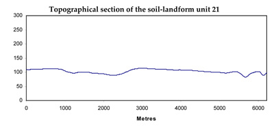
| Geomorphology | ||||||
| LANDUSE | Uncleared areas: Hardwood forestry; nature conservation Cleared: Sheep and beef cattle grazing; gravel extraction; mining | |||||
| TOPOGRAPHY Landscape | Moderate steep low hills and gently undulating plain | |||||
| Elevation range (m) | 185-324 | |||||
| Local relief (m) | 5-35 | |||||
| Drainage pattern | Dendritic | |||||
| Drainage density (km/km2) | 2.5 | |||||
| Landform | Low Hill | Plain | ||||
| Landform element | Southern slope | Northern slope | Drainage line | Creast | Non-sandy areas | Patches of deep sandy soil |
| Slope and range (%) | 15 (10-25) | 15 (10-25) | 4 (2-10) | 7 (0-15) | 1 (1-3) | 2 (1-3) |
| Slope shape | Straight | Straight | Concave | Convex | Convex | Convex |
| NATIVE VEGETATION Structure | Tall open forest | Open forest | Open forest | Open forest | Low open forest-woodland | Low open forest-woodland |
| Dominant species | E. obliqua, E. ovata, E. radiata, E. viminalis | E. dives, E. obliqua, E. viminalis, E. radiata | E. viminalis, E. radiata, E. obliqua | E. obliqua, E. dives, E. viminalis, E. radiata | E. viminalis, E. obliqua, E radiata, E. rubida, E. ovata, E. pauciflora | Pteridium esculentum, E. viminalis |
| SOIL Parent material | In situ weathered rock | In situ weathered rock | Unconsolidated sediments | In situ weathered rock | Unconsolidated gravel, sand and clay | Unconsolidated clay |
| Description (Corangamite Soil Group) | Mottled brown, grey or yellow gradational soils, fine structure (25) | Mottled brown, grey or yellow gradational soils, fine structure (25) | Black gradational soils (34) | Shallow stony red gradational soils (40) | Bronw, grey or yellow sand soils (8) | |
| Soil type sites | ||||||
| Surface texture | Fine sandy loam | Fine sandy loam | Clay loam | Gravelly loam | Sandy loam, sandy clay loam | Sand |
| Permeability | High | High | Moderate to low | High | Moderate | High |
| Depth (m) | 1 | 1 | 1.5 | 0.5 | 2 | 2 |
| LAND CHARACTERISTICS, POTENTIAL AND LIMITATIONS | Overland flow across the steeper slopes encourages sheet and rill erosion. Potential for minor mass movement. | Hardsetting surface soils on steep slopes can lead to compaction and are subject to overland flow and sheet and rill erosion. | Drainage lines are subject to seasonally high watertable and periodic waterlogging with some gully erosion. Hardsetting surface soils lead to surface compaction. | Hardsetting surface soils can lead to compaction and are subject to overland flow and sheet and rill erosion on moderate slopes. | Hardsetting surface soils lead to overland flow and sheet and rill erosion. Moderate permeable, leaching of salts and dispersive subsoils lead to gully erosion. | Hardsetting surface soils with low fertility lead to minor wind erosion. Highly permeable, leaching and dispersive subsoils with low fertility are common. |
© State of Victoria (Agriculture Victoria) 1996 - .

This work, Victorian Resources Online, is licensed under a Creative Commons Attribution 4.0 licence. You are free to re-use the work under that licence, on the condition that you credit the State of Victoria (Agriculture Victoria) as author, indicate if changes were made and comply with the other licence terms.
The licence does not apply to ‘branding’ or some ‘images or photographs’ that may be owned by third parties. We ask you to seek prior approval to use images using the VRO feedback form. Access to higher quality images can also be provided on request.
This page was last updated on .