
Soil/Landform Unit 175
Landform Unit Description
Page top
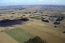 Gently undulating plains near Irrewillipe |
0.6 % of CMA region This unit forms an apron of sediments (mainly Neogene) from Colac west to Pirron Yallock, with components of broad low crests, slopes and plains. As a member of the sedimentary Western Plains, the unit is bound by stony rises (Units 113, 114) and alluvium to the north, and alluvial flats (Unit 191) and undulating sedimentary rises (Unit 170) to the south. Native vegetation classes of the unit include Grassy Woodland and Plains Grassy Woodland. The soils are sodic, mottled black texture contrast soils (Sodosols) that are susceptible to waterlogging on the plains and drainage lines. Rainfall is sufficient to sustain intensive grazing (dairying) and other uses such as plantations or woodlots. Excavation of peats is also undertaken on these gently undulating plains. Susceptibility to nutrient decline and minor sheet erosion particularly applies to the slopes. Increasing sodicity may be a problem in the lower landscape positions. |  |
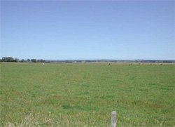 The level plains near Bungador are especially prone to seasonal waterlogging | 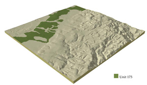 |
 | 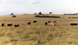 The level plains near Warncoort are mainly used for grazing and cropping |
Component | 1 | 2 | 3 | 4 | 5 |
Proportion of soil-landform unit | 7% | 20% | 30% | 40% | 3% |
| CLIMATE Rainfall (mm) | Annual: 810 | ||||
| Temperature (oC) | Minimum 8, Maximum 19 | ||||
| Precipitation less than potential evapotranspiration | November–March | ||||
| GEOLOGY Age and lithology | Neogene fluvial and marine sediments, Recent clay, sand and gravel and minor basalt | ||||
| Geomorphology | |||||
| LANDUSE | Uncleared: Nature conservation; water supply Cleared: Dairy farming; beef cattle and sheep grazing; cropping (wide range of cereals); horticulture | ||||
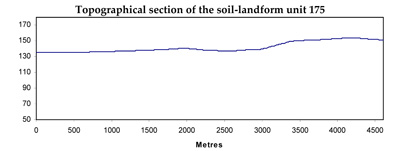
| TOPOGRAPHY Landscape | Gently undulating plains | ||||
| Elevation range (m) | 114–168 | ||||
| Local relief (m) | 20 | ||||
| Drainage pattern | Centripetal–parallel | ||||
| Drainage density (km/km2) | 0.6 | ||||
| Landform | Gentle slopes | Plains | Drainage lines | ||
| Landform element | Broad low crests | Mid and upper slopes | Lower slopes | Plain | Drainage depressions |
| Slope and range (%) | 4 (1–7) | 5 (3–12) | 3 (2–5) | 1 (0–3) | 2 (1–3) |
| Slope shape | Convex | Convex | Convex | Straight | Concave |
| NATIVE VEGETATION Ecological Vegetation Class | Grassy Woodland (0.4%), Plains Grassy Woodland (0.3%) | ||||
| SOIL Parent material | Sand, silt and clay | Sand, silt and clay | Sand, silt and clay | Sand, silt and clay | Alluvial sand, silt and clay |
| Description (Corangamite Soil Group) | Neutral mottled black texture contrast soils (14) | Acidic and neutral mottled black texture contrast soils (14) | |||
| Soil type sites | |||||
| Surface texture | Loam, fine sandy | Loam, fine sandy | Loam, fine sandy | Loam, fine sandy | Light clay; loam, fine sandy |
| Permeability | Moderate | Low to moderate | Low | Low | Very low |
| Depth (m) | <2 | <2 | <2 | >2 | >2 |
| LAND CHARACTERISTICS, POTENTIAL AND LIMITATIONS | Texture contrast, low to moderate water holding capacity and nutrient holding capacity depending on depth and stoniness in upper soil, high in subsoil. Non-sodic (moderate structure) and sodic (coarse structure) subsoils. Moderate site drainage. Some susceptibility to nutrient decline and sheet and rill erosion. | Texture contrast, low to moderate water holding capacity and nutrient holding capacity depending on depth and stoniness in upper soil, high in subsoil. Non-sodic (moderate structure) and sodic (coarse structure) subsoils. Moderate site drainage. Some susceptibility to nutrient decline and sheet and rill erosion. | Texture contrast, low to moderate water holding capacity and nutrient holding capacity depending on depth and stoniness in upper soil, high in subsoil. Non-sodic (moderate structure) and sodic (coarse structure) subsoils. Moderate to slow site drainage. Some susceptibility to nutrient decline, sheet and rill erosion. | Texture contrast, low to moderate water holding capacity and nutrient holding capacity depending on depth and stoniness in upper soil, high in subsoil. Non-sodic (moderate structure) and sodic (coarse structure) subsoils. Slow site drainage. Some susceptibility to nutrient decline and sheet and rill erosion. | Texture contrast and expansive clays, low to high water holding capacity and nutrient holding capacity depending on depth in upper soil, high in subsoil. Non-sodic (moderate structure) and sodic (coarse structure) subsoils. Very slow site drainage. Some susceptibility to waterlogging and nutrient decline. |
© State of Victoria (Agriculture Victoria) 1996 - .

This work, Victorian Resources Online, is licensed under a Creative Commons Attribution 4.0 licence. You are free to re-use the work under that licence, on the condition that you credit the State of Victoria (Agriculture Victoria) as author, indicate if changes were made and comply with the other licence terms.
The licence does not apply to ‘branding’ or some ‘images or photographs’ that may be owned by third parties. We ask you to seek prior approval to use images using the VRO feedback form. Access to higher quality images can also be provided on request.
This page was last updated on .