
Soil/Landform Unit 113
Landform Unit Description
Page top
 The stony rises of Pombornbeit are a topographically significant landform of the plains that offer little land use potential but high environmental (biodiversity) value |
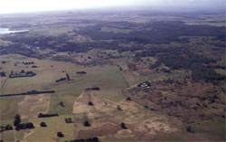
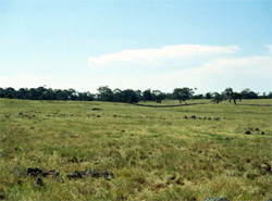
1.28% of CMA region This unit consists of gently undulating rises (hummocky stony rises) and associated drainage depressions and flats. This unit occurs within the volcanic Western Plains. Relief is quite subdued on these stony rises, however, relief has a large influence on component performance. This unit has a number of components, some (such as the low rises and undulating plain) are erosional, while others (such as the depressions and flats) are depositional. This relatively young terrain unit in the Pomborneit area is adjacent to basaltic undulating plains near Lake Corangamite in the east, and swamps and sedimentary terrain to the south-west. Native vegetation is scarse with Stony Rises Herb-rich Woodland, Plains Sedgy Wetland and Swamp Scrub the major classes. Within this unit there is an excellent example of remnant vegetation located on the stony rises. The soils are shallow black and red friable gradational soils with black cracking self-mulching soils on the depressions and flats. Agricultural land use is generally grazing, with the capability of the unit varying with component composition. The undulating plains between the rises are probably the most sought after, agriculturally. Waterlogging and stony soils provide the greatest limitations to cropping. | 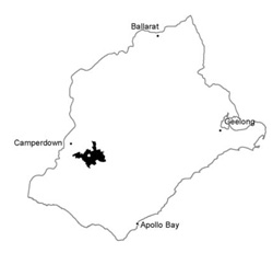 |
 Stony rise flow of Mount Pomborneit | 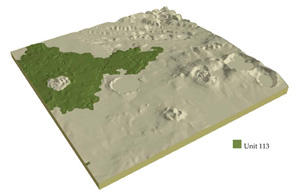 |
 | 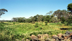 Remnant vegetation of the stony rises |
Component | 1 | 2 | 3 | 4 |
Proportion of soil-landform unit | 55% | 30% | 13% | 2% |
| CLIMATE Rainfall (mm) | Annual: 790 | |||
| Temperature (oC) | Minimum 8, Maximum 19 | |||
| Precipitation less than potential evapotranspiration | November-March | |||
| GEOLOGY Age and lithology | Quaternary basalt and minor scoria, Recent clay, sand and gravel | |||
| Geomorphology | ||||
| LANDUSE | Uncleared: Nature conservation; water supply Cleared: Beef cattle and sheep grazing; minor cropping | |||
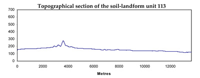
| TOPOGRAPHY Landscape | Undulating stony rises | |||
| Elevation range (m) | 107-196 | |||
| Local relief (m) | 5 | |||
| Drainage pattern | Centripetal-deranged | |||
| Drainage density (km/km2) | 0.5 | |||
| Landform | Stony rises | Drainage depressions | ||
| Landform element | Stony hummocks and ridges | Undulating plains | Depressions | Drainage lines |
| Slope and range (%) | 4 (1-7) | 2 (0-5) | 1 (0-2) | 1 (0-3) |
| Slope shape | Convex | Straight | Concave | Concave |
| NATIVE VEGETATION Ecological Vegetation Class | Stony Rises Herb-rich Woodland (2.2%), Plains Sedgy Wetland (0.6%), Swamp Scrub (0.5%) | |||
| SOIL Parent material | In situ basalt | In situ basalt and colluvium | Baslatic alluvium; clay silt and sand | Basaltic alluvium; clay silt and sand |
| Description (Corangamite Soil Group) | Shallow, red or black loams (40) | Black cracking clays (31) | Black cracking clays (31) | |
| Soil type sites | ||||
| Surface texture | Clay loam or loam | Clay loam, light medium clay | Medium clay | Light medium clay |
| Permeability | High | Moderate to high | Very low | Low |
| Depth (m) | <0.7 | <1.5 | >2 | >2 |
| LAND CHARACTERISTICS, POTENTIAL AND LIMITATIONS | Shallow, stony soils. Friable. Stongly structured. Moderate to high nutrient holding capacity. Well drained but low water holding capacity. | Shallow, stony soils and deeper clay soils. Friable. Strongly structured. Moderate to high nutrient holding capacity. Well drained but low water holding capacity where shallow. | High seasonal watertable leads to soil compaction. High organic matter content, high clay content and expansive clays. May be better drained where lighter soil occurs. | High seasonal watertable leads to soil compaction. High organic matter content, high clay content and expansive clays. May be better drained where lighter soil occurs. |
© State of Victoria (Agriculture Victoria) 1996 - .

This work, Victorian Resources Online, is licensed under a Creative Commons Attribution 4.0 licence. You are free to re-use the work under that licence, on the condition that you credit the State of Victoria (Agriculture Victoria) as author, indicate if changes were made and comply with the other licence terms.
The licence does not apply to ‘branding’ or some ‘images or photographs’ that may be owned by third parties. We ask you to seek prior approval to use images using the VRO feedback form. Access to higher quality images can also be provided on request.
This page was last updated on .