
Soil/Landform Unit 170
Landform Unit Description
Page top
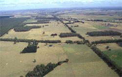 Looking west towards the Heytesbury. The undulating rises of this unit occur at the footslopes of the Otway Ranges. |
0.41% of CMA region Sedimentary undulating rises near Larpent (south-west of Colac), are characterised by crests, slopes and drained plains that adjoin the steeply dissected areas of the Heytesbury region. This single southern unit located within the Western Plains has formed on Neogene sandy sediments and is bound by rolling hills (Unit 92) to the south and alluvial flats (Unit 191) to the north. This unit is part of a foothill complex to the Southern Uplands. The soils are brown mottled texture contrast soils (Chromosols) with minor mottled black texture contrast soils (Chromosols); and the remnant vegetation class is Lowland Forest. Rainfall increases to the south and supports grazing as well as some softwood and hardwood timber plantations. The light topsoils are susceptible to nutrient decline, and steeper slopes are susceptible to sheet and rill erosion. | 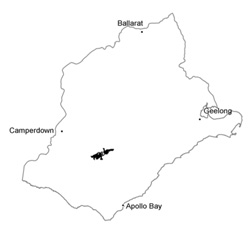 |
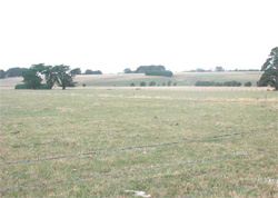 Cleared undulating rises near Irrewillipe are mainly used for dairy farming | 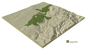 |
 | 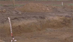 Sandy brown mottled texture contrast soils are indicative of soils across these plains |
Component | 1 | 2 | 3 |
Proportion of soil-landform unit | 20% | 60% | 20% |
| CLIMATE Rainfall (mm) | Annual: 900 | ||
| Temperature (oC) | Minimum 8, Maximum 18 | ||
| Precipitation less than potential evapotranspiration | November - March | ||
| GEOLOGY Age and lithology | Paleogene marine carbonaceous clay, silt and sand and Neogene fluvial-marine clay sand and gravel | ||
| Geomorphology | |||
| LANDUSE | Uncleared areas: Nature conservation; water supply Cleared areas: Dairy farming; beef cattle and sheep grazing; softwood plantations | ||
| TOPOGRAPHY Landscape | Undulating rises | ||
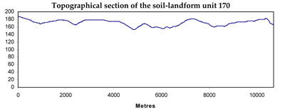
| Elevation range (m) | 134-209 | ||
| Local relief (m) | 25 | ||
| Drainage pattern | Centripetal-parallel | ||
| Drainage density (km/km2) | 0.7 | ||
| Landform | Rises | Plains | |
| Landform element | Crests and upper slopes | Mid and lower slopes | Plains and drainage lines |
| Slope and range (%) | 5 (1-10) | 6 (3-10) | 1 (0-2) |
| Slope shape | Convex | Convex | Straight |
| NATIVE VEGETATION Ecological Vegetation Class | Lowland Forest (2.4%) | ||
| SOIL Parent material | Clay, sand and gravel and carbonaceous clay, silt and sand | Clay, sand and gravel and carbonaceous clay, silt and sand | Clay, sand and gravel and carbonaceous clay, silt and sand |
| Description (Corangamite Soil Group) | Neutral and acidic brown mottled texture contrast soils (13) | Neutral and acidic brown mottled texture contrast soils (13) | |
| Soil type sites | SW66, SW68, SW67 | ||
| Surface texture | Fine sandy loam | Fine sandy loam, light fine sandy clay loam | Fine sandy loam |
| Permeability | Moderate | Moderate to low | Very low |
| Depth (m) | <2 | <2 | >2 |
| LAND CHARACTERISTICS, POTENTIAL AND LIMITATIONS | Strong texture contrast, low water holding capacity and nutrient holding capacity in surface soils, higher in subsoil. Low to moderate permeability in subsoil. Leaching more likely in subsurface and surface soil. Moderate rapid site drainage. | Strong texture contrast, low water holding capacity and nutrient holding capacity in surface soils, higher in subsoil. Low permeability in subsoil. Leaching more likely in subsurface and surface soil. Moderately rapid to slow site drainage. | Strong texture contrast, low water holding capacity and nutrient holding capacity in surface soils, higher in subsoil. Low permeability in subsoil. Leaching more likely in subsurface and surface soil. Slow site drainage. |
© State of Victoria (Agriculture Victoria) 1996 - .

This work, Victorian Resources Online, is licensed under a Creative Commons Attribution 4.0 licence. You are free to re-use the work under that licence, on the condition that you credit the State of Victoria (Agriculture Victoria) as author, indicate if changes were made and comply with the other licence terms.
The licence does not apply to ‘branding’ or some ‘images or photographs’ that may be owned by third parties. We ask you to seek prior approval to use images using the VRO feedback form. Access to higher quality images can also be provided on request.
This page was last updated on .