
Soil/Landform Unit 114
Landform Unit Description
Page top
 Stony rises surround the volcanic scoria cones of red rock and surrounding hills |
1.58% of CMA region The undulating basalt plains in the Warrion-Dreeite area are dominated by stony rises that surround the scoria, basalt and ash derived low hills and undulating plains of the Alvie area. These undulating basalt plains form a part of the volcanic landforms of the Western Plains. The plains are characterised by relatively stone-free flats that occur between prominent stony rises. The stony rises and flats support little remnant vegetation including the vegetation classes Stony Rises Herb-rich Woodland and Plains Grassy Woodland. The relatively young landscape has developed shallow friable loams on the stony rises, and neutral black and red gradational soils on the undulating plains. The flats and depressions have grey and black cracking clays that remain waterlogged in wet seasons. The soils are friable and productive but generally shallow and stony. Rainfall decreases from south to north, influencing grazing intensity (for dairying or beef/sheep production). Cropping is limited to areas that are relatively stone-free. | 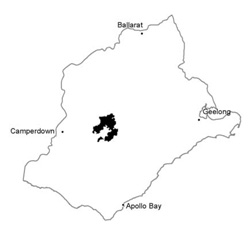 |
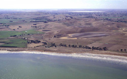
 View across stony rises towards Warrion Hill | 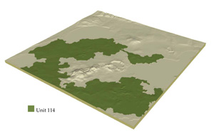 |
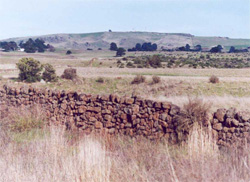
 | 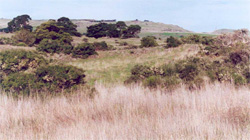 Stony rises with remnant vegetation |
Component | 1 | 2 | 3 | 4 |
Proportion of soil-landform unit | 25% | 60% | 5% | 10% |
| CLIMATE Rainfall (mm) | Annual: 630 | |||
| Temperature (oC) | Minimum 8, Maximum 19 | |||
| Precipitation less than potential evapotranspiration | November-March | |||
| GEOLOGY Age and lithology | Quaternary basalt and minor scoria, Recent clay, sand and gravel | |||
| Geomorphology | ||||
| LANDUSE | Uncleared: Nature conservation; water supply Cleared: Beef cattle and sheep grazing; minor cropping | |||
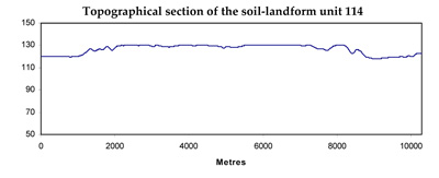
| TOPOGRAPHY Landscape | Undulating basalt plains | |||
| Elevation range (m) | 113-165 | |||
| Local relief (m) | 10 | |||
| Drainage pattern | Centripetal-deranged | |||
| Drainage density (km/km2) | 0.9 | |||
| Landform | Stony rises | Swamps and water bodies | ||
| Landform element | Undulating stony rises | Gently undulating plains | Drainage depressions | Swamps |
| Slope and range (%) | 2 (1-4) | 1 (0-3) | 2 (1-5) | 1 (0-1) |
| Slope shape | Convex | Straight | Concave | Concave |
| NATIVE VEGETATION Ecological Vegetation Class | Stony Rises Herb-rich Woodland (1.6%), Plains Grassy Woodland (0.4%) | |||
| SOIL Parent material | In situ basalt and ash | In situ basalt, ash and colluvial material | Basaltic colluvium and alluvium | Basaltic alluvium; clay and silt |
| Description (Corangamite Soil Group) | Alkaline grey cracking clays and some black cracking clays (39) | Alkaline grey cracking clays and some black cracking clays (31) | ||
| Soil type sites | ||||
| Surface texture | Clay loam to loam | Clay loam | Light medium clay | Medium clay |
| Permeability | High | High | Very low | Very low |
| Depth (m) | <0.7 | <1.5 | >1 | >2 |
| LAND CHARACTERISTICS, POTENTIAL AND LIMITATIONS | Friable, stongly structured soil. Shallow soil with low water holding capacity. Well drained. Moderate to high nutrient holding capacity. | Friable, strongly structured soil. Shallow soil with low water holding capacity. Well drained. Moderate to high nutrient holding capacity. | Friable, strongly structured soil. Deep heavy clay soil but with high expansive characteristics. High nutrient holding capacity, often calcareous and sodic. Poor drainage. | Firable, strongly structured soil. Deep heavy clay soil but with high expansive characteristics. High nutrient holding capacity, often calcareous and sodic. Very poor to poor drainage and susceptible to waterlogging and associated compaction. |
© State of Victoria (Agriculture Victoria) 1996 - .

This work, Victorian Resources Online, is licensed under a Creative Commons Attribution 4.0 licence. You are free to re-use the work under that licence, on the condition that you credit the State of Victoria (Agriculture Victoria) as author, indicate if changes were made and comply with the other licence terms.
The licence does not apply to ‘branding’ or some ‘images or photographs’ that may be owned by third parties. We ask you to seek prior approval to use images using the VRO feedback form. Access to higher quality images can also be provided on request.
This page was last updated on .